US9754226B2 - Urban computing of route-oriented vehicles - Google Patents
Urban computing of route-oriented vehicles Download PDFInfo
- Publication number
- US9754226B2 US9754226B2 US13/324,758 US201113324758A US9754226B2 US 9754226 B2 US9754226 B2 US 9754226B2 US 201113324758 A US201113324758 A US 201113324758A US 9754226 B2 US9754226 B2 US 9754226B2
- Authority
- US
- United States
- Prior art keywords
- regions
- route
- transitions
- pair
- gps points
- Prior art date
- Legal status (The legal status is an assumption and is not a legal conclusion. Google has not performed a legal analysis and makes no representation as to the accuracy of the status listed.)
- Active
Links
Images


Classifications
-
- G—PHYSICS
- G06—COMPUTING; CALCULATING OR COUNTING
- G06Q—INFORMATION AND COMMUNICATION TECHNOLOGY [ICT] SPECIALLY ADAPTED FOR ADMINISTRATIVE, COMMERCIAL, FINANCIAL, MANAGERIAL OR SUPERVISORY PURPOSES; SYSTEMS OR METHODS SPECIALLY ADAPTED FOR ADMINISTRATIVE, COMMERCIAL, FINANCIAL, MANAGERIAL OR SUPERVISORY PURPOSES, NOT OTHERWISE PROVIDED FOR
- G06Q10/00—Administration; Management
- G06Q10/06—Resources, workflows, human or project management; Enterprise or organisation planning; Enterprise or organisation modelling
-
- G—PHYSICS
- G08—SIGNALLING
- G08G—TRAFFIC CONTROL SYSTEMS
- G08G1/00—Traffic control systems for road vehicles
- G08G1/01—Detecting movement of traffic to be counted or controlled
- G08G1/0104—Measuring and analyzing of parameters relative to traffic conditions
- G08G1/0108—Measuring and analyzing of parameters relative to traffic conditions based on the source of data
- G08G1/0112—Measuring and analyzing of parameters relative to traffic conditions based on the source of data from the vehicle, e.g. floating car data [FCD]
-
- G—PHYSICS
- G08—SIGNALLING
- G08G—TRAFFIC CONTROL SYSTEMS
- G08G1/00—Traffic control systems for road vehicles
- G08G1/01—Detecting movement of traffic to be counted or controlled
- G08G1/0104—Measuring and analyzing of parameters relative to traffic conditions
- G08G1/0125—Traffic data processing
- G08G1/0129—Traffic data processing for creating historical data or processing based on historical data
Definitions
- Ubiquitous computing is a model of human-computer interaction to integrate information processing into daily activities. For instance, ubiquitous computing includes multiple computational devices and systems operating simultaneously. Recently, ubiquitous computing is applied to urban areas, which includes physical movements and interpretations of social context. As a result, urban computing is emerging as a concept where every sensor, person, vehicle, building, and street in the urban areas may be used as a computing component for serving people and their towns or their cities.
- Urban computing may be used for urban planning that integrates land-use planning and transportation planning to improve built, economic, and social environments of communities.
- Urbanization is increasing at a fast pace in developing countries. Meanwhile, urban reconstruction, renewal, and suburbanization are occurring in countries that have already been developed.
- opportunities for innovative technologies may automatically and inconspicuously sense urban dynamics and provide crucial information to urban planners.
- a large number of taxicabs transport passengers in urban areas.
- Some taxicabs may be equipped with sensors to record their location data to a centralized server at regular intervals.
- the taxicabs may be considered to be ubiquitous mobile sensors constantly probing the urban areas' traffic patterns.
- a process collects sequences of global positioning system (GPS) points in the logs and identifies geographical locations to represent the urban area where the route-oriented vehicles traveled based on the logs.
- GPS global positioning system
- the process models traffic patterns in the urban area by: partitioning the urban area into regions based at least in part on major roads, segmenting the GPS points from the logs into time slots, and identifying the GPS points associated with transporting a passenger in the route-oriented vehicles.
- the process further models traffic patterns by projecting the identified GPS points onto the regions to construct transitions of the identified GPS points travelling between the regions. Then the process builds a matrix of the regions for each time slot in each day based on a number of the transitions. Each item in the matrix represents an effectiveness of connectivity between the regions.
- an interface receives user input for an urban area to be evaluated for an efficiency of the planning of the urban area.
- An area computing application receives sequences of global positioning system (GPS) points from logs of route-oriented vehicles and creates a model of the traffic patterns in the urban area being selected based on the GPS points.
- the model identifies pairs of regions in the urban area having a set of transitions between them when travelling in the regions.
- the area computing application aggregates the transitions to associate each pair of regions with a volume of traffic between the pair of regions, expected travel speeds of the transitions, and a ratio between an actual travel distance and an Euclidan distance between centroids of each of the pair of regions.
- An identified pair of regions may require the route-oriented vehicles to take detours based on congested traffic when travelling between the identified pair of regions. Based on this evaluation, recommendations may be provided for converting streets to one way streets, adding more lanes to the streets, adding more roads, adding another subway line, adding a bus stop, adding a train stop, building a shopping area, and the like.
- FIG. 1 illustrates an architecture to support an example environment to evaluate an effectiveness of planning of an urban area.
- FIG. 2 is a flowchart showing example phases to: collect GPS points, model traffic patterns between the regions, identify a set of skylines from a model, and evaluate effectiveness of the planning of the urban area to be used in the architecture of FIG. 1 .
- FIG. 3 is a flowchart showing an example process of collecting the GPS points from the logs of the route-oriented vehicles.
- FIG. 4 is a flowchart showing an example process of modeling traffic patterns and connectivity between the regions in the urban area based on the GPS points.
- FIG. 5 illustrates an example map of partitioning the urban area into regions based at least on using major roads.
- FIGS. 6A and 6B illustrate example charts of segmenting the GPS points into time slots for weekdays and weekends/holidays, respectively with their speeds.
- FIG. 7 illustrates an example process of projecting the GPS points onto the regions and constructing transitions between the regions.
- FIG. 8 illustrates an example graph of pairs of regions having a set of transitions between them.
- FIG. 9 illustrates an example graph of a set of skylines from the model to represent a portion of the urban area.
- FIG. 10 illustrates example kinds of pairs of regions in the set of skylines.
- FIG. 11 illustrates an example process of formulating skyline graphs based on the pairs of regions connected from consecutive time slots.
- FIG. 12 illustrates examples of mined frequent skyline patterns.
- FIG. 13 illustrates an example heat map of the urban area using shapes to represent a number of passengers reaching the regions.
- FIG. 14 is a block diagram showing an example server usable with the environment of FIG. 1 .
- This disclosure describes evaluating effectiveness of an urban area based on information collected from the logs of the route-oriented vehicles.
- the route-oriented vehicles travel frequently in the urban area to pick up passengers and to drop the passengers off in their desired destinations.
- a majority of the route-oriented vehicles tend to be equipped with sensors, such as global positioning system (GPS) sensors, which enable the route-oriented vehicles to report their locations to a centralized server at regular intervals.
- GPS global positioning system
- the sensors may collect the GPS points at regular intervals, such as every one to two minutes, every two to five minutes, or may be set at shorter or longer intervals.
- the route-oriented vehicles equipped with the sensors are constantly probing the urban areas' traffic patterns, such as traffic flow on the roads and city-wide travel patterns of people in the route-oriented vehicles.
- a large city may have approximately 67,000 route-oriented vehicles generating an average of 1.2 million trips per day with passengers in the route-oriented vehicles.
- the 1.2 million trips per day generated by the route-oriented vehicles tend to have an average of 1.2 passengers per trip.
- This number represents about 5% of total personal trips created by various transportation systems including buses, subways, private vehicles, and the route-oriented vehicles.
- the route-oriented vehicles represent actual traffic patterns on the roads in the urban area.
- a process may create a model to model traffic patterns and to connect the traffic flows between the regions in the urban area.
- Traffic data is collected via the GPS sensors in logs of the route-oriented vehicles.
- a process extracts trajectories, which are sequences of GPS points from the logs.
- the trajectories represent trips for the route-oriented vehicles and imply human knowledge from drivers of the route-oriented vehicles.
- human knowledge may include driving conditions during rush hour, road constructions, direction turns, and the like.
- FIG. 1 illustrates an example architectural environment 100 , in which an evaluation of an effectiveness of planning of an urban area may be determined on a computing device.
- the environment 100 includes an example computing device 102 , which is illustrated as a mobile device.
- the computing device 102 is configured to connect via one or more network(s) 104 to access a planning service 106 for a user 108 .
- the computing device 102 may take a variety of forms, including, but not limited to, a portable handheld computing device (e.g., a personal digital assistant, a smart phone, a cellular phone), a personal navigation device, a laptop computer, a desktop computer, a portable media player, or any other device capable of connecting to one or more network(s) 104 to access the planning service 106 for the user 108 .
- a portable handheld computing device e.g., a personal digital assistant, a smart phone, a cellular phone
- a personal navigation device e.g., a personal navigation device, a laptop computer, a desktop computer, a portable media player, or any other device capable of connecting to one or more network(s) 104 to access the planning service 106 for the user 108 .
- the network(s) 104 represents any type of communications network(s), including wire-based networks (e.g., cable), wireless networks (e.g., cellular, satellite), cellular telecommunications network(s), WiFi networks, and IP-based telecommunications network(s).
- the planning service 106 represents an urban planning service that may be operated as part of any number of online service providers, such as a search engine. In another implementation, the planning service 106 may be a map-based application stored in memory of the computing device 102 . Updates with GPS logs and trajectories may be sent for an area computing application that is stored on a mobile device.
- the computing device 102 may include a user interface (UI) 110 that is presented on a display of the computing device 102 .
- the user interface 110 facilitates access to the planning service 106 that provides the evaluation of the planning of urban area(s).
- the user 108 also employs the UI 110 to submit a request for an urban area from the planning service 106 .
- the UI 110 is a browser-based UI that presents a page received from the trajectory datasets of the route-oriented vehicles.
- the UI 110 shows trajectory datasets for “Year X” and “Year Y.”
- the UI 110 illustrates the datasets are collected from about 29,800 route-oriented vehicles in Year X and from about 32,400 route-oriented vehicles in Year Y.
- the UI 100 also illustrates the number of GPS points is approximately 978 million in Year X and approximately 1730 million in Year Y.
- the planning service 106 is hosted on one or more area computing servers, such as area computing server(s) 112 ( 1 ), 112 ( 2 ), . . . , 112 (S), accessible via the network(s) 104 .
- the area computing servers 112 ( 1 )-(S) may be configured as plural independent servers, or as a collection of servers that are configured to perform larger scale functions accessible by the network(s) 104 .
- the area computing server(s) 112 may be administered or hosted by a network service provider that provides the planning service 106 to and from the computing device 102 .
- the planning service 106 further includes an area computing application 114 that executes on one or more of the area computing servers 112 ( 1 )-(S).
- the area computing application 114 provides the evaluation of the effectiveness of the urban area, which first includes collecting logs from the route-oriented vehicles. Data from the route-oriented vehicles are used as drivers are very familiar with urban roads and time-variant traffic flows on the urban roads. The drivers know the fastest routes, which are short and quick, but not necessarily the shortest in distance. Thus, the data of the route-oriented vehicles enhances the area computing application 114 by mining human knowledge, such as learning smart driving directions.
- the area computing application 114 processes the global positioning system (GPS) logs from various types of route-oriented vehicles. Based on the logs collected, the area computing application 114 identifies geographical locations where the route-oriented vehicles have traveled to generate a map of the urban area. To better identify effective driving directions in the geographical locations, the area computing application 114 parses trajectories from the logs.
- the urban area may be further partitioned into multiple regions based at least on the major roads.
- the trajectory datasets may be stored in a database 116 , which is then used to construct a model based at least in part on the traffic patterns of the route-oriented vehicles.
- the model involves associating each route-oriented vehicle trajectory to a corresponding region in the urban area. Details of constructing the model are described with reference to FIGS. 4-8 .
- the environment 100 may include the database 116 , which may be a separate server or may be a representative set of server 112 that is accessible via the network(s) 104 .
- the database 116 may store information, such as logs for one or more route-oriented vehicle(s) 118 , a sequence of global positioning system (GPS) points, trajectories archive, graphs, a matrix, models, other data, and the like.
- GPS global positioning system
- the environment 100 shows a representation of the urban area 120 computed as a result of the GPS logs from the route-oriented vehicles 118 .
- the representation of the urban area 120 illustrates evaluations and recommendations performed by the area computing application 114 to the user 108 .
- at 122 is a recommendation for a subway line to decrease the traffic.
- FIG. 2 is a flowchart of an example process 200 showing high-level functions performed by the area computing application 114 .
- These processes are illustrated as logical flow graphs, each operation of which represents a sequence of operations that can be implemented in hardware, software, or a combination thereof.
- the operations represent computer-executable instructions stored on one or more computer-readable storage media that, when executed by one or more processors, perform the recited operations.
- computer-executable instructions include routines, programs, objects, components, data structures, and the like that perform particular functions or implement particular abstract data types.
- the processes are described with reference to the computing environment 100 shown in FIG. 1 . However, the processes may be performed using different environments and devices. Moreover, the environments and devices described herein may be used to perform different processes.
- the area computing application 114 provides the evaluation of the urban area based on the log information collected from the route-oriented vehicles 118 .
- the process 200 may be divided into four phases, an initial phase to collect GPS points from logs of route-oriented vehicles 202 , a second phase to model traffic patterns and connectivity between the regions in the urban area based on the GPS points 204 , a third phase to identify a set of skylines from the model to represent a portion of the urban area 206 , and a fourth phase to evaluate the effectiveness of planning of the urban area 208 . All of the phases may be used in the environment of FIG. 1 , may be performed separately or in combination, and without any particular order.
- the first phase is to collect the GPS points from the logs of the route-oriented vehicles 202 .
- the area computing application 114 collects the logs from various types of route-oriented vehicles 118 that transport passengers, including but not limited to taxicabs, limousines, and shuttles. These types of route-oriented vehicles 118 tend to focus on picking up and dropping off passengers in the urban area.
- the logs may be obtained from GPS sensors located on each of the route-oriented vehicles 118 .
- the logs are generally a collection of GPS points, which includes a date, a time, a longitude coordinate, and a latitude coordinate.
- the route-oriented vehicles 118 may include a weight sensor for each of the route-oriented vehicles 118 to detect passengers other than the driver, a weight sensor to determine an occupancy status in a passenger seat of the route-oriented vehicle 118 , an identifier for the driver to specify a passenger is present in the route-oriented vehicle 118 , and the like. From the logs, the geographical locations are identified in the urban area.
- the second phase is to model traffic patterns and connectivity between the regions in the urban area based on the GPS points 204 .
- the area computing application 114 models the traffic patterns by: partitioning the urban area into regions based at least in part on major roads, segmenting the GPS points from the logs into time slots, and identifying the GPS points associated with transporting a passenger in the route-oriented vehicles 118 .
- the area computing application 114 projects the GPS points onto the regions to identify pairs of regions having a set of transitions between them when travelling in the regions and builds a matrix for the regions.
- the third phase is to identify a set of skylines from the model to represent a portion of the urban area 206 .
- the term skyline describes a graphical representation of the data.
- the set of skylines represents the GPS points with travel speeds and ratios of actual travel distance and an Euclidan distance between centroids of each of the pair of regions, which are less efficient than other GPS points.
- the area computing application 114 then identifies pairs of regions having small travel speeds and large ratios of the actual travel distance and the Euclidan distance between centroids of each of the pair of regions.
- the identified pairs of regions may require the route-oriented vehicles 118 to take detours based on congested traffic when travelling between the identified pairs of regions.
- the fourth phase is to evaluate the effectiveness of planning of the urban area 208 .
- the area computing application 114 may provide recommendations for building new roads, converting streets to one way streets, adding more lanes to existing roads, adding new roads, adding another subway line, adding a bus stop, adding a train stop, and the like. Details are discussed for collecting GPS points from logs of the route-oriented vehicles 202 with reference to FIG. 3 ; for modeling traffic patterns 204 with reference to FIGS. 4-8 , for creating and mining skylines with reference to FIGS. 9-12 , and for evaluating the effectiveness of planning of the urban area with reference to FIG. 13 .
- FIG. 3 is a flowchart illustrating an example process for phase 202 (discussed at a high level above) of collecting the GPS points from the logs of the route-oriented vehicles 118 .
- the area computing application 114 may use the collected GPS logs from the centralized server or receive the GPS logs from the route-oriented vehicle companies.
- Drivers for the route-oriented vehicles 118 may be very familiar with the roads and time-variant traffic flows on the roads. To be effective and to make profit, the drivers for the route-oriented vehicles 118 tend to select a fastest route based on their knowledge. Along with their knowledge, the drivers consider other factors, such as traffic flows and signals, accidents, road constructions, direction turns, and the like. By directly following their routes that are well supported by the GPS logs, the knowledge of the drivers may be effectively used.
- the area computing application 114 identifies the geographical locations from the logs to represent the urban area 302 .
- the geographical locations from the logs represent roads and streets where the route-oriented vehicles 118 have traveled as recorded in the logs.
- the route-oriented vehicles 118 may be equipped with GPS sensors that automatically record a trajectory, which is a sequence of time-ordered GPS points.
- the trajectory may be represented by Tr.
- Each trajectory may include the sequence of GPS points represented as p 1 ⁇ p 2 ⁇ p 3 ⁇ . . . ⁇ p n .
- the GPS sensors record timestamps, coordinates of locations, and status of occupancy of each route-oriented vehicle 118 for a GPS point.
- the status of occupancy may be determined by a weight sensor for each of the route-oriented vehicles 118 to detect passengers other than the driver, a weight sensor on seats to determine if passengers occupied the seats of the route-oriented vehicles 118 , an identifier of occupancy associated with fares indicating passenger(s) are present in the route-oriented vehicle 118 , and the like.
- the GPS point may contain a date, a time in a.m.
- the area computing application 114 may identify the GPS points from the trajectory datasets based on satisfying a criteria.
- the criteria may include certain dates in the year, specific times during rush hour, weekdays, and an occupied status indicating a passenger was being transported in the route-oriented vehicle 118 .
- the criteria may include summer months, specific times during rush hour, weekends, and the occupied status of the passenger in the route-oriented vehicles.
- the area computing application 114 may store the trajectory datasets in the database 116 or archive the information 308 .
- the area computing application 114 uses the GPS points to create a model.
- FIG. 4 is a flowchart illustrating an example process for phase 204 (discussed at a high level above) of modeling traffic patterns and connectivity between the regions in the urban area based on the GPS points.
- the area computing application 114 partitions the urban area into regions represented by (r) based at least on using major roads 402 .
- the use of regions helps provide rich knowledge about people's living and travel conditions. Also any problems or flaws in the regions are reflected in both land-use and transportation planning.
- An example of partitioning the urban area will be discussed with reference to FIG. 5 .
- the area computing application 114 may separate the GPS points from the logs into time slots 404 . For instance, the area computing application 114 separates the GPS points into two groups, 1) weekdays and 2) weekends and/or holidays. Then the GPS points are further divided according to the time of day into time slots. It is commonly understood that the time of day for travelling on the roads may affect the speed of the route-oriented vehicles 118 . Traffic patterns are considerably different during rush hour on weekdays as compared to weekends. For example, the time of day may be grouped into three or four time slots that are different for weekends than weekends or holidays, as shown below.
- the area computing application 114 identifies the GPS points associated with the passenger in the route-oriented vehicles 406 .
- the trajectories represent actual trips along the roads and streets to desired destinations. Thus, this represents actual traffic congestion.
- the area computing application 114 projects the identified GPS points to the urban area and constructs transitions between the regions 408 .
- a transition represented by (s) is generated between two regions if a GPS point represented as p i is a first point in region 1, r 1 , and p j is a second point in region 2 r 2 (i ⁇ j).
- the transition (s) includes a departure time (p i , t i ), an arrival time (p j , t j ), a travel distance (d) and a travel speed (v).
- the area computing application 114 plots pairs of regions having a set of transitions between them 410 .
- the pairs of regions, region 1 and region 2 may be represented by r 1 ⁇ r 2 having the set of transitions between them.
- the area computing application 114 aggregates the transitions so each pair of regions is associated with the following features: (a) volume of traffic between the regions such as a count of transitions
- An example graph illustrating expected travel speed E(V), expected actual travel distance E(D), and ratio ⁇ is shown in FIG. 8 .
- the area computing application 114 builds a matrix of the regions for each time slot in each day based on the transitions 412 .
- the matrix M is shown below.
- M r 0 ⁇ ⁇ r 1 ⁇ ⁇ ... ⁇ ⁇ r j ⁇ ⁇ ... ⁇ ⁇ r n - 1 ⁇ ⁇ r n r 0 r 1 ⁇ r i ⁇ r n - 1 r n [ ⁇ a 0.1 ... ... ... ... a 0 , n a 1 , 0 ⁇ ... ... ... ... a 1 ⁇ n ... ... ... ... ... ... ... ... a i ⁇ .0 a i ⁇ .1 ... a i . j ... ... a i .
- FIG. 5 illustrates an example map of partitioning the urban area into regions based at least on using major roads 402 .
- a map of the urban area may be divided into disjoint regions, which includes: communities, neighborhoods, subdivisions, roads, streets, and the like.
- the roads facilitate transportation while the streets facilitate public interaction.
- the roads include but are not limited to highways and motorways.
- the streets include but are not limited to pedestrian streets, alleys, city-centre streets, and the like.
- the major roads 500 may be highlighted with a color or a heavy weight line, and referred to as a first zone that includes the top two communities.
- the small roads 502 may be highlighted with another color or a medium weight line, and referred to a second zone that includes smaller areas, which are at a lower level than the first zone.
- the streets 504 may be highlighted with yet another color or a small weight line, referred to as a third zone that includes smallest areas, and at a lower level than the first zone and the second zone.
- FIGS. 6A and 6B illustrate example charts of separating the GPS points from the logs into time slots 404 for weekdays and weekends/holidays, respectively with their speeds.
- the chart is for the GPS points collected during the weekdays.
- the speed 602 of the route-oriented vehicles 118 is shown in (km/h) and the time of day 604 is shown in hour-half increments starting with the hour at 06:00 until 22:30.
- the average travel speed is shown at 606 .
- the average travel speed for the route-oriented vehicles 118 in chart 600 is lower than that of the entire day. This is expected due to rush hour traffic as there are more vehicles on the roads during this time. Also, the average travel speed during 4:00 pm-7:30 pm 610 (i.e., slot 3) represents the evening rush hour when people are returning home.
- the bottom chart 612 illustrates the speed of the route-oriented vehicles 118 and the time of day for weekends or holidays. For instance, the average travel speed is shown at 614 . As expected, the average travel speed for the weekdays is slightly slower than the average travel speed for the weekends or holidays.
- the charts 600 , 612 illustrate in the same time slot, the traffic conditions and semantic meaning of people's travels are similar.
- the area computing application 114 explores the trajectories from different time slots to detect flaws in the urban planning. Finally, the time partition enables the area computing application 114 to evaluate temporal relationships between the results detected from continuous time slots to understand the flaws in the urban planning.
- FIG. 7 illustrates an example process of projecting the GPS points onto the regions and constructing transitions between the regions 408 .
- the trajectory Tr 1 700 traverses from point p 0 702 in region r 1 704 , to p 1 706 in region r 1 704 , to p 2 710 in region r 1 704 , and to p 3 712 in region r 3 714 .
- the top dark line represents a path 716 of the trajectory Tr 1 700 .
- a second trajectory Tr 2 718 is also shown.
- the two trajectories Tr 1 700 and Tr 2 718 are shown with transitions formed between the regions.
- the first trajectory Tr 1 700 traverses from r 1 ⁇ r 3 722 to formulate a transition of r 1 ⁇ r 3 .
- the second trajectory Tr 2 718 traverses from r 1 ⁇ r 2 ⁇ r 3 724 to formulate three transitions of: r 1 ⁇ r 2 , r 2 ⁇ r 3 , and r 1 ⁇ r 3 .
- the second trajectory Tr 2 718 discontinuously traverses two regions, r 1 ⁇ r 3 but formulates the transition between the two regions.
- the distance represented by (d) of this transition may be represented by: ⁇ 4 ⁇ k ⁇ 8 DiSt(p k , p k+1 ) and the travel speed may be represented by d/(p 8 ⁇ t ⁇ p 4 ⁇ t).
- FIG. 8 illustrates pairs of regions having a set of transitions between them 410 .
- An example graph includes a count of transitions
- the area computing application 114 plots pairs of regions from a time slot of 7:00 am-10:30 am for a weekday in the ⁇
- a single dot located in the center 806 represents a pair of regions.
- the pair of regions is projected onto XZ space 808 and YZ space 810 . It is noted that ⁇ may have a value smaller than 1 as the route-oriented vehicles travel across two adjacent regions with a distance shorter than that between the two centroids.
- the route-oriented vehicle 118 may have traveled through several other regions before finally reaching the destination of r 3 .
- the connectivity of the two regions may be represented by all the possible routes between them instead of the direct or fastest transitions.
- the driver of the route-oriented vehicle 118 may have to reach a region through a roundabout route travelling through other regions to avoid traffic jams.
- the discontinuous transitions do not bias the expected travel speed E(V) 802 and the ratio ⁇ 804 .
- the drivers of the route-oriented vehicles 118 tend to travel through an effective shortcut route between two regions rather than the roundabout route.
- the driver of the route-oriented vehicle 118 intending to travel from r 1 to r 3 , tends to travel the shortcut route by travelling the trajectory path 716 .
- the number of discontinuous travel is a very small portion in the transition set.
- the expected travel speed E(V) 802 and the ratio ⁇ 804 are close to the real travel speed and ratio that people could travel from r 1 to r 3 .
- the drivers of the route-oriented vehicles 118 have to reach the destination of r 3 by travelling through additional regions such as r 2 , which is indicative that the route directly connecting r 1 to r 3 is not very effective.
- , E(V), ⁇ > represents the model of traffic patterns and the connectivity between two regions.
- the ratio ⁇ 804 captures a geometry property of the connection between the pairs of regions.
- the pair or regions with a large ratio ⁇ 804 indicates drivers of the route-oriented vehicles 118 have to take a long detour when travelling from one region to another region.
- 800 and the expected travel speed E(V) 802 represent features of the traffic. For instance, a large count of transitions
- One of the purposes is to identify problem areas in the urban area.
- the area computing application 114 retrieves the pairs of regions with a large count of transitions
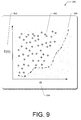
- FIG. 9 illustrates an example graph from a third phase 206 (discussed at high level above) to identify a set of skylines from the model to represent a portion of the urban area.
- the area computing application 114 built a matrix of regions, M and now selects the pairs of regions having the number of transitions above an average from the matrix M.
- the area computing application 114 locates “a skyline set” represented by (L) from the selected region pairs according to the expected travel speed E(V) 802 and the ratio ⁇ 804 .
- a skyline is defined as points which are not dominated by any other points. For instance, a point dominates another point if the point is as good or better in all dimensions and better in at least one dimension than the another point.
- An example process illustrates how the area computing application 114 determines when a first point dominates a second point if the first point is as good or better in all dimensions and better in at least one dimension than the second point. Points are shown in Table II along with expected travel speed E(V), and ratio ⁇ between the actual travel distance and the Euclidan distance between centroids of each of the pair of regions.
- Table II indicates that point 2 dominates point 1 based on the lower E(V) value and higher ratio. Thus, point 1 is not included in the skyline. However, point 2 does not dominate point 3 as point 3 has a higher ratio, indicating point 3 is better than point 2. Also, points 5 and 8 are detected as not being dominated by other points and included in the skyline while points 4, 6, and 7 are dominated by other points.
- FIG. 9 further illustrates the expected travel speed E(V) 802 plotted along y-axis and the ratio ⁇ 804 plotted along x-axis.
- the dashed line 900 illustrates points representing the pair of regions 900 that have smaller expected travel speeds E(V) 802 and larger ratios ⁇ 804 than the other points 902 located in the skyline.
- Each tuple a i,j , L is not dominated by others, such as a p,q L M, in terms of the expected travel speed E(V) 802 and the ratio ⁇ 804 .
- FIG. 10 illustrates example kinds of pairs of regions detected in the set of skylines.
- the pairs of regions in the set of skylines may have properties of a small expected travel speed E(V) 802 between a set of transitions and a small ratio ⁇ 804 between an actual travel distance of the set of transitions and an Euclidan distance between centroids of each of the pair of regions.
- the properties here indicate the pairs of regions are connected with some direct routes, while a capacity of these routes is not sufficient as compared to the existing traffic between the two regions.
- the properties here further indicate the drivers may have no other options but to take ineffective routes for travelling between the two regions.
- the pairs of regions in the set of skylines may have properties of a small expected travel speed E(V) 802 between a set of transitions and a large ratio ⁇ 804 between an actual travel distance of the set of transitions and an Euclidan distance between centroids of each of the pair of regions.
- the properties here indicate drivers of the route oriented vehicles 118 have to take detours for travelling between two regions while these detours have congested traffic leading to a slow speed. This is one of the worst cases of the kinds of pairs of regions in the set of skylines.
- the pairs of regions in the set of skylines may have properties of a large expected travel speed E(V) 802 between a set of transitions and a large ratio ⁇ 804 between an actual travel distance of the set of transitions and an Euclidan distance between centroids of each of the pair of regions.
- the properties here indicate that the drivers of the route-oriented vehicles 118 take detours such as highways, which are fast when travelling between two regions.
- the expected travel speed E(V) 802 is not slow, the long distance may cost the drivers and current passengers in the route-oriented vehicles more time and gas.
- the area computing application 114 identifies the most salient pairs of regions that have flawed planning.
- the skyline is constructed from the pairs of regions having a large amount of traffic, as represented by the count of transitions
- the skyline generated is based on many travels of passengers and each expected travel speed E(V) 802 , ratio ⁇ 804 is calculated based on a large number of observations.
- FIG. 11 illustrates an example process 1100 of formulating skyline graphs based on the pairs of regions connected from consecutive time slots. Shown along the left side are time periods of slot 1, slot 2, and slot 3 at 1102 . Table I. previously illustrated how the time slots correspond to different hours based on whether the day is a weekday or a weekend or holiday. Shown along the top are days, DAY 1, DAY 2, DAY 3 at 1104 .
- the process 1100 identifies a skyline in each time slot 1102 of each day 1104 . For instance, two pairs or regions from two consecutive slots may be connected if the pairs of regions are spatially close to each other. For example, in DAY 1, the process 1100 connects the pairs of regions r 1 ⁇ r 2 from slot 1 at 1106 to r 2 ⁇ r 8 from slot 2 at 1108 since the two pairs of regions share a common node of r 2 and appear in the consecutive time slots of the same day. Also, for DAY 1, the process 1100 connects r 4 ⁇ r 5 from slot 1 at 1110 to r 5 ⁇ r 7 from slot 2 at 1112 .
- the process 1100 does not connect r 4 ⁇ r 5 from slot 1 at 1100 to r 8 ⁇ r 4 from slot 3 at 1114 since the pairs of regions are not temporally close.
- the process 1100 then formulates a collection of skyline graphs (CG) 1116 .
- the area computing application 114 mines frequent sub-graph patterns from the collection of skyline graphs across a certain number of days to avoid any false alter. In certain instances, the area computing application 114 may detect a pair of regions with effective connectivity as part of a skyline based on anomaly events, such as a traffic accident. The mining of frequent sub-graph patterns further provides deeper analysis of any flaws in the urban area.
- the area computing application 114 mines the skyline patterns by utilizing different supports.
- the area computing application 114 calculates a support of a sub-graph pattern using the following equation:
- ⁇ ( g ) ⁇ ⁇ G ⁇ ⁇ g ⁇ G , CG ⁇ ⁇ num ⁇ ⁇ of ⁇ ⁇ days
- g represents the sub-graph pattern
- G is a skyline graph
- CG represents a collection of skyline graphs across multiple days.
- the denominator denotes the number of days that the dataset is analyzed over.
- the support of r 4 ⁇ r 5 is 1 since this transition appears in the skyline graphs of all three days while that of r 3 ⁇ r 6 is 2 ⁇ 3 since it only appears in DAY 2 and DAY 3.
- the area computing application 114 selects the support ⁇ .
- the patterns represent flaws present in the planning of the urban area, in which the patterns appear prominent and frequent.
- FIG. 12 illustrates examples of mined frequent skyline patterns at 1200 and 1202 .
- the area computing application 114 associates individual pairs of regions to determine any causalities and/or relationships among the regions to better understand how a problem may be derived.
- the area computing application 114 mines association rules among the patterns according to the following equations for support and confidence:
- Two patterns may formulate an association rule, denoted as g 1 ⁇ g 2 , if the support of g 1 ⁇ g 2 ⁇ and the confidence ⁇ (i.e., a given threshold).
- the association rules illustrate (r 4 ⁇ r 5 ) at 1204 ⁇ (r 3 ⁇ r 6 ) at 1206 which includes a support of 2 ⁇ 3 and a confidence of 2 ⁇ 3.
- (r 3 ⁇ r 6 ) at 1206 ⁇ (r 4 ⁇ r 5 ) at 1204 which includes a support of and a confidence of 1.
- the association rules may include two or more patterns. For instance, g 1 , g 2 ⁇ g 3 , where g 3 has a very high probability (conditioned by ⁇ and ⁇ ) to occur when g 1 and g 2 appear simultaneously.
- the sub-graph patterns may not be geospatially close to each other, revealing the causality and correlation between flawed planning without any relationship in the geographical spaces.
- the planning service 106 presents the user interface 110 on the display of the computing device 102 , after the user 108 activates the planning service 106 .
- the user interface 110 gives the user 108 access to the area computing application 114 provided by the planning service 106 .
- the user input may be for a request for a particular urban area to evaluate flaws in the planning.
- the planning service 106 accesses the model constructed from analysis of the logs of the route-oriented vehicles 118 .
- the construction of the model was previously described with reference to FIGS. 4-8 .
- FIG. 13 is an example heat map 1300 as computed by the area computing application 114 and presented to the user 108 on the user interface 110 .
- the area computing application 114 from the planning service 106 may be provided by a network service provider, a web application, an application based on a live search map, an application stored in memory of a computing device, and the like.
- the heat map 1300 represents the flaws in the urban area based on detecting the frequent sub-graph patterns.
- the heat map 1300 includes frequency that a region has been detected as a flaw.
- a shape represents different frequency levels of flaws in the regions.
- a square represents a smallest level of frequency of flaws 1302 for the regions shown with the squares
- a circle represents a small level of frequency of flaws 1304 for the regions shown with the circles.
- a star represents a middle level of frequency of flaws 1306 for the regions shown with the stars and a triangle represents a high level of frequency of flaws 1308 for the regions with the triangles.
- arrows may be used to indicate the direction of the transition from one region to another region.
- the recommendations may include building new roads, widening existing roads, converting roads to one way streets, adding new roads, adding local businesses such as shopping malls in the regions outsourcing people (i.e., land-use planning), adding subways or bus routes in these regions.
- FIG. 14 is a block diagram showing an example server 112 to be used for the planning service 106 and/or the area computing application 114 .
- the area computing server 112 may be configured as any suitable system capable of services, which includes, but is not limited to, implementing the planning service 106 for evaluating the planning of urban areas, such as provide the map of the urban area with flaws in the urban area due to traffic congestion, insufficient number of roads travelling through the regions, insufficient number of lanes on existing roads, insufficient land use, and the like.
- the server 112 comprises at least one processor 1400 , a memory 1402 , and a communication connection(s) 1404 .
- the processor(s) 1400 may be implemented as appropriate in hardware, software, firmware, or combinations thereof.
- Software or firmware implementations of the processor(s) 1400 may include computer-executable or machine-executable instructions written in any suitable programming language to perform the various functions described.
- memory 1402 may store program instructions that are loadable and executable on the processor(s) 1400 , as well as data generated during the execution of these programs.
- memory 1402 may be volatile (such as random access memory (RAM)) and/or non-volatile (such as read-only memory (ROM), flash memory, etc.).
- RAM random access memory
- ROM read-only memory
- memory 1402 includes volatile and nonvolatile, removable and non-removable media implemented in any method or technology for storage of information, such as computer-readable instructions, data structures, program modules, or other data.
- the communication connection(s) 1404 may include access to a wide area network (WAN) module, a local area network module (e.g., WiFi), a personal area network module (e.g., Bluetooth), and/or any other suitable communication modules to allow the area computing server 112 to communicate over the network(s) 104 .
- WAN wide area network
- WiFi local area network
- Bluetooth personal area network module
- the memory 1402 may store an operating system 1406 , the planning service module 106 , the area computing application module 114 , and one or more applications 1408 for implementing all or a part of applications and/or services using the planning service 106 .
- the one or more other applications 1408 may include an email application, online services, a calendar application, a navigation module, a game, and the like.
- the memory 1402 in this implementation may also include a model of traffic patterns and connectivity module 1410 and a skyline graph module 1412 .
- the area computing application module 114 may perform the operations described with reference to the figures or in combination with the planning service module 106 , the model of traffic patterns and connectivity module 1410 , and the skyline graph module 1412 .
- the server 112 may include the database 116 to store the collection of GPS logs, trajectories, graphs, routes, models, maps of urban areas, and the like. Alternatively, this information may be stored on other databases.
- the server 112 may also include additional removable storage 1414 and/or non-removable storage 1418 including, but not limited to, magnetic storage, optical disks, and/or tape storage.
- the disk drives and their associated computer-readable media may provide non-volatile storage of computer readable instructions, data structures, program modules, and other data for the computing devices.
- the memory 1402 may include multiple different types of memory, such as static random access memory (SRAM), dynamic random access memory (DRAM), or ROM.
- Computer-readable media includes, at least, two types of computer-readable media, namely computer storage media and communications media.
- Computer storage media includes volatile and non-volatile, removable and non-removable media implemented in any method or technology for storage of information such as computer readable instructions, data structures, program modules, or other data.
- Computer storage media includes, but is not limited to, RAM, ROM, erasable programmable read-only memory (EEPROM), flash memory or other memory technology, compact disc read-only memory (CD-ROM), digital versatile disks (DVD) or other optical storage, magnetic cassettes, magnetic tape, magnetic disk storage or other magnetic storage devices, or any other non-transmission medium that can be used to store information for access by a computing device.
- communication media may embody computer readable instructions, data structures, program modules, or other data in a modulated data signal, such as a carrier wave, or other transmission mechanism.
- computer storage media does not include communication media.
- Various instructions, methods, techniques, applications, and modules described herein may be implemented as computer-executable instructions that are executable by one or more computers, servers, or computing devices.
- program modules include routines, programs, objects, components, data structures, etc. for performing particular tasks or implementing particular abstract data types.
- These program modules and the like may be executed as native code or may be downloaded and executed, such as in a virtual machine or other just-in-time compilation execution environment.
- the functionality of the program modules may be combined or distributed as desired in various implementations.
- An implementation of these modules and techniques may be stored on or transmitted across some form of computer-readable storage media.
- the server 112 as described above may be implemented in various types of systems or networks.
- the server may be a part of, including but is not limited to, a client-server system, a peer-to-peer computer network, a distributed network, an enterprise architecture, a local area network, a wide area network, a virtual private network, a storage area network, and the like.
Abstract
Description
| TABLE I |
| Time Partition for Weekdays and Weekends/Holidays |
| Time | Weekdays | Weekends/ | ||
| Slot | ||||
| 1 | 7:00 am-10:30 am | 9:00 am-12:30 | ||
| Slot | ||||
| 2 | 10:30 am-4:00 pm | 12:30 pm-7:30 | ||
| Slot | ||||
| 3 | 4:00 pm-7:30 pm | 7:30 pm-9:00 | ||
| Slot | ||||
| 4 | 7:30 pm-7:00 am | |||
d(p i ,p j)=Σi≦k<jDist(p k ,p k+1)
where Dist(pk, pk+1) denotes the Euclidian distance between two consecutive GPS points.
v=d(p i p j)/|p j ·t−p i ·t|
where t represents time. Examples of charts illustrating the speeds of the route-oriented
where S is a collection of transitions between r1 and r2. An example graph illustrating expected travel speed E(V), expected actual travel distance E(D), and ratio Θ is shown in
Example Map of Partitioned Urban Area into Regions
| TABLE II |
| Identifying GPS Points for Skyline |
| Expected Travel | ||
| Point | Speed E(V) | |
| 1 | 24 | 1.6 |
| 2 | 20 | 2.4 |
| 3 | 30 | 2.8 |
| 4 | 22 | 2.0 |
| 5 | 18 | 1.4 |
| 6 | 34 | 2.4 |
| 7 | 30 | 2.0 |
| 8 | 36 | 3.2 |
where g represents the sub-graph pattern, G is a skyline graph, and CG represents a collection of skyline graphs across multiple days. The denominator denotes the number of days that the dataset is analyzed over.
where |g1∪g2| denotes the number of days that g1 and g2 both occurred and |g1| indicates the number of days having g1.
Claims (20)
Priority Applications (1)
| Application Number | Priority Date | Filing Date | Title |
|---|---|---|---|
| US13/324,758 US9754226B2 (en) | 2011-12-13 | 2011-12-13 | Urban computing of route-oriented vehicles |
Applications Claiming Priority (1)
| Application Number | Priority Date | Filing Date | Title |
|---|---|---|---|
| US13/324,758 US9754226B2 (en) | 2011-12-13 | 2011-12-13 | Urban computing of route-oriented vehicles |
Publications (2)
| Publication Number | Publication Date |
|---|---|
| US20130151297A1 US20130151297A1 (en) | 2013-06-13 |
| US9754226B2 true US9754226B2 (en) | 2017-09-05 |
Family
ID=48572860
Family Applications (1)
| Application Number | Title | Priority Date | Filing Date |
|---|---|---|---|
| US13/324,758 Active US9754226B2 (en) | 2011-12-13 | 2011-12-13 | Urban computing of route-oriented vehicles |
Country Status (1)
| Country | Link |
|---|---|
| US (1) | US9754226B2 (en) |
Cited By (6)
| Publication number | Priority date | Publication date | Assignee | Title |
|---|---|---|---|---|
| US10169529B2 (en) * | 2014-11-28 | 2019-01-01 | International Business Machines Corporation | Method and apparatus for determining a road network partitioning border line |
| US10621228B2 (en) | 2011-06-09 | 2020-04-14 | Ncm Ip Holdings, Llc | Method and apparatus for managing digital files |
| US11209968B2 (en) | 2019-01-07 | 2021-12-28 | MemoryWeb, LLC | Systems and methods for analyzing and organizing digital photos and videos |
| US11256860B2 (en) * | 2018-09-13 | 2022-02-22 | FinancialForce.com, Inc. | Service provider server-based architecture for server-suggested data |
| US11778089B2 (en) | 2017-12-22 | 2023-10-03 | Certinia Inc. | Method and apparatus for generating records from communication data |
| US11954301B2 (en) | 2021-11-19 | 2024-04-09 | MemoryWeb. LLC | Systems and methods for analyzing and organizing digital photos and videos |
Families Citing this family (6)
| Publication number | Priority date | Publication date | Assignee | Title |
|---|---|---|---|---|
| US8015144B2 (en) | 2008-02-26 | 2011-09-06 | Microsoft Corporation | Learning transportation modes from raw GPS data |
| US9727669B1 (en) * | 2012-07-09 | 2017-08-08 | Google Inc. | Analyzing and interpreting user positioning data |
| JPWO2020116030A1 (en) * | 2018-12-03 | 2021-10-07 | 日本電気株式会社 | Road monitoring systems, road monitoring devices, road monitoring methods, and programs |
| CN110705827B (en) * | 2019-09-04 | 2022-06-10 | 北京航空航天大学 | Urban traffic health index establishing method based on traffic cloud |
| CN113409574B (en) * | 2021-06-18 | 2022-08-02 | 北京航空航天大学 | Bayesian network-based traffic health diagnosis method |
| CN117238141B (en) * | 2023-11-14 | 2024-02-02 | 交通运输部规划研究院 | Cross-region travel behavior identification method and device of target vehicle and electronic equipment |
Citations (255)
| Publication number | Priority date | Publication date | Assignee | Title |
|---|---|---|---|---|
| US5428546A (en) | 1992-10-16 | 1995-06-27 | Mobile Information Systems | Method and apparatus for tracking vehicle location |
| US5802492A (en) | 1994-06-24 | 1998-09-01 | Delorme Publishing Company, Inc. | Computer aided routing and positioning system |
| US5845227A (en) * | 1991-02-01 | 1998-12-01 | Peterson; Thomas D. | Method and apparatus for providing shortest elapsed time route and tracking information to users |
| US5904727A (en) | 1995-05-17 | 1999-05-18 | Mobile Information Systems, Inc. | Graphical fleet management methods |
| US6023241A (en) | 1998-11-13 | 2000-02-08 | Intel Corporation | Digital multimedia navigation player/recorder |
| US6091359A (en) | 1997-07-14 | 2000-07-18 | Motorola, Inc. | Portable dead reckoning system for extending GPS coverage |
| US6091956A (en) * | 1997-06-12 | 2000-07-18 | Hollenberg; Dennis D. | Situation information system |
| US6122628A (en) | 1997-10-31 | 2000-09-19 | International Business Machines Corporation | Multidimensional data clustering and dimension reduction for indexing and searching |
| US6128279A (en) | 1997-10-06 | 2000-10-03 | Web Balance, Inc. | System for balancing loads among network servers |
| EP1087602A2 (en) | 1999-09-24 | 2001-03-28 | Cedardell Limited | Alarm system |
| EP1087605A2 (en) | 1999-09-17 | 2001-03-28 | Sony Corporation | Information processing apparatus and method , and program storage medium |
| US6219662B1 (en) | 1997-07-10 | 2001-04-17 | International Business Machines Corporation | Supporting database indexes based on a generalized B-tree index |
| US6243647B1 (en) | 1999-01-28 | 2001-06-05 | International Business Machines Corporation | Three dimensional display for time multiplexed global positioning system cell location beacon system |
| US20010029425A1 (en) | 2000-03-17 | 2001-10-11 | David Myr | Real time vehicle guidance and traffic forecasting system |
| US6317686B1 (en) | 2000-07-21 | 2001-11-13 | Bin Ran | Method of providing travel time |
| US6317684B1 (en) | 1999-12-22 | 2001-11-13 | At&T Wireless Services Inc. | Method and apparatus for navigation using a portable communication device |
| US6351775B1 (en) | 1997-05-30 | 2002-02-26 | International Business Machines Corporation | Loading balancing across servers in a computer network |
| US6356838B1 (en) | 2000-07-25 | 2002-03-12 | Sunil Paul | System and method for determining an efficient transportation route |
| US20020032689A1 (en) | 1999-12-15 | 2002-03-14 | Abbott Kenneth H. | Storing and recalling information to augment human memories |
| US20020038360A1 (en) | 2000-05-31 | 2002-03-28 | Matthew Andrews | System and method for locating a closest server in response to a client domain name request |
| US20020044690A1 (en) | 2000-10-18 | 2002-04-18 | Burgess Ken L. | Method for matching geographic information with recorded images |
| US20020052873A1 (en) | 2000-07-21 | 2002-05-02 | Joaquin Delgado | System and method for obtaining user preferences and providing user recommendations for unseen physical and information goods and services |
| US6385539B1 (en) | 1999-08-13 | 2002-05-07 | Daimlerchrysler Ag | Method and system for autonomously developing or augmenting geographical databases by mining uncoordinated probe data |
| JP2002140362A (en) | 2000-10-31 | 2002-05-17 | Toshiba Corp | System and method for providing information to moving body |
| US20020062193A1 (en) | 2000-09-26 | 2002-05-23 | Ching-Fang Lin | Enhanced inertial measurement unit/global positioning system mapping and navigation process |
| US20020077749A1 (en) | 2000-12-15 | 2002-06-20 | Miwako Doi | Walker navigation system, walker navigation method, guidance data collection apparatus and guidance data collection method |
| US6411897B1 (en) | 2000-07-10 | 2002-06-25 | Iap Intermodal, Llc | Method to schedule a vehicle in real-time to transport freight and passengers |
| US6424370B1 (en) | 1999-10-08 | 2002-07-23 | Texas Instruments Incorporated | Motion based event detection system and method |
| US6427122B1 (en) | 2000-12-23 | 2002-07-30 | American Gnc Corporation | Positioning and data integrating method and system thereof |
| US6430547B1 (en) | 1999-09-22 | 2002-08-06 | International Business Machines Corporation | Method and system for integrating spatial analysis and data mining analysis to ascertain relationships between collected samples and geology with remotely sensed data |
| US6446121B1 (en) | 1998-05-26 | 2002-09-03 | Cisco Technology, Inc. | System and method for measuring round trip times in a network using a TCP packet |
| US20020128768A1 (en) | 2001-03-09 | 2002-09-12 | Nobuyuki Nakano | Route guide information distributing system |
| JP2002304408A (en) | 2001-04-04 | 2002-10-18 | Hitachi Ltd | Mobile terminal |
| US6493650B1 (en) | 2000-01-27 | 2002-12-10 | Optimus Corporation | Device for automatic documentation of crash scenes |
| US6496814B1 (en) | 2000-07-19 | 2002-12-17 | International Business Machines Corporation | Method and system for integrating spatial analysis, and scheduling to efficiently schedule and monitor infrastructure maintenance |
| US6513026B1 (en) | 2000-06-17 | 2003-01-28 | Microsoft Corporation | Decision theoretic principles and policies for notification |
| JP2003044503A (en) | 2001-07-27 | 2003-02-14 | Sharp Corp | System, device and method for providing information |
| US20030053424A1 (en) | 2001-08-07 | 2003-03-20 | Srikanth Krishnamurthy | Method and apparatus for determining position and trajectory of gateways to optimize performance in hybrid non-terrestrial-terrestrial multi-hop mobile networks |
| US20030063133A1 (en) | 2001-09-28 | 2003-04-03 | Fuji Xerox Co., Ltd. | Systems and methods for providing a spatially indexed panoramic video |
| US20030069893A1 (en) | 2000-03-29 | 2003-04-10 | Kabushiki Kaisha Toshiba | Scheme for multimedia data retrieval using event names and time/location information |
| US20030069968A1 (en) | 1998-10-01 | 2003-04-10 | O'neil Kevin M. | System for balancing loads among network servers |
| US6553310B1 (en) | 2000-11-14 | 2003-04-22 | Hewlett-Packard Company | Method of and apparatus for topologically based retrieval of information |
| US6584401B2 (en) | 2001-11-27 | 2003-06-24 | Hewlett-Packard Development Company, Lp. | Automatic gathering and analysis of data on commute paths |
| US20030140040A1 (en) | 2001-12-21 | 2003-07-24 | Andrew Schiller | Method for analyzing demographic data |
| US20030139898A1 (en) | 2002-01-23 | 2003-07-24 | Miller Daniel Halvard | Method for synchronizing operation across devices |
| US6606643B1 (en) | 2000-01-04 | 2003-08-12 | International Business Machines Corporation | Method of automatically selecting a mirror server for web-based client-host interaction |
| US6611881B1 (en) | 2000-03-15 | 2003-08-26 | Personal Data Network Corporation | Method and system of providing credit card user with barcode purchase data and recommendation automatically on their personal computer |
| US6618507B1 (en) | 1999-01-25 | 2003-09-09 | Mitsubishi Electric Research Laboratories, Inc | Methods of feature extraction of video sequences |
| US6625319B1 (en) | 1999-03-30 | 2003-09-23 | Koninklijke Philips Electronics N.V. | Image compression using content-based image similarity |
| US20030195810A1 (en) | 2002-04-12 | 2003-10-16 | Sri Raghupathy | System and method for grouping products in a catalog |
| US20030212689A1 (en) | 2002-05-10 | 2003-11-13 | International Business Machines Corporation | Systems, methods and computer program products to improve indexing of multidimensional databases |
| US20030217070A1 (en) | 2002-04-15 | 2003-11-20 | Hideo Gotoh | Positional information management system, positional information management method, recording medium, and mobile terminal |
| US20030229697A1 (en) | 2002-06-10 | 2003-12-11 | 3Com Corporation | Method and apparatus for global server load balancing |
| US20040039798A1 (en) | 1999-03-03 | 2004-02-26 | Ultradns, Inc. | Domain name resolution system and method |
| US20040064338A1 (en) | 2002-09-27 | 2004-04-01 | Kazuo Shiota | Method, apparatus, and computer program for generating albums |
| US20040073640A1 (en) | 2002-09-23 | 2004-04-15 | Cricket Technologies Llc | Network load management apparatus, system, method, and electronically stored computer product |
| US6724733B1 (en) | 1999-11-02 | 2004-04-20 | Sun Microsystems, Inc. | Method and apparatus for determining approximate network distances using reference locations |
| US6732120B1 (en) | 1998-09-03 | 2004-05-04 | Geojet Information Solutions Inc. | System and method for processing and display of geographical data |
| US20040117358A1 (en) | 2002-03-16 | 2004-06-17 | Von Kaenel Tim A. | Method, system, and program for an improved enterprise spatial system |
| US6785704B1 (en) | 1999-12-20 | 2004-08-31 | Fastforward Networks | Content distribution system for operation over an internetwork including content peering arrangements |
| US20040198386A1 (en) | 2002-01-16 | 2004-10-07 | Dupray Dennis J. | Applications for a wireless location gateway |
| US20040196161A1 (en) * | 2003-04-01 | 2004-10-07 | International Business Machines Corporation | Wireless highway guide |
| US20040217884A1 (en) | 2003-04-30 | 2004-11-04 | Ramin Samadani | Systems and methods of viewing, modifying, and interacting with "path-enhanced" multimedia |
| US20040220965A1 (en) | 2003-04-30 | 2004-11-04 | Michael Harville | Indexed database structures and methods for searching path-enhanced multimedia |
| US6816779B2 (en) | 2002-02-15 | 2004-11-09 | International Business Machines Corporation | Programmatically computing street intersections using street geometry |
| US20040264465A1 (en) | 2002-11-27 | 2004-12-30 | Dunk Craig A. | Data transfer from a host server via a tunnel server to a wireless device, and associating a temporary ipv6 address with a temporary ipv4 address for communicating in an ipv4 wireless network with the device |
| US20050004830A1 (en) | 2003-07-03 | 2005-01-06 | Travelweb Llc | System and method for indexing travel accommodations in a network environment |
| US20050004903A1 (en) | 2002-03-15 | 2005-01-06 | Fujitsu Limited | Regional information retrieving method and regional information retrieval apparatus |
| US20050031296A1 (en) | 2003-07-24 | 2005-02-10 | Grosvenor David Arthur | Method and apparatus for reviewing video |
| US20050075784A1 (en) | 2003-10-07 | 2005-04-07 | Gray Sarah Ann | Modular path planner |
| US20050075116A1 (en) | 2003-10-01 | 2005-04-07 | Laird Mark D. | Wireless virtual campus escort system |
| US20050075782A1 (en) | 2002-02-21 | 2005-04-07 | Torgunrud John Arnold | Vehicle and traffic information processing system |
| US20050075119A1 (en) | 2002-04-10 | 2005-04-07 | Sheha Michael A. | Method and system for dynamic estimation and predictive route generation |
| USRE38724E1 (en) * | 1991-02-01 | 2005-04-12 | Peterson Thomas D | Method and apparatus for providing shortest elapsed time route and tracking information to users |
| US20050080554A1 (en) | 2003-03-27 | 2005-04-14 | Takashi Ono | Area information provision system and method |
| US20050108261A1 (en) | 2003-11-04 | 2005-05-19 | Joseph Glassy | Geodigital multimedia data processing system and method |
| US20050131889A1 (en) | 2003-12-11 | 2005-06-16 | International Business Machines Corporation | Intelligent data query builder |
| KR20050072555A (en) | 2004-01-07 | 2005-07-12 | 삼성전자주식회사 | System and method for providing predicted traffic information |
| US6919842B2 (en) | 2003-03-06 | 2005-07-19 | Samsung Electronics Co., Ltd. | Hybrid navigation system using neural network |
| US6925447B2 (en) | 2000-02-04 | 2005-08-02 | Medtronic, Inc. | Responsive manufacturing and inventory control |
| US20050198286A1 (en) | 2004-01-30 | 2005-09-08 | Zhichen Xu | Selecting nodes close to another node in a network using location information for the nodes |
| US20050203927A1 (en) | 2000-07-24 | 2005-09-15 | Vivcom, Inc. | Fast metadata generation and delivery |
| US20050225678A1 (en) | 2004-04-08 | 2005-10-13 | Andrew Zisserman | Object retrieval |
| US20050231394A1 (en) | 2004-02-25 | 2005-10-20 | Hitachi, Ltd. | Traffic information display apparatus |
| US6965827B1 (en) | 2000-10-30 | 2005-11-15 | Board Of Trustees Of The University Of Illinois | Method and system for tracking moving objects |
| US6970884B2 (en) | 2001-08-14 | 2005-11-29 | International Business Machines Corporation | Methods and apparatus for user-centered similarity learning |
| US20050265317A1 (en) | 2004-05-07 | 2005-12-01 | Zeus Technology Limited | Managing the flow of data traffic |
| US20050278371A1 (en) | 2004-06-15 | 2005-12-15 | Karsten Funk | Method and system for georeferential blogging, bookmarking a location, and advanced off-board data processing for mobile systems |
| US6981055B1 (en) | 2000-08-22 | 2005-12-27 | Internap Network Services Corporation | Method and system for optimizing routing through multiple available internet route providers |
| KR20060006271A (en) | 2004-07-15 | 2006-01-19 | 에스케이 텔레콤주식회사 | Method for furnishing the gis data using pedestrian path and subway route in mobile network |
| US20060020597A1 (en) | 2003-11-26 | 2006-01-26 | Yesvideo, Inc. | Use of image similarity in summarizing a collection of visual images |
| US20060036630A1 (en) | 2003-01-28 | 2006-02-16 | Microsoft Corporation | System and process for identifying objects and/or points nearby a given object or point |
| US7003555B1 (en) | 2000-06-23 | 2006-02-21 | Cloudshield Technologies, Inc. | Apparatus and method for domain name resolution |
| US20060042483A1 (en) | 2004-09-02 | 2006-03-02 | Work James D | Method and system for reputation evaluation of online users in a social networking scheme |
| US7013290B2 (en) | 2001-08-03 | 2006-03-14 | John Allen Ananian | Personalized interactive digital catalog profiling |
| US7013517B2 (en) | 2002-12-13 | 2006-03-21 | Maytag Corp. | Rotating/tipping agitator for a washing machine |
| US7031517B1 (en) | 1998-10-02 | 2006-04-18 | Canon Kabushiki Kaisha | Method and apparatus for segmenting images |
| US20060085419A1 (en) | 2004-10-19 | 2006-04-20 | Rosen James S | System and method for location based social networking |
| US20060085177A1 (en) | 2004-10-19 | 2006-04-20 | Microsoft Corporation | Modeling location histories |
| US20060090122A1 (en) | 2004-10-21 | 2006-04-27 | Nokia Corporation | Group editing of media content stored on wireless portable devices |
| US20060095540A1 (en) | 2004-11-01 | 2006-05-04 | Anderson Eric C | Using local networks for location information and image tagging |
| US20060101377A1 (en) | 2004-10-19 | 2006-05-11 | Microsoft Corporation | Parsing location histories |
| US7062562B1 (en) | 2001-04-11 | 2006-06-13 | Cisco Technology, Inc. | Methods and apparatus for content server selection |
| US20060129675A1 (en) | 2004-11-22 | 2006-06-15 | Intel Corporation | System and method to reduce platform power utilization |
| GB2421653A (en) | 2004-12-24 | 2006-06-28 | Trek Wireless Ltd | System for the collection and association of image and position data |
| US20060143442A1 (en) | 2004-12-24 | 2006-06-29 | Smith Sander A | Automated issuance of SSL certificates |
| US20060149464A1 (en) | 2004-12-31 | 2006-07-06 | Huan-Wen Chien | Method and system for determining the shortest elapsed time route |
| US20060155464A1 (en) | 2004-11-30 | 2006-07-13 | Circumnav Networks, Inc. | Methods and systems for deducing road geometry and connectivity |
| US20060156209A1 (en) | 2003-02-25 | 2006-07-13 | Satoshi Matsuura | Application program prediction method and mobile terminal |
| US20060161560A1 (en) | 2005-01-14 | 2006-07-20 | Fatlens, Inc. | Method and system to compare data objects |
| US20060164238A1 (en) | 2005-01-26 | 2006-07-27 | Jeyhan Karaoguz | GPS enabled cell phone with common interest alerts |
| US20060173838A1 (en) | 2005-01-31 | 2006-08-03 | France Telecom | Content navigation service |
| US20060178807A1 (en) | 2004-09-10 | 2006-08-10 | Xanavi Informatics Corporation | Apparatus and method for processing and displaying traffic information in an automotive navigation system |
| US20060190602A1 (en) | 2005-02-23 | 2006-08-24 | At&T Corp. | Monitoring for replica placement and request distribution |
| US20060200539A1 (en) | 2005-03-03 | 2006-09-07 | Kappler Elizabeth M | Determining a boot server network address from which to download an operating system during a boot sequence |
| US7111061B2 (en) | 2000-05-26 | 2006-09-19 | Akamai Technologies, Inc. | Global load balancing across mirrored data centers |
| WO2006097907A2 (en) | 2005-03-18 | 2006-09-21 | Koninklijke Philips Electronics, N.V. | Video diary with event summary |
| US20060212217A1 (en) | 2004-10-01 | 2006-09-21 | Networks In Motion, Inc. | Method and system for enabling an off board navigation solution |
| US20060224303A1 (en) | 2005-03-30 | 2006-10-05 | Denso Corporation | Navigation system and program for the same |
| US20060224773A1 (en) | 2005-03-31 | 2006-10-05 | International Business Machines Corporation | Systems and methods for content-aware load balancing |
| US20060247844A1 (en) * | 2005-04-27 | 2006-11-02 | Irving Wang | Intelligent traffic monitoring and guidance system |
| US20060251292A1 (en) | 2005-05-09 | 2006-11-09 | Salih Burak Gokturk | System and method for recognizing objects from images and identifying relevancy amongst images and information |
| US7136932B1 (en) | 1999-03-22 | 2006-11-14 | Eric Schneider | Fictitious domain name method, product, and apparatus |
| US20060265125A1 (en) | 2005-05-23 | 2006-11-23 | General Motors Corporation | Method and system for selecting route guidance data for off-board navigation |
| KR100650389B1 (en) | 2005-11-10 | 2006-11-29 | 성균관대학교산학협력단 | Indexing system of moving objects using time-based partitioning with second-dimensional structure and method thereof |
| US20060266830A1 (en) | 2005-05-31 | 2006-11-30 | Horozov Tzvetan T | Location-based recommendation system |
| US7152118B2 (en) | 2002-02-25 | 2006-12-19 | Broadcom Corporation | System, method and computer program product for caching domain name system information on a network gateway |
| US20070005419A1 (en) | 2005-06-30 | 2007-01-04 | Microsoft Corporation | Recommending location and services via geospatial collaborative filtering |
| US20070006098A1 (en) | 2005-06-30 | 2007-01-04 | Microsoft Corporation | Integration of location logs, GPS signals, and spatial resources for identifying user activities, goals, and context |
| US20070016663A1 (en) | 2005-07-14 | 2007-01-18 | Brian Weis | Approach for managing state information by a group of servers that services a group of clients |
| WO2007010317A1 (en) * | 2005-07-22 | 2007-01-25 | Telargo Inc. | Method, device and system for modeling a road network graph |
| US7171415B2 (en) | 2001-05-04 | 2007-01-30 | Sun Microsystems, Inc. | Distributed information discovery through searching selected registered information providers |
| US20070038362A1 (en) | 2002-03-05 | 2007-02-15 | Triangle Software Llc | Traffic routing based on segment travel time |
| US20070041393A1 (en) | 2005-08-19 | 2007-02-22 | Microsoft Corporation | Branch office DNS storage and resolution |
| US7194552B1 (en) | 1999-03-22 | 2007-03-20 | Eric Schneider | Method, product, and apparatus for requesting a network resource |
| US20070064633A1 (en) | 2003-04-09 | 2007-03-22 | Volker Fricke | Method, systems and comuter program products for data logging |
| US20070064715A1 (en) | 2002-07-25 | 2007-03-22 | Avaya, Inc. | Method and apparatus for the assessment and optimization of network traffic |
| US7197500B1 (en) | 1996-10-25 | 2007-03-27 | Navteq North America, Llc | System and method for use and storage of geographic data on physical media |
| US7203693B2 (en) | 2001-06-12 | 2007-04-10 | Lucent Technologies Inc. | Instantly indexed databases for multimedia content analysis and retrieval |
| US20070088974A1 (en) | 2005-09-26 | 2007-04-19 | Intel Corporation | Method and apparatus to detect/manage faults in a system |
| US20070100776A1 (en) | 2003-07-31 | 2007-05-03 | Pritam Shah | Route optimization of services provided by one or more service providers for combined links |
| US7219067B1 (en) | 1999-09-10 | 2007-05-15 | Ge Harris Railway Electronics Llc | Total transportation management system |
| US20070118668A1 (en) | 2005-11-21 | 2007-05-24 | Limelight Networks, Inc. | Domain Name Resolution Resource Allocation |
| US7228359B1 (en) | 2002-02-12 | 2007-06-05 | Cisco Technology, Inc. | Methods and apparatus for providing domain name service based on a client identifier |
| US20070127833A1 (en) | 2005-11-30 | 2007-06-07 | Singh Munindar P | Automatic Generation Of Metadata For A Digital Image Based On Ambient Conditions |
| US7233861B2 (en) | 2003-12-08 | 2007-06-19 | General Motors Corporation | Prediction of vehicle operator destinations |
| US7239962B2 (en) | 2003-02-21 | 2007-07-03 | Sony Corporation | Method and apparatus for a routing agent |
| US20070168208A1 (en) | 2005-12-13 | 2007-07-19 | Ville Aikas | Location recommendation method and system |
| WO2007087615A2 (en) | 2006-01-25 | 2007-08-02 | Redzone Robotics, Inc. | Spatio-temporal and context-based indexing and representation of subterranean networks and means for doing same |
| US20070203638A1 (en) | 2006-02-28 | 2007-08-30 | Aisin Aw Co., Ltd. | Navigation system |
| US20070226004A1 (en) | 2001-06-01 | 2007-09-27 | Landnet Corporation | Identification, storage and display of land data on a website |
| US7281199B1 (en) | 1999-04-14 | 2007-10-09 | Verizon Corporate Services Group Inc. | Methods and systems for selection of multimedia presentations |
| US7284051B1 (en) | 1998-12-28 | 2007-10-16 | Fujitsu Limited | Relaying apparatus for use in a network system |
| WO2007145625A1 (en) | 2006-06-14 | 2007-12-21 | Lucent Technologies, Inc. | Dynamic route prediction based on travel patterns of mobile units |
| US20080004793A1 (en) | 2006-06-30 | 2008-01-03 | Microsoft Corporation | Computing and harnessing inferences about the timing, duration, and nature of motion and cessation of motion with applications to mobile computing and communications |
| US20080004789A1 (en) | 2006-06-30 | 2008-01-03 | Microsoft Corporation | Inferring road speeds for context-sensitive routing |
| US20080016051A1 (en) | 2001-12-21 | 2008-01-17 | Andrew Schiller | Method for analyzing demographic data |
| US20080016233A1 (en) | 1999-03-22 | 2008-01-17 | Eric Schneider | Methods, systems, products, and devices for processing dns friendly identifiers |
| US20080052303A1 (en) | 2002-05-10 | 2008-02-28 | International Business Machines Corporation | Reducing index size for multi-level grid indexes |
| US20080059576A1 (en) | 2006-08-31 | 2008-03-06 | Microsoft Corporation | Recommending contacts in a social network |
| US20080071465A1 (en) | 2006-03-03 | 2008-03-20 | Chapman Craig H | Determining road traffic conditions using data from multiple data sources |
| US7349768B2 (en) | 2005-04-25 | 2008-03-25 | The Boeing Company | Evacuation route planning tool |
| US20080076451A1 (en) | 2001-08-16 | 2008-03-27 | Networks In Motion, Inc. | Point of interest spatial rating search |
| US20080086574A1 (en) | 2006-10-05 | 2008-04-10 | Limelight Networks, Inc. | Remote Domain Name Service |
| US20080098313A1 (en) | 2006-10-23 | 2008-04-24 | Instabuddy Llc | System and method for developing and managing group social networks |
| US7366726B2 (en) | 2000-10-12 | 2008-04-29 | Qas Limited | Method and apparatus for retrieving data representing a postal address from a plurality of postal addresses |
| US7389283B2 (en) | 2004-12-07 | 2008-06-17 | International Business Machines Corporation | Method for determining an optimal grid index specification for multidimensional data |
| US7395250B1 (en) | 2000-10-11 | 2008-07-01 | International Business Machines Corporation | Methods and apparatus for outlier detection for high dimensional data sets |
| US20080201074A1 (en) | 2007-02-15 | 2008-08-21 | Garmin Ltd. | System and method for creating and sharing navigation routes with electronic devices |
| US20080201102A1 (en) | 2007-02-21 | 2008-08-21 | British Telecommunications | Method for capturing local and evolving clusters |
| US20080215237A1 (en) | 2006-05-17 | 2008-09-04 | International Business Machines Corporation | Design structure for adaptive route planning for gps-based navigation |
| US20080214157A1 (en) | 2005-09-14 | 2008-09-04 | Jorey Ramer | Categorization of a Mobile User Profile Based on Browse Behavior |
| US20080228396A1 (en) | 2007-03-16 | 2008-09-18 | Xanavi Informatics Corporation | System and method for updating a statistical database in a vehicle navigation system |
| US20080228783A1 (en) | 2007-03-14 | 2008-09-18 | Dawn Moffat | Data Partitioning Systems |
| US7428551B2 (en) | 2006-02-20 | 2008-09-23 | Linkage Technology Co., Ltd. | “Gird plus T Tree” index method for quick orientation in massive memory database |
| US20080235383A1 (en) | 2007-03-22 | 2008-09-25 | Eric Schneider | Methods, Systems, Products, And Devices For Generating And Processing DNS Friendly Identifiers |
| US7437239B2 (en) | 2002-01-09 | 2008-10-14 | Webraska Mobile Technologies | Method and device for determining the minimal cost path between two points in a road network |
| US7437372B2 (en) | 2002-05-10 | 2008-10-14 | International Business Machines Corporation | Systems, methods, and computer program products to reduce computer processing in grid cell size determination for indexing of multidimensional databases |
| US20080270019A1 (en) * | 2006-12-29 | 2008-10-30 | High Regard Software, Inc. | Systems and methods for enhancing private transportation |
| US20080268876A1 (en) | 2007-04-24 | 2008-10-30 | Natasha Gelfand | Method, Device, Mobile Terminal, and Computer Program Product for a Point of Interest Based Scheme for Improving Mobile Visual Searching Functionalities |
| US7447588B1 (en) | 2007-07-16 | 2008-11-04 | Wenshine Technology Ltd. | Method and system for partitioning a continental roadway network for an intelligent vehicle highway system |
| US20080312822A1 (en) | 2007-06-14 | 2008-12-18 | Peter Lucas | Location based point of interest navigation system |
| US20080319974A1 (en) | 2007-06-21 | 2008-12-25 | Microsoft Corporation | Mining geographic knowledge using a location aware topic model |
| US20080319660A1 (en) | 2007-06-25 | 2008-12-25 | Microsoft Corporation | Landmark-based routing |
| US20080319648A1 (en) | 2005-10-20 | 2008-12-25 | Poltorak Alexander I | Apparatus and method for providing travel information |
| US20090005987A1 (en) | 2007-04-27 | 2009-01-01 | Vengroff Darren E | Determining locations of interest based on user visits |
| US20090019181A1 (en) | 2007-07-11 | 2009-01-15 | Samsung Electronics Co., Ltd. | Method and System for Preventing Service Disruption of Internet Protocol (IP) Based Services Due To Domain Name Resolution Failures |
| US7479897B2 (en) | 2003-06-04 | 2009-01-20 | Daimler Ag | Curve rollover warning system for trucks |
| US7493294B2 (en) | 2003-11-28 | 2009-02-17 | Manyworlds Inc. | Mutually adaptive systems |
| US20090063646A1 (en) | 2007-09-04 | 2009-03-05 | Nixle, Llc | System and method for collecting and organizing popular near real-time data in a virtual geographic grid |
| US20090070035A1 (en) | 2007-09-06 | 2009-03-12 | Gm Global Technology Operations, Inc. | Method for Adaptively Constructing and Revising Road Maps |
| US20090083128A1 (en) | 2007-09-24 | 2009-03-26 | Introspective Solutions, Llc | Predicted variable analysis based on evaluation variables relating to site selection |
| US20090083237A1 (en) | 2007-09-20 | 2009-03-26 | Nokia Corporation | Method, Apparatus and Computer Program Product for Providing a Visual Search Interface |
| US7519690B1 (en) | 2002-02-28 | 2009-04-14 | Sprint Communications Company L.P. | Dynamically updateable parameters in integrated services hub |
| US20090100018A1 (en) | 2007-10-12 | 2009-04-16 | Jonathan Roberts | System and method for capturing, integrating, discovering, and using geo-temporal data |
| WO2009053411A1 (en) | 2007-10-26 | 2009-04-30 | Tomtom International B.V. | A method of creating map data |
| US7548936B2 (en) | 2005-01-12 | 2009-06-16 | Microsoft Corporation | Systems and methods to present web image search results for effective image browsing |
| US20090164516A1 (en) | 2007-12-21 | 2009-06-25 | Concert Technology Corporation | Method and system for generating media recommendations in a distributed environment based on tagging play history information with location information |
| US7561959B2 (en) | 2004-06-30 | 2009-07-14 | Nauteq North America, Llc | Method of collecting information for a geographic database for use with a navigation system |
| US7574508B1 (en) | 2002-08-07 | 2009-08-11 | Foundry Networks, Inc. | Canonical name (CNAME) handling for global server load balancing |
| US20090216704A1 (en) | 2008-02-26 | 2009-08-27 | Microsoft Corporation | Learning transportation modes from raw gps data |
| US20090216435A1 (en) | 2008-02-26 | 2009-08-27 | Microsoft Corporation | System for logging life experiences using geographic cues |
| US20090213844A1 (en) | 2008-02-22 | 2009-08-27 | Sage Connex, Llc | Telephony |
| US7584159B1 (en) | 2005-10-31 | 2009-09-01 | Amazon Technologies, Inc. | Strategies for providing novel recommendations |
| US7584301B1 (en) | 2004-05-06 | 2009-09-01 | Foundry Networks, Inc. | Host-level policies for global server load balancing |
| US20090222581A1 (en) | 2008-03-03 | 2009-09-03 | Microsoft Corporation | Internet location coordinate enhanced domain name system |
| US20090228198A1 (en) | 2008-03-07 | 2009-09-10 | Microsoft Corporation | Selecting landmarks in shortest path computations |
| US20090239552A1 (en) | 2008-03-24 | 2009-09-24 | Yahoo! Inc. | Location-based opportunistic recommendations |
| US7603233B2 (en) | 2006-10-16 | 2009-10-13 | Alpine Electronics, Inc. | Map matching method and apparatus for navigation system |
| US7610151B2 (en) | 2006-06-27 | 2009-10-27 | Microsoft Corporation | Collaborative route planning for generating personalized and context-sensitive routing recommendations |
| US20090282122A1 (en) | 2008-05-09 | 2009-11-12 | Locomatix Inc. | Location tracking optimizations |
| US20090326802A1 (en) | 2008-06-30 | 2009-12-31 | General Motors Corporation | Method and System to Calculate Historical Traffic Data |
| US20100004997A1 (en) | 2008-05-27 | 2010-01-07 | Chand Mehta | Methods and apparatus for generating user profile based on periodic location fixes |
| US20100027527A1 (en) | 2008-07-30 | 2010-02-04 | Yahoo! Inc. | System and method for improved mapping and routing |
| US7660441B2 (en) | 2004-07-09 | 2010-02-09 | Southern California, University | System and method for fusing geospatial data |
| US20100070171A1 (en) | 2006-09-14 | 2010-03-18 | University Of South Florida | System and Method for Real-Time Travel Path Prediction and Automatic Incident Alerts |
| US7685422B2 (en) | 2004-05-18 | 2010-03-23 | Kabushiki Kaisha Toshiba | Information processing apparatus, information processing method, and information processing program |
| US20100076968A1 (en) | 2008-05-27 | 2010-03-25 | Boyns Mark R | Method and apparatus for aggregating and presenting data associated with geographic locations |
| US20100082611A1 (en) | 2008-09-23 | 2010-04-01 | Yahoo! Inc. | Trajectory Data Surfacing System: Surfacing Useful and Relevant Entity Annotations |
| US20100111372A1 (en) | 2008-11-03 | 2010-05-06 | Microsoft Corporation | Determining user similarities based on location histories |
| US7739040B2 (en) | 2006-06-30 | 2010-06-15 | Microsoft Corporation | Computation of travel routes, durations, and plans over multiple contexts |
| US20100153292A1 (en) | 2008-12-11 | 2010-06-17 | Microsoft Corporation | Making Friend and Location Recommendations Based on Location Similarities |
| US7801842B2 (en) | 2005-04-04 | 2010-09-21 | Spadac Inc. | Method and system for spatial behavior modification based on geospatial modeling |
| US20100279616A1 (en) * | 2009-04-30 | 2010-11-04 | Cisco Technology, Inc. | Self-Optimizing Wireless Network Base Station |
| US7840407B2 (en) | 2006-10-13 | 2010-11-23 | Google Inc. | Business listing search |
| US20100312461A1 (en) * | 2009-06-08 | 2010-12-09 | Haynie Michael B | System and method for vitally determining position and position uncertainty of a railroad vehicle employing diverse sensors including a global positioning system sensor |
| US20110022299A1 (en) | 2009-07-21 | 2011-01-27 | Alpine Electronics, Inc. | Method and apparatus to search and process poi information |
| US20110029224A1 (en) | 2006-03-03 | 2011-02-03 | Inrix, Inc. | Assessing road traffic flow conditions using data obtained from mobile data sources |
| US7904530B2 (en) | 2008-01-29 | 2011-03-08 | Palo Alto Research Center Incorporated | Method and apparatus for automatically incorporating hypothetical context information into recommendation queries |
| US7920965B1 (en) | 2006-05-05 | 2011-04-05 | Mapquest, Inc. | Identifying a route configured to travel through multiple points of interest |
| US7930427B2 (en) | 2008-03-03 | 2011-04-19 | Microsoft Corporation | Client-side load balancing |
| US7948400B2 (en) | 2007-06-29 | 2011-05-24 | Microsoft Corporation | Predictive models of road reliability for traffic sensor configuration and routing |
| US20110130947A1 (en) | 2009-11-30 | 2011-06-02 | Basir Otman A | Traffic profiling and road conditions-based trip time computing system with localized and cooperative assessment |
| US7982635B2 (en) | 2006-04-27 | 2011-07-19 | Thinkware Systems Corporation | Method and system for displaying traveling-position of move object |
| US7984006B2 (en) | 2007-09-18 | 2011-07-19 | Palo Alto Research Center Incorporated | Learning a user's activity preferences from GPS traces and known nearby venues |
| US20110176000A1 (en) * | 2010-01-21 | 2011-07-21 | Utah State University | System and Method for Counting People |
| US20110184949A1 (en) | 2010-01-25 | 2011-07-28 | Jiebo Luo | Recommending places to visit |
| US20110191011A1 (en) * | 2010-02-01 | 2011-08-04 | Mcbride Kurtis | System and Method for Modeling and Optimizing the Performance of Transportation Networks |
| US20110191284A1 (en) | 2005-04-04 | 2011-08-04 | Dalton Jason R | Temporal-Influenced Geospatial Modeling System and Method |
| US20110208419A1 (en) * | 2010-02-25 | 2011-08-25 | International Business Machines Corporation | Route optimization |
| US8060462B2 (en) | 2006-08-28 | 2011-11-15 | Manyworlds, Inc. | Mutual interest inferencing system and method |
| US20110280453A1 (en) | 2004-07-09 | 2011-11-17 | Ching-Chien Chen | System and Method for Fusing Geospatial Data |
| US20120030064A1 (en) | 2004-05-20 | 2012-02-02 | Manyworlds, Inc. | Physiological-Responsive Recommender System and Device |
| US8117138B2 (en) | 2008-03-11 | 2012-02-14 | International Business Machines Corporation | Method and apparatus for location evaluation and site selection |
| US8190649B2 (en) | 2006-04-25 | 2012-05-29 | Google Inc. | Ranking and clustering of geo-located objects |
| US8219112B1 (en) | 2007-11-27 | 2012-07-10 | Google Inc. | Accuracy analysis of wireless base station location |
| US8275649B2 (en) | 2009-09-18 | 2012-09-25 | Microsoft Corporation | Mining life pattern based on location history |
| US20120256770A1 (en) | 2011-04-08 | 2012-10-11 | Peter Mitchell | System and method for providing vehicle and fleet profiles and presentations of trends |
| US8458298B2 (en) | 2008-03-03 | 2013-06-04 | Microsoft Corporation | Failover in an internet location coordinate enhanced domain name system |
| US20130166188A1 (en) | 2011-12-21 | 2013-06-27 | Microsoft Corporation | Determine Spatiotemporal Causal Interactions In Data |
| US8562439B2 (en) | 2004-03-11 | 2013-10-22 | Navteq B.V. | Geographic area templates for computer games |
| US8577380B2 (en) | 2011-05-02 | 2013-11-05 | Telefonica, S.A. | Method for an automatic identification of urban dense areas from cell phones records |
| US20140088791A1 (en) | 2012-09-12 | 2014-03-27 | International Business Machines Corporation | Solving traffic congestion using vehicle grouping |
| US9009177B2 (en) | 2009-09-25 | 2015-04-14 | Microsoft Corporation | Recommending points of interests in a region |
| US20170131110A1 (en) | 2010-06-04 | 2017-05-11 | Microsoft Technology Licensing, Llc | Searching similar trajectories by locations |
-
2011
- 2011-12-13 US US13/324,758 patent/US9754226B2/en active Active
Patent Citations (277)
| Publication number | Priority date | Publication date | Assignee | Title |
|---|---|---|---|---|
| US5845227A (en) * | 1991-02-01 | 1998-12-01 | Peterson; Thomas D. | Method and apparatus for providing shortest elapsed time route and tracking information to users |
| USRE38724E1 (en) * | 1991-02-01 | 2005-04-12 | Peterson Thomas D | Method and apparatus for providing shortest elapsed time route and tracking information to users |
| US5428546A (en) | 1992-10-16 | 1995-06-27 | Mobile Information Systems | Method and apparatus for tracking vehicle location |
| US5802492A (en) | 1994-06-24 | 1998-09-01 | Delorme Publishing Company, Inc. | Computer aided routing and positioning system |
| US5904727A (en) | 1995-05-17 | 1999-05-18 | Mobile Information Systems, Inc. | Graphical fleet management methods |
| US7197500B1 (en) | 1996-10-25 | 2007-03-27 | Navteq North America, Llc | System and method for use and storage of geographic data on physical media |
| US6351775B1 (en) | 1997-05-30 | 2002-02-26 | International Business Machines Corporation | Loading balancing across servers in a computer network |
| US6091956A (en) * | 1997-06-12 | 2000-07-18 | Hollenberg; Dennis D. | Situation information system |
| US6219662B1 (en) | 1997-07-10 | 2001-04-17 | International Business Machines Corporation | Supporting database indexes based on a generalized B-tree index |
| US6091359A (en) | 1997-07-14 | 2000-07-18 | Motorola, Inc. | Portable dead reckoning system for extending GPS coverage |
| US6128279A (en) | 1997-10-06 | 2000-10-03 | Web Balance, Inc. | System for balancing loads among network servers |
| US6122628A (en) | 1997-10-31 | 2000-09-19 | International Business Machines Corporation | Multidimensional data clustering and dimension reduction for indexing and searching |
| US6446121B1 (en) | 1998-05-26 | 2002-09-03 | Cisco Technology, Inc. | System and method for measuring round trip times in a network using a TCP packet |
| US6732120B1 (en) | 1998-09-03 | 2004-05-04 | Geojet Information Solutions Inc. | System and method for processing and display of geographical data |
| US20030069968A1 (en) | 1998-10-01 | 2003-04-10 | O'neil Kevin M. | System for balancing loads among network servers |
| US7031517B1 (en) | 1998-10-02 | 2006-04-18 | Canon Kabushiki Kaisha | Method and apparatus for segmenting images |
| US6023241A (en) | 1998-11-13 | 2000-02-08 | Intel Corporation | Digital multimedia navigation player/recorder |
| US7284051B1 (en) | 1998-12-28 | 2007-10-16 | Fujitsu Limited | Relaying apparatus for use in a network system |
| US6618507B1 (en) | 1999-01-25 | 2003-09-09 | Mitsubishi Electric Research Laboratories, Inc | Methods of feature extraction of video sequences |
| US6243647B1 (en) | 1999-01-28 | 2001-06-05 | International Business Machines Corporation | Three dimensional display for time multiplexed global positioning system cell location beacon system |
| US20040039798A1 (en) | 1999-03-03 | 2004-02-26 | Ultradns, Inc. | Domain name resolution system and method |
| US7136932B1 (en) | 1999-03-22 | 2006-11-14 | Eric Schneider | Fictitious domain name method, product, and apparatus |
| US7194552B1 (en) | 1999-03-22 | 2007-03-20 | Eric Schneider | Method, product, and apparatus for requesting a network resource |
| US20080016233A1 (en) | 1999-03-22 | 2008-01-17 | Eric Schneider | Methods, systems, products, and devices for processing dns friendly identifiers |
| US6625319B1 (en) | 1999-03-30 | 2003-09-23 | Koninklijke Philips Electronics N.V. | Image compression using content-based image similarity |
| US7281199B1 (en) | 1999-04-14 | 2007-10-09 | Verizon Corporate Services Group Inc. | Methods and systems for selection of multimedia presentations |
| US6385539B1 (en) | 1999-08-13 | 2002-05-07 | Daimlerchrysler Ag | Method and system for autonomously developing or augmenting geographical databases by mining uncoordinated probe data |
| US7219067B1 (en) | 1999-09-10 | 2007-05-15 | Ge Harris Railway Electronics Llc | Total transportation management system |
| EP1087605A2 (en) | 1999-09-17 | 2001-03-28 | Sony Corporation | Information processing apparatus and method , and program storage medium |
| US6430547B1 (en) | 1999-09-22 | 2002-08-06 | International Business Machines Corporation | Method and system for integrating spatial analysis and data mining analysis to ascertain relationships between collected samples and geology with remotely sensed data |
| EP1087602A2 (en) | 1999-09-24 | 2001-03-28 | Cedardell Limited | Alarm system |
| US6424370B1 (en) | 1999-10-08 | 2002-07-23 | Texas Instruments Incorporated | Motion based event detection system and method |
| US6724733B1 (en) | 1999-11-02 | 2004-04-20 | Sun Microsystems, Inc. | Method and apparatus for determining approximate network distances using reference locations |
| US7155456B2 (en) | 1999-12-15 | 2006-12-26 | Tangis Corporation | Storing and recalling information to augment human memories |
| US20020032689A1 (en) | 1999-12-15 | 2002-03-14 | Abbott Kenneth H. | Storing and recalling information to augment human memories |
| US6785704B1 (en) | 1999-12-20 | 2004-08-31 | Fastforward Networks | Content distribution system for operation over an internetwork including content peering arrangements |
| US6317684B1 (en) | 1999-12-22 | 2001-11-13 | At&T Wireless Services Inc. | Method and apparatus for navigation using a portable communication device |
| US6606643B1 (en) | 2000-01-04 | 2003-08-12 | International Business Machines Corporation | Method of automatically selecting a mirror server for web-based client-host interaction |
| US6493650B1 (en) | 2000-01-27 | 2002-12-10 | Optimus Corporation | Device for automatic documentation of crash scenes |
| US6925447B2 (en) | 2000-02-04 | 2005-08-02 | Medtronic, Inc. | Responsive manufacturing and inventory control |
| US6611881B1 (en) | 2000-03-15 | 2003-08-26 | Personal Data Network Corporation | Method and system of providing credit card user with barcode purchase data and recommendation automatically on their personal computer |
| US20010029425A1 (en) | 2000-03-17 | 2001-10-11 | David Myr | Real time vehicle guidance and traffic forecasting system |
| US6615130B2 (en) | 2000-03-17 | 2003-09-02 | Makor Issues And Rights Ltd. | Real time vehicle guidance and traffic forecasting system |
| US20030069893A1 (en) | 2000-03-29 | 2003-04-10 | Kabushiki Kaisha Toshiba | Scheme for multimedia data retrieval using event names and time/location information |
| US7111061B2 (en) | 2000-05-26 | 2006-09-19 | Akamai Technologies, Inc. | Global load balancing across mirrored data centers |
| US20020038360A1 (en) | 2000-05-31 | 2002-03-28 | Matthew Andrews | System and method for locating a closest server in response to a client domain name request |
| US6513026B1 (en) | 2000-06-17 | 2003-01-28 | Microsoft Corporation | Decision theoretic principles and policies for notification |
| US7003555B1 (en) | 2000-06-23 | 2006-02-21 | Cloudshield Technologies, Inc. | Apparatus and method for domain name resolution |
| US20060075139A1 (en) | 2000-06-23 | 2006-04-06 | Cloudshield Technologies, Inc. | Apparatus and method for domain name resolution |
| US6411897B1 (en) | 2000-07-10 | 2002-06-25 | Iap Intermodal, Llc | Method to schedule a vehicle in real-time to transport freight and passengers |
| US6496814B1 (en) | 2000-07-19 | 2002-12-17 | International Business Machines Corporation | Method and system for integrating spatial analysis, and scheduling to efficiently schedule and monitor infrastructure maintenance |
| US6317686B1 (en) | 2000-07-21 | 2001-11-13 | Bin Ran | Method of providing travel time |
| US20020052873A1 (en) | 2000-07-21 | 2002-05-02 | Joaquin Delgado | System and method for obtaining user preferences and providing user recommendations for unseen physical and information goods and services |
| US20050203927A1 (en) | 2000-07-24 | 2005-09-15 | Vivcom, Inc. | Fast metadata generation and delivery |
| US6356838B1 (en) | 2000-07-25 | 2002-03-12 | Sunil Paul | System and method for determining an efficient transportation route |
| US6981055B1 (en) | 2000-08-22 | 2005-12-27 | Internap Network Services Corporation | Method and system for optimizing routing through multiple available internet route providers |
| US20020062193A1 (en) | 2000-09-26 | 2002-05-23 | Ching-Fang Lin | Enhanced inertial measurement unit/global positioning system mapping and navigation process |
| US7395250B1 (en) | 2000-10-11 | 2008-07-01 | International Business Machines Corporation | Methods and apparatus for outlier detection for high dimensional data sets |
| US7366726B2 (en) | 2000-10-12 | 2008-04-29 | Qas Limited | Method and apparatus for retrieving data representing a postal address from a plurality of postal addresses |
| US6904160B2 (en) | 2000-10-18 | 2005-06-07 | Red Hen Systems, Inc. | Method for matching geographic information with recorded images |
| US20020044690A1 (en) | 2000-10-18 | 2002-04-18 | Burgess Ken L. | Method for matching geographic information with recorded images |
| US6965827B1 (en) | 2000-10-30 | 2005-11-15 | Board Of Trustees Of The University Of Illinois | Method and system for tracking moving objects |
| JP2002140362A (en) | 2000-10-31 | 2002-05-17 | Toshiba Corp | System and method for providing information to moving body |
| US6553310B1 (en) | 2000-11-14 | 2003-04-22 | Hewlett-Packard Company | Method of and apparatus for topologically based retrieval of information |
| US20020077749A1 (en) | 2000-12-15 | 2002-06-20 | Miwako Doi | Walker navigation system, walker navigation method, guidance data collection apparatus and guidance data collection method |
| US6516272B2 (en) | 2000-12-23 | 2003-02-04 | American Gnc Corporation | Positioning and data integrating method and system thereof |
| US6427122B1 (en) | 2000-12-23 | 2002-07-30 | American Gnc Corporation | Positioning and data integrating method and system thereof |
| US20020128768A1 (en) | 2001-03-09 | 2002-09-12 | Nobuyuki Nakano | Route guide information distributing system |
| JP2002304408A (en) | 2001-04-04 | 2002-10-18 | Hitachi Ltd | Mobile terminal |
| US7062562B1 (en) | 2001-04-11 | 2006-06-13 | Cisco Technology, Inc. | Methods and apparatus for content server selection |
| US7171415B2 (en) | 2001-05-04 | 2007-01-30 | Sun Microsystems, Inc. | Distributed information discovery through searching selected registered information providers |
| US20070226004A1 (en) | 2001-06-01 | 2007-09-27 | Landnet Corporation | Identification, storage and display of land data on a website |
| US7203693B2 (en) | 2001-06-12 | 2007-04-10 | Lucent Technologies Inc. | Instantly indexed databases for multimedia content analysis and retrieval |
| JP2003044503A (en) | 2001-07-27 | 2003-02-14 | Sharp Corp | System, device and method for providing information |
| US7013290B2 (en) | 2001-08-03 | 2006-03-14 | John Allen Ananian | Personalized interactive digital catalog profiling |
| US20030053424A1 (en) | 2001-08-07 | 2003-03-20 | Srikanth Krishnamurthy | Method and apparatus for determining position and trajectory of gateways to optimize performance in hybrid non-terrestrial-terrestrial multi-hop mobile networks |
| US6970884B2 (en) | 2001-08-14 | 2005-11-29 | International Business Machines Corporation | Methods and apparatus for user-centered similarity learning |
| US20080076451A1 (en) | 2001-08-16 | 2008-03-27 | Networks In Motion, Inc. | Point of interest spatial rating search |
| US20030063133A1 (en) | 2001-09-28 | 2003-04-03 | Fuji Xerox Co., Ltd. | Systems and methods for providing a spatially indexed panoramic video |
| US6584401B2 (en) | 2001-11-27 | 2003-06-24 | Hewlett-Packard Development Company, Lp. | Automatic gathering and analysis of data on commute paths |
| US20080016051A1 (en) | 2001-12-21 | 2008-01-17 | Andrew Schiller | Method for analyzing demographic data |
| US20030140040A1 (en) | 2001-12-21 | 2003-07-24 | Andrew Schiller | Method for analyzing demographic data |
| US7437239B2 (en) | 2002-01-09 | 2008-10-14 | Webraska Mobile Technologies | Method and device for determining the minimal cost path between two points in a road network |
| US20040198386A1 (en) | 2002-01-16 | 2004-10-07 | Dupray Dennis J. | Applications for a wireless location gateway |
| US20030139898A1 (en) | 2002-01-23 | 2003-07-24 | Miller Daniel Halvard | Method for synchronizing operation across devices |
| US7228359B1 (en) | 2002-02-12 | 2007-06-05 | Cisco Technology, Inc. | Methods and apparatus for providing domain name service based on a client identifier |
| US6816779B2 (en) | 2002-02-15 | 2004-11-09 | International Business Machines Corporation | Programmatically computing street intersections using street geometry |
| US20050075782A1 (en) | 2002-02-21 | 2005-04-07 | Torgunrud John Arnold | Vehicle and traffic information processing system |
| US7152118B2 (en) | 2002-02-25 | 2006-12-19 | Broadcom Corporation | System, method and computer program product for caching domain name system information on a network gateway |
| US7519690B1 (en) | 2002-02-28 | 2009-04-14 | Sprint Communications Company L.P. | Dynamically updateable parameters in integrated services hub |
| US20070038362A1 (en) | 2002-03-05 | 2007-02-15 | Triangle Software Llc | Traffic routing based on segment travel time |
| US20050004903A1 (en) | 2002-03-15 | 2005-01-06 | Fujitsu Limited | Regional information retrieving method and regional information retrieval apparatus |
| US20040117358A1 (en) | 2002-03-16 | 2004-06-17 | Von Kaenel Tim A. | Method, system, and program for an improved enterprise spatial system |
| US20050075119A1 (en) | 2002-04-10 | 2005-04-07 | Sheha Michael A. | Method and system for dynamic estimation and predictive route generation |
| US20030195810A1 (en) | 2002-04-12 | 2003-10-16 | Sri Raghupathy | System and method for grouping products in a catalog |
| US20030217070A1 (en) | 2002-04-15 | 2003-11-20 | Hideo Gotoh | Positional information management system, positional information management method, recording medium, and mobile terminal |
| US20030212689A1 (en) | 2002-05-10 | 2003-11-13 | International Business Machines Corporation | Systems, methods and computer program products to improve indexing of multidimensional databases |
| US20080052303A1 (en) | 2002-05-10 | 2008-02-28 | International Business Machines Corporation | Reducing index size for multi-level grid indexes |
| US7437372B2 (en) | 2002-05-10 | 2008-10-14 | International Business Machines Corporation | Systems, methods, and computer program products to reduce computer processing in grid cell size determination for indexing of multidimensional databases |
| US7860891B2 (en) | 2002-05-10 | 2010-12-28 | International Business Machines Corporation | Reducing index size for multi-level grid indexes |
| US20030229697A1 (en) | 2002-06-10 | 2003-12-11 | 3Com Corporation | Method and apparatus for global server load balancing |
| US20070064715A1 (en) | 2002-07-25 | 2007-03-22 | Avaya, Inc. | Method and apparatus for the assessment and optimization of network traffic |
| US7574508B1 (en) | 2002-08-07 | 2009-08-11 | Foundry Networks, Inc. | Canonical name (CNAME) handling for global server load balancing |
| US20040073640A1 (en) | 2002-09-23 | 2004-04-15 | Cricket Technologies Llc | Network load management apparatus, system, method, and electronically stored computer product |
| US20040064338A1 (en) | 2002-09-27 | 2004-04-01 | Kazuo Shiota | Method, apparatus, and computer program for generating albums |
| US7710984B2 (en) | 2002-11-27 | 2010-05-04 | Research In Motion Limited | Data transfer from a host server via a tunnel server to a wireless device, and associating a temporary IPV6 address with a temporary IPV4 address for communicating in an IPV4 wireless network with the device |
| US20040264465A1 (en) | 2002-11-27 | 2004-12-30 | Dunk Craig A. | Data transfer from a host server via a tunnel server to a wireless device, and associating a temporary ipv6 address with a temporary ipv4 address for communicating in an ipv4 wireless network with the device |
| US7013517B2 (en) | 2002-12-13 | 2006-03-21 | Maytag Corp. | Rotating/tipping agitator for a washing machine |
| US20060036630A1 (en) | 2003-01-28 | 2006-02-16 | Microsoft Corporation | System and process for identifying objects and/or points nearby a given object or point |
| US7239962B2 (en) | 2003-02-21 | 2007-07-03 | Sony Corporation | Method and apparatus for a routing agent |
| US20060156209A1 (en) | 2003-02-25 | 2006-07-13 | Satoshi Matsuura | Application program prediction method and mobile terminal |
| US6919842B2 (en) | 2003-03-06 | 2005-07-19 | Samsung Electronics Co., Ltd. | Hybrid navigation system using neural network |
| US20050080554A1 (en) | 2003-03-27 | 2005-04-14 | Takashi Ono | Area information provision system and method |
| US20040196161A1 (en) * | 2003-04-01 | 2004-10-07 | International Business Machines Corporation | Wireless highway guide |
| US20070064633A1 (en) | 2003-04-09 | 2007-03-22 | Volker Fricke | Method, systems and comuter program products for data logging |
| US20040217884A1 (en) | 2003-04-30 | 2004-11-04 | Ramin Samadani | Systems and methods of viewing, modifying, and interacting with "path-enhanced" multimedia |
| US20040220965A1 (en) | 2003-04-30 | 2004-11-04 | Michael Harville | Indexed database structures and methods for searching path-enhanced multimedia |
| US7479897B2 (en) | 2003-06-04 | 2009-01-20 | Daimler Ag | Curve rollover warning system for trucks |
| US20050004830A1 (en) | 2003-07-03 | 2005-01-06 | Travelweb Llc | System and method for indexing travel accommodations in a network environment |
| US20050031296A1 (en) | 2003-07-24 | 2005-02-10 | Grosvenor David Arthur | Method and apparatus for reviewing video |
| US20070100776A1 (en) | 2003-07-31 | 2007-05-03 | Pritam Shah | Route optimization of services provided by one or more service providers for combined links |
| US20050075116A1 (en) | 2003-10-01 | 2005-04-07 | Laird Mark D. | Wireless virtual campus escort system |
| US20050075784A1 (en) | 2003-10-07 | 2005-04-07 | Gray Sarah Ann | Modular path planner |
| US20050108261A1 (en) | 2003-11-04 | 2005-05-19 | Joseph Glassy | Geodigital multimedia data processing system and method |
| US20060020597A1 (en) | 2003-11-26 | 2006-01-26 | Yesvideo, Inc. | Use of image similarity in summarizing a collection of visual images |
| US7493294B2 (en) | 2003-11-28 | 2009-02-17 | Manyworlds Inc. | Mutually adaptive systems |
| US7233861B2 (en) | 2003-12-08 | 2007-06-19 | General Motors Corporation | Prediction of vehicle operator destinations |
| US20050131889A1 (en) | 2003-12-11 | 2005-06-16 | International Business Machines Corporation | Intelligent data query builder |
| KR20050072555A (en) | 2004-01-07 | 2005-07-12 | 삼성전자주식회사 | System and method for providing predicted traffic information |
| US20050198286A1 (en) | 2004-01-30 | 2005-09-08 | Zhichen Xu | Selecting nodes close to another node in a network using location information for the nodes |
| US20050231394A1 (en) | 2004-02-25 | 2005-10-20 | Hitachi, Ltd. | Traffic information display apparatus |
| US8562439B2 (en) | 2004-03-11 | 2013-10-22 | Navteq B.V. | Geographic area templates for computer games |
| US20050225678A1 (en) | 2004-04-08 | 2005-10-13 | Andrew Zisserman | Object retrieval |
| US7584301B1 (en) | 2004-05-06 | 2009-09-01 | Foundry Networks, Inc. | Host-level policies for global server load balancing |
| US20100010991A1 (en) | 2004-05-06 | 2010-01-14 | Foundry Networks, Inc. | Host-level policies for global server load balancing |
| US20050265317A1 (en) | 2004-05-07 | 2005-12-01 | Zeus Technology Limited | Managing the flow of data traffic |
| US7685422B2 (en) | 2004-05-18 | 2010-03-23 | Kabushiki Kaisha Toshiba | Information processing apparatus, information processing method, and information processing program |
| US20120030029A1 (en) | 2004-05-20 | 2012-02-02 | Manyworlds, Inc. | System and Method for Adaptive Videos |
| US20120030064A1 (en) | 2004-05-20 | 2012-02-02 | Manyworlds, Inc. | Physiological-Responsive Recommender System and Device |
| US20050278371A1 (en) | 2004-06-15 | 2005-12-15 | Karsten Funk | Method and system for georeferential blogging, bookmarking a location, and advanced off-board data processing for mobile systems |
| US7561959B2 (en) | 2004-06-30 | 2009-07-14 | Nauteq North America, Llc | Method of collecting information for a geographic database for use with a navigation system |
| US7660441B2 (en) | 2004-07-09 | 2010-02-09 | Southern California, University | System and method for fusing geospatial data |
| US20110280453A1 (en) | 2004-07-09 | 2011-11-17 | Ching-Chien Chen | System and Method for Fusing Geospatial Data |
| KR20060006271A (en) | 2004-07-15 | 2006-01-19 | 에스케이 텔레콤주식회사 | Method for furnishing the gis data using pedestrian path and subway route in mobile network |
| US20060042483A1 (en) | 2004-09-02 | 2006-03-02 | Work James D | Method and system for reputation evaluation of online users in a social networking scheme |
| US20060178807A1 (en) | 2004-09-10 | 2006-08-10 | Xanavi Informatics Corporation | Apparatus and method for processing and displaying traffic information in an automotive navigation system |
| US20060212217A1 (en) | 2004-10-01 | 2006-09-21 | Networks In Motion, Inc. | Method and system for enabling an off board navigation solution |
| US20060085419A1 (en) | 2004-10-19 | 2006-04-20 | Rosen James S | System and method for location based social networking |
| US20060085177A1 (en) | 2004-10-19 | 2006-04-20 | Microsoft Corporation | Modeling location histories |
| US20060101377A1 (en) | 2004-10-19 | 2006-05-11 | Microsoft Corporation | Parsing location histories |
| US20060090122A1 (en) | 2004-10-21 | 2006-04-27 | Nokia Corporation | Group editing of media content stored on wireless portable devices |
| US20060095540A1 (en) | 2004-11-01 | 2006-05-04 | Anderson Eric C | Using local networks for location information and image tagging |
| US20060129675A1 (en) | 2004-11-22 | 2006-06-15 | Intel Corporation | System and method to reduce platform power utilization |
| US20060155464A1 (en) | 2004-11-30 | 2006-07-13 | Circumnav Networks, Inc. | Methods and systems for deducing road geometry and connectivity |
| US7389283B2 (en) | 2004-12-07 | 2008-06-17 | International Business Machines Corporation | Method for determining an optimal grid index specification for multidimensional data |
| GB2421653A (en) | 2004-12-24 | 2006-06-28 | Trek Wireless Ltd | System for the collection and association of image and position data |
| US20060143442A1 (en) | 2004-12-24 | 2006-06-29 | Smith Sander A | Automated issuance of SSL certificates |
| US20060149464A1 (en) | 2004-12-31 | 2006-07-06 | Huan-Wen Chien | Method and system for determining the shortest elapsed time route |
| US7548936B2 (en) | 2005-01-12 | 2009-06-16 | Microsoft Corporation | Systems and methods to present web image search results for effective image browsing |
| US20060161560A1 (en) | 2005-01-14 | 2006-07-20 | Fatlens, Inc. | Method and system to compare data objects |
| US20060164238A1 (en) | 2005-01-26 | 2006-07-27 | Jeyhan Karaoguz | GPS enabled cell phone with common interest alerts |
| US20060173838A1 (en) | 2005-01-31 | 2006-08-03 | France Telecom | Content navigation service |
| US20060190602A1 (en) | 2005-02-23 | 2006-08-24 | At&T Corp. | Monitoring for replica placement and request distribution |
| US20060200539A1 (en) | 2005-03-03 | 2006-09-07 | Kappler Elizabeth M | Determining a boot server network address from which to download an operating system during a boot sequence |
| WO2006097907A2 (en) | 2005-03-18 | 2006-09-21 | Koninklijke Philips Electronics, N.V. | Video diary with event summary |
| US20060224303A1 (en) | 2005-03-30 | 2006-10-05 | Denso Corporation | Navigation system and program for the same |
| US20060224773A1 (en) | 2005-03-31 | 2006-10-05 | International Business Machines Corporation | Systems and methods for content-aware load balancing |
| US20110191284A1 (en) | 2005-04-04 | 2011-08-04 | Dalton Jason R | Temporal-Influenced Geospatial Modeling System and Method |
| US7801842B2 (en) | 2005-04-04 | 2010-09-21 | Spadac Inc. | Method and system for spatial behavior modification based on geospatial modeling |
| US7349768B2 (en) | 2005-04-25 | 2008-03-25 | The Boeing Company | Evacuation route planning tool |
| US20060247844A1 (en) * | 2005-04-27 | 2006-11-02 | Irving Wang | Intelligent traffic monitoring and guidance system |
| US20060251292A1 (en) | 2005-05-09 | 2006-11-09 | Salih Burak Gokturk | System and method for recognizing objects from images and identifying relevancy amongst images and information |
| US20060265125A1 (en) | 2005-05-23 | 2006-11-23 | General Motors Corporation | Method and system for selecting route guidance data for off-board navigation |
| US20060266830A1 (en) | 2005-05-31 | 2006-11-30 | Horozov Tzvetan T | Location-based recommendation system |
| US20070006098A1 (en) | 2005-06-30 | 2007-01-04 | Microsoft Corporation | Integration of location logs, GPS signals, and spatial resources for identifying user activities, goals, and context |
| US20070005419A1 (en) | 2005-06-30 | 2007-01-04 | Microsoft Corporation | Recommending location and services via geospatial collaborative filtering |
| US20070016663A1 (en) | 2005-07-14 | 2007-01-18 | Brian Weis | Approach for managing state information by a group of servers that services a group of clients |
| US20090138188A1 (en) | 2005-07-22 | 2009-05-28 | Andrej Kores | Method, device and system for modeling a road network graph |
| WO2007010317A1 (en) * | 2005-07-22 | 2007-01-25 | Telargo Inc. | Method, device and system for modeling a road network graph |
| US20070041393A1 (en) | 2005-08-19 | 2007-02-22 | Microsoft Corporation | Branch office DNS storage and resolution |
| US20080214157A1 (en) | 2005-09-14 | 2008-09-04 | Jorey Ramer | Categorization of a Mobile User Profile Based on Browse Behavior |
| US20070088974A1 (en) | 2005-09-26 | 2007-04-19 | Intel Corporation | Method and apparatus to detect/manage faults in a system |
| US20080319648A1 (en) | 2005-10-20 | 2008-12-25 | Poltorak Alexander I | Apparatus and method for providing travel information |
| US7584159B1 (en) | 2005-10-31 | 2009-09-01 | Amazon Technologies, Inc. | Strategies for providing novel recommendations |
| KR100650389B1 (en) | 2005-11-10 | 2006-11-29 | 성균관대학교산학협력단 | Indexing system of moving objects using time-based partitioning with second-dimensional structure and method thereof |
| US7707314B2 (en) | 2005-11-21 | 2010-04-27 | Limelight Networks, Inc. | Domain name resolution resource allocation |
| US20070118668A1 (en) | 2005-11-21 | 2007-05-24 | Limelight Networks, Inc. | Domain Name Resolution Resource Allocation |
| US20070127833A1 (en) | 2005-11-30 | 2007-06-07 | Singh Munindar P | Automatic Generation Of Metadata For A Digital Image Based On Ambient Conditions |
| US20070168208A1 (en) | 2005-12-13 | 2007-07-19 | Ville Aikas | Location recommendation method and system |
| WO2007087615A2 (en) | 2006-01-25 | 2007-08-02 | Redzone Robotics, Inc. | Spatio-temporal and context-based indexing and representation of subterranean networks and means for doing same |
| US7428551B2 (en) | 2006-02-20 | 2008-09-23 | Linkage Technology Co., Ltd. | “Gird plus T Tree” index method for quick orientation in massive memory database |
| US20070203638A1 (en) | 2006-02-28 | 2007-08-30 | Aisin Aw Co., Ltd. | Navigation system |
| US20080071465A1 (en) | 2006-03-03 | 2008-03-20 | Chapman Craig H | Determining road traffic conditions using data from multiple data sources |
| US20110029224A1 (en) | 2006-03-03 | 2011-02-03 | Inrix, Inc. | Assessing road traffic flow conditions using data obtained from mobile data sources |
| US20110173015A1 (en) * | 2006-03-03 | 2011-07-14 | Inrix, Inc. | Determining road traffic conditions using data from multiple data sources |
| US20120150425A1 (en) * | 2006-03-03 | 2012-06-14 | Inrix, Inc. | Determining road traffic conditions using multiple data samples |
| US8190649B2 (en) | 2006-04-25 | 2012-05-29 | Google Inc. | Ranking and clustering of geo-located objects |
| US7982635B2 (en) | 2006-04-27 | 2011-07-19 | Thinkware Systems Corporation | Method and system for displaying traveling-position of move object |
| US7920965B1 (en) | 2006-05-05 | 2011-04-05 | Mapquest, Inc. | Identifying a route configured to travel through multiple points of interest |
| US20080215237A1 (en) | 2006-05-17 | 2008-09-04 | International Business Machines Corporation | Design structure for adaptive route planning for gps-based navigation |
| WO2007145625A1 (en) | 2006-06-14 | 2007-12-21 | Lucent Technologies, Inc. | Dynamic route prediction based on travel patterns of mobile units |
| US7610151B2 (en) | 2006-06-27 | 2009-10-27 | Microsoft Corporation | Collaborative route planning for generating personalized and context-sensitive routing recommendations |
| US7706964B2 (en) | 2006-06-30 | 2010-04-27 | Microsoft Corporation | Inferring road speeds for context-sensitive routing |
| US7739040B2 (en) | 2006-06-30 | 2010-06-15 | Microsoft Corporation | Computation of travel routes, durations, and plans over multiple contexts |
| US20080004789A1 (en) | 2006-06-30 | 2008-01-03 | Microsoft Corporation | Inferring road speeds for context-sensitive routing |
| US20080004793A1 (en) | 2006-06-30 | 2008-01-03 | Microsoft Corporation | Computing and harnessing inferences about the timing, duration, and nature of motion and cessation of motion with applications to mobile computing and communications |
| US20110302209A1 (en) | 2006-08-28 | 2011-12-08 | Manyworlds, Inc. | Proximity-based People Matching System and Method |
| US8060462B2 (en) | 2006-08-28 | 2011-11-15 | Manyworlds, Inc. | Mutual interest inferencing system and method |
| US20080059576A1 (en) | 2006-08-31 | 2008-03-06 | Microsoft Corporation | Recommending contacts in a social network |
| US20100070171A1 (en) | 2006-09-14 | 2010-03-18 | University Of South Florida | System and Method for Real-Time Travel Path Prediction and Automatic Incident Alerts |
| US20080086574A1 (en) | 2006-10-05 | 2008-04-10 | Limelight Networks, Inc. | Remote Domain Name Service |
| US7840407B2 (en) | 2006-10-13 | 2010-11-23 | Google Inc. | Business listing search |
| US7603233B2 (en) | 2006-10-16 | 2009-10-13 | Alpine Electronics, Inc. | Map matching method and apparatus for navigation system |
| US20080098313A1 (en) | 2006-10-23 | 2008-04-24 | Instabuddy Llc | System and method for developing and managing group social networks |
| US20080270019A1 (en) * | 2006-12-29 | 2008-10-30 | High Regard Software, Inc. | Systems and methods for enhancing private transportation |
| US20080201074A1 (en) | 2007-02-15 | 2008-08-21 | Garmin Ltd. | System and method for creating and sharing navigation routes with electronic devices |
| US20080201102A1 (en) | 2007-02-21 | 2008-08-21 | British Telecommunications | Method for capturing local and evolving clusters |
| US20080228783A1 (en) | 2007-03-14 | 2008-09-18 | Dawn Moffat | Data Partitioning Systems |
| US20080228396A1 (en) | 2007-03-16 | 2008-09-18 | Xanavi Informatics Corporation | System and method for updating a statistical database in a vehicle navigation system |
| US20080235383A1 (en) | 2007-03-22 | 2008-09-25 | Eric Schneider | Methods, Systems, Products, And Devices For Generating And Processing DNS Friendly Identifiers |
| US20080268876A1 (en) | 2007-04-24 | 2008-10-30 | Natasha Gelfand | Method, Device, Mobile Terminal, and Computer Program Product for a Point of Interest Based Scheme for Improving Mobile Visual Searching Functionalities |
| US8135505B2 (en) | 2007-04-27 | 2012-03-13 | Groupon, Inc. | Determining locations of interest based on user visits |
| US20090005987A1 (en) | 2007-04-27 | 2009-01-01 | Vengroff Darren E | Determining locations of interest based on user visits |
| US20080312822A1 (en) | 2007-06-14 | 2008-12-18 | Peter Lucas | Location based point of interest navigation system |
| US20080319974A1 (en) | 2007-06-21 | 2008-12-25 | Microsoft Corporation | Mining geographic knowledge using a location aware topic model |
| US20080319660A1 (en) | 2007-06-25 | 2008-12-25 | Microsoft Corporation | Landmark-based routing |
| US7948400B2 (en) | 2007-06-29 | 2011-05-24 | Microsoft Corporation | Predictive models of road reliability for traffic sensor configuration and routing |
| US20090019181A1 (en) | 2007-07-11 | 2009-01-15 | Samsung Electronics Co., Ltd. | Method and System for Preventing Service Disruption of Internet Protocol (IP) Based Services Due To Domain Name Resolution Failures |
| US7447588B1 (en) | 2007-07-16 | 2008-11-04 | Wenshine Technology Ltd. | Method and system for partitioning a continental roadway network for an intelligent vehicle highway system |
| US20090063646A1 (en) | 2007-09-04 | 2009-03-05 | Nixle, Llc | System and method for collecting and organizing popular near real-time data in a virtual geographic grid |
| US20090070035A1 (en) | 2007-09-06 | 2009-03-12 | Gm Global Technology Operations, Inc. | Method for Adaptively Constructing and Revising Road Maps |
| US7984006B2 (en) | 2007-09-18 | 2011-07-19 | Palo Alto Research Center Incorporated | Learning a user's activity preferences from GPS traces and known nearby venues |
| US20090083237A1 (en) | 2007-09-20 | 2009-03-26 | Nokia Corporation | Method, Apparatus and Computer Program Product for Providing a Visual Search Interface |
| US20090083128A1 (en) | 2007-09-24 | 2009-03-26 | Introspective Solutions, Llc | Predicted variable analysis based on evaluation variables relating to site selection |
| US20090100018A1 (en) | 2007-10-12 | 2009-04-16 | Jonathan Roberts | System and method for capturing, integrating, discovering, and using geo-temporal data |
| WO2009053411A1 (en) | 2007-10-26 | 2009-04-30 | Tomtom International B.V. | A method of creating map data |
| US8219112B1 (en) | 2007-11-27 | 2012-07-10 | Google Inc. | Accuracy analysis of wireless base station location |
| US20090164516A1 (en) | 2007-12-21 | 2009-06-25 | Concert Technology Corporation | Method and system for generating media recommendations in a distributed environment based on tagging play history information with location information |
| US7904530B2 (en) | 2008-01-29 | 2011-03-08 | Palo Alto Research Center Incorporated | Method and apparatus for automatically incorporating hypothetical context information into recommendation queries |
| US20090213844A1 (en) | 2008-02-22 | 2009-08-27 | Sage Connex, Llc | Telephony |
| US20090216435A1 (en) | 2008-02-26 | 2009-08-27 | Microsoft Corporation | System for logging life experiences using geographic cues |
| US20090216704A1 (en) | 2008-02-26 | 2009-08-27 | Microsoft Corporation | Learning transportation modes from raw gps data |
| US7991879B2 (en) | 2008-03-03 | 2011-08-02 | Microsoft Corporation | Internet location coordinate enhanced domain name system |
| US8458298B2 (en) | 2008-03-03 | 2013-06-04 | Microsoft Corporation | Failover in an internet location coordinate enhanced domain name system |
| US7930427B2 (en) | 2008-03-03 | 2011-04-19 | Microsoft Corporation | Client-side load balancing |
| US20090222581A1 (en) | 2008-03-03 | 2009-09-03 | Microsoft Corporation | Internet location coordinate enhanced domain name system |
| US20090228198A1 (en) | 2008-03-07 | 2009-09-10 | Microsoft Corporation | Selecting landmarks in shortest path computations |
| US8117138B2 (en) | 2008-03-11 | 2012-02-14 | International Business Machines Corporation | Method and apparatus for location evaluation and site selection |
| US20090239552A1 (en) | 2008-03-24 | 2009-09-24 | Yahoo! Inc. | Location-based opportunistic recommendations |
| US20090282122A1 (en) | 2008-05-09 | 2009-11-12 | Locomatix Inc. | Location tracking optimizations |
| US20100004997A1 (en) | 2008-05-27 | 2010-01-07 | Chand Mehta | Methods and apparatus for generating user profile based on periodic location fixes |
| US20100076968A1 (en) | 2008-05-27 | 2010-03-25 | Boyns Mark R | Method and apparatus for aggregating and presenting data associated with geographic locations |
| US20090326802A1 (en) | 2008-06-30 | 2009-12-31 | General Motors Corporation | Method and System to Calculate Historical Traffic Data |
| US20100027527A1 (en) | 2008-07-30 | 2010-02-04 | Yahoo! Inc. | System and method for improved mapping and routing |
| US20100082611A1 (en) | 2008-09-23 | 2010-04-01 | Yahoo! Inc. | Trajectory Data Surfacing System: Surfacing Useful and Relevant Entity Annotations |
| US20100111372A1 (en) | 2008-11-03 | 2010-05-06 | Microsoft Corporation | Determining user similarities based on location histories |
| WO2010062726A2 (en) | 2008-11-03 | 2010-06-03 | Microsoft Corporation | Determining user similarities based on location histories |
| US20110282798A1 (en) | 2008-12-11 | 2011-11-17 | Microsoft Corporation | Making Friend and Location Recommendations Based on Location Similarities |
| US20100153292A1 (en) | 2008-12-11 | 2010-06-17 | Microsoft Corporation | Making Friend and Location Recommendations Based on Location Similarities |
| US20100279616A1 (en) * | 2009-04-30 | 2010-11-04 | Cisco Technology, Inc. | Self-Optimizing Wireless Network Base Station |
| US20100312461A1 (en) * | 2009-06-08 | 2010-12-09 | Haynie Michael B | System and method for vitally determining position and position uncertainty of a railroad vehicle employing diverse sensors including a global positioning system sensor |
| US20110022299A1 (en) | 2009-07-21 | 2011-01-27 | Alpine Electronics, Inc. | Method and apparatus to search and process poi information |
| US8275649B2 (en) | 2009-09-18 | 2012-09-25 | Microsoft Corporation | Mining life pattern based on location history |
| US20160232179A1 (en) | 2009-09-25 | 2016-08-11 | Microsoft Technology Licensing, Llc | Recommending points of interests in a region |
| US20150186389A1 (en) | 2009-09-25 | 2015-07-02 | Microsoft Technology Licensing, Llc | Recommending Points of Interests in a Region |
| US9009177B2 (en) | 2009-09-25 | 2015-04-14 | Microsoft Corporation | Recommending points of interests in a region |
| US20110130947A1 (en) | 2009-11-30 | 2011-06-02 | Basir Otman A | Traffic profiling and road conditions-based trip time computing system with localized and cooperative assessment |
| US20110176000A1 (en) * | 2010-01-21 | 2011-07-21 | Utah State University | System and Method for Counting People |
| US20110184949A1 (en) | 2010-01-25 | 2011-07-28 | Jiebo Luo | Recommending places to visit |
| US20110191011A1 (en) * | 2010-02-01 | 2011-08-04 | Mcbride Kurtis | System and Method for Modeling and Optimizing the Performance of Transportation Networks |
| US20110208419A1 (en) * | 2010-02-25 | 2011-08-25 | International Business Machines Corporation | Route optimization |
| US20170131110A1 (en) | 2010-06-04 | 2017-05-11 | Microsoft Technology Licensing, Llc | Searching similar trajectories by locations |
| US20120256770A1 (en) | 2011-04-08 | 2012-10-11 | Peter Mitchell | System and method for providing vehicle and fleet profiles and presentations of trends |
| US8577380B2 (en) | 2011-05-02 | 2013-11-05 | Telefonica, S.A. | Method for an automatic identification of urban dense areas from cell phones records |
| US20130166188A1 (en) | 2011-12-21 | 2013-06-27 | Microsoft Corporation | Determine Spatiotemporal Causal Interactions In Data |
| US20150117713A1 (en) | 2011-12-21 | 2015-04-30 | Microsoft Technology Licensing, Llc. | Determine Spatiotemporal Causal Interactions in Data |
| US20140088791A1 (en) | 2012-09-12 | 2014-03-27 | International Business Machines Corporation | Solving traffic congestion using vehicle grouping |
Non-Patent Citations (394)
| Title |
|---|
| "Bikely Reviews", website, 2010, 1 page, retrieved on Apr. 16, 2010 at <<http://www.bikely.com/>>. |
| "CRF++: Yet Another CFR Toolkit", retrieved on Jan. 18, 2008 from <<http://crfpp.sourceforge.net>>, 13 pages. |
| "Flow Control Platform (FCP) Solutions", at <<http://k2colocation.com/network-services/fcp.cfm>>, K2 Colocation, 2005, pp. 2. |
| "Global Server Load Balancing for Disaster Recovery, Business Continuity, Performance Optimization and Datacenter Management", at <<http://www.zeus.com/documents/en/ZXT/ZXTM-Global-Load-Balancer.pdf>>, Zeus Technology Limited, 1995-2007, pp. 4. |
| "GPS Track Route Exchange Forum", 2010 GPSXchange.com website, 3 pages, retrieved on Apr. 16, 2010 at <<http://www.gpsxchange.com/phpBB2/index.php>>. |
| "GPS-Waypoints", retrieved on Apr. 15, 2010 at <<http://www.gps-waypoints.net/>>, 2010, pp. 1. |
| "North York Moors and Yorkshire Wolds Mountain Bke (MTB) Routes", retrieved on Jan. 17, 2008 from <<http://www.mtb-routs.co.uk/northyorkmorrs/default.aspx>>, 4 pages. |
| "Share My Routes", retrieved on Apr. 15, 2010 at <<http://www.sharemyroutes.com/>>, 2010, pp. 1-2. |
| "SlamXR List Routes Page by Microsoft Research Community Technologies Group", retrieved on Jan. 18, 2008 from <<http://www.msslam.com/slamxr/ListRoutes.aspx>, 2 pages. |
| "SportsDo", retrieved on Jan. 17, 2008 from <<http://sportsdo.net/Activity/ActivityBlog.aspx>>, 3 pages. |
| "Twittervision", retrieved on Jan. 18, 2008 from <<http://twittervision.com>>, 1 page. |
| "Weka 3: Data Mining Software in Java", retreived on Jan. 18, 2008 from <<http://www.cs.waikato.ac.nz/ml/weka/index-home.html>>, 1 page. |
| "Welcome to WalkJogRun", retreived on Jan. 17, 2008 from <<http://www.walkjogrun.net>>, 1 page. |
| "WikiWalki Community Trail Guide", retrieved on Jan. 17, 2008 from <<http://www.wikiwalki.com>>, 1 page. |
| "Global Server Load Balancing for Disaster Recovery, Business Continuity, Performance Optimization and Datacenter Management", at <<http://www.zeus.com/documents/en/ZXT/ZXTM—Global—Load—Balancer.pdf>>, Zeus Technology Limited, 1995-2007, pp. 4. |
| "Weka 3: Data Mining Software in Java", retreived on Jan. 18, 2008 from <<http://www.cs.waikato.ac.nz/ml/weka/index—home.html>>, 1 page. |
| Abowd et al., "Cyberguide: A mobile context-aware tour guide", Wireless Networks, vol. 3, retrieved on Apr. 30, 2010 at <<http://graphics.cs.columbia.edu/courses/mobwear/resources/p421-abowd-97.pdf>>, Oct. 1997, pp. 421-433. |
| Adomavicius, Tuzhilin, "Toward the Next Generation of Recommender Systems: A Survey of the State-of-the-Art and Possible Extensions", retrieved on Dec. 29, 2009 at <<http://www.inf.unibz.it/˜ricci/ATIS/papers/state-of-the-art-2005.pdf>>, IEEE Transactions on Knowledge and Data Engineering, vol. 17, No. 6, Jun. 2005, pp. 734-749. |
| Agarwal, et al., "Geometric Approximation via Coresets," Combinatorial and Computational Geometry, MSRI Publications, vol. 52, 2005, 30 pages. |
| Agrawal, et al., "Efficient Similarity Search in Sequent Databases," IBM Almaden Research Center, San Jose, Califomia, 4th International Conference, Oct. 1993, 15 pages. |
| Agrawal, et al., "Mining Association Rules between Sets of Items in Large Databases", retrieved on Aug. 4, 2009 at <<http://rakesh.agrawal-family.com/papers/sigmod93assoc.pdf>>, ACM, Proceedings of SIGMOD 1993, Jun. 1993, pp. 207-216. |
| Agrawal, et al., "Mining Sequential Patterns", retrieved on Aug. 4, 2009 at <<http://www.almaden.ibm.com/cs/projects/iis/hdb/Publications/papers/icde95.ps.gz>>, Proceedings of ICDE 1995, Mar. 1995, 12 pgs. |
| Ahern, et al., "World Explorer: Visualizing Aggregate Data From Unstructured Text in Geo-Referenced Collections", In the Proceedings of the 7th ACM/IEEE-CS Joint Conference on Digital Libraries, 2007, pp. 1-10. |
| Aizawa, "Digitizing Personal Experiences: Capture and Retrieval of Life Log", at <<http://ieeexplore.ieee.org/iel5/9520/30168/01385968.pdf?arnumber=1385968 >>, Proceedings of the 11th International Multimedia Modelling Conference (MMM'05), Jan. 2005, pp. 1 (abstract). |
| Aizawa, et al., "Capture and Efficient Retrieval of Life Log", available at least as early as Nov. 16, 2007, at <<http://www.ii.ist.i.kyoto-u.ac.jp/˜sumi/pervasive04/program/Aizawa.pdf>>, In Pervasive 2004 Workshop on Memory and Sharing of Experiences, Apr. 2004, 6 pgs. |
| Allen, "Dredging-up the Past: Lifelogging, Memory and Surveillance", retrieved at <<http://lsr.nellco.org/cgi/viewcontent.cgi?article=1177&context=upenn/wps>>, University of Pennsylvania Law School, 2007, pp. 50. |
| Amato, et al., "Region Based Image Similarity Search Inspired by Text Search", Third Italian Research Conference on Digital Library Systems, Padova, Italy, Jan. 29-30, 2007, pp. 78-85. |
| Ankerst et al., "OPTICS: Ordering Points to Identify the Clustering Structure", Proceedings of the ACM SIGMOD 1999 International Conference on Management of Data, Philadelphia, Pennsylvania, retrieved Apr. 30, 2010 at <<http://www.dbs.informatik.uni-muenchen.de/Publicationen/Papers/OPTICS.pdf>>, Jun. 1-3, 1999, 12 pages. |
| Ashbrook,et al., "Using GPS to Learn Significant Locations and Predict Movement Across Multiple Users", Journal of Personal and Ubiquitous Computer Archive, vol. 7, Issue 5, Oct. 2003, 15 pages. |
| Belussi, et al, "Estimating the Selectivity of Spatial Queries Using the 'Correlation' Fractal Dimension", retrieved on Apr. 15, 2010 at <<http://www.vldb.org/conf/1995/P299.PDF>>, Proceedings of Conference on Very Large Data Bases (VLDB), Sep. 1995, pp. 299-310. |
| Belussi, et al, "Estimating the Selectivity of Spatial Queries Using the ‘Correlation’ Fractal Dimension", retrieved on Apr. 15, 2010 at <<http://www.vldb.org/conf/1995/P299.PDF>>, Proceedings of Conference on Very Large Data Bases (VLDB), Sep. 1995, pp. 299-310. |
| bing.com, Maps, Retrieved on Dec. 28, 2009 at <<http://cn.bing.com/ditu/>>, 2 pgs. |
| Blandford, Rafe, "Looking at Lifeblog," retrieved at <<http://www.allaboutsymbian.com/features/item/Looking-at-Lifeblog.php>>, Oct. 18, 2004, 14 pages. |
| Blandford, Rafe, "Looking at Lifeblog," retrieved at <<http://www.allaboutsymbian.com/features/item/Looking—at—Lifeblog.php>>, Oct. 18, 2004, 14 pages. |
| Bohm, "A Cost Model for Query Processing in High Dimensional Data Spaces", retrieved on Apr. 15, 2010 at <<http://www.dbs.informatik.uni-muenchen.de/˜boehm/publications/tods-modeling.final.pdf>>, ACM Transactions on Database Systems, Jun. 2000, pp. 1-43. |
| Borzsonyi, et al., The Skyline Operator, In Proc. ICDE 2001, IEEE Press: 421-430, <<http://ieeexplore.ieee.org/stamp/stamp.jsp?tp=&arnumber=914855>>. |
| Brakatsoulas, et al., "On Map-Matching Vehicle Tracking Data", VLDB Endowment, In the Proceedings of the 31st International Conference on Very Large Data Bases, Sep. 2005, pp. 853-864. |
| Brauckhoff, et al., Applying PCA for Traffic Anomaly Detection: Problems and Solutions, IEEE, 2009, 5 pages. |
| Breiman, "Bagging Pedictors", Machine Learning, vol. 24, No. 2, Aug. 1996, pp. 123-140. |
| Brkic, et al., Generative modeling of spatio-temporal traffic sign trajectories, Proceedings of the IEEE Conference on Computer Vision and Pattern Recognition, 2010, pp. 25-31, <<http://www.zemris.fer.hr/˜ssegvic/pubs/brkic10ucvp.pdf>>. |
| Brunato, Battiti, "A Location-Dependent Recommender System for the Web", retrieved on Dec. 29, 2009 at <<http://dit.unitn.it/˜brunato/pubblicazioni/MobEA.pdf>>, MobEA Workshop, Budapest, May 2003, pp. 1-5. |
| Bu, et al., Efficient Anomaly Monitoring Over Moving Object Trajectory Streams, KDD 2009, ACM, 2009, 9 pages. |
| Cai, "Indexing Spatio-Temporal Trajectories with Chebyshev Polynomials", retrieved on Apr. 15, 2010 at <<http://www.cs.ubc.ca/˜rng/psdepository/sigmod2004.pdf>>, ACM, Conference on Management of Data, Jun. 13-18, 2004, pp. 599-610. |
| Cao, et al., Mining Frequent Spatio-temporal Sequential Patterns, Proceedings of the 5th IEEE International Conference on Data Mining 2005, pp. 82-89, 2005. |
| Carter, et al., "When Participants Do the Capturing: The Role of Media in Diary Studies," CHI 2005: 899-908, 10 pages. |
| Chakka, et al., "Indexing Large Trajectory Data Sets With SETI," Proceedings of the 2003 CIDR Conference, pp. 1-12. |
| Chan, et al, "Efficient Time Series Matching by Wavelets", retrieved on Apr. 15, 2010 at <<http://infolab.usc.edu/csci599/Fall2003/Time%20Series/Efficient%20Time%20Series%20Matching%20by%20Wavelets.pdf>>, IEEE Computer Society, Proceedings of Conference on Data Engineering (ICDE), Mar. 1999, pp. 126-133. |
| Chawathe, "Segment-Based Map Matching", In the Proceedings of the IEEE Intelligent Vehicles Symposium, Jun. 13-15, 2007, pp. 1190-1197. |
| Chen et al., "GeoTV: Navigating Geocoded RSS to Create an IPTV Experience", Proceedings of the 16th International World Wide Web Conference (WWW 2007), Banff, Alberta, Canada, May 8-12, 2007, pp. 1323-1324, retrieved Apr. 30, 2010 at <<http://www2007.org/posters/poster1042.pdf>>. |
| Chen et al., "Searching Trajectories by Locations-An Efficiency Study", 2010 Microsoft Research, to be presented at the ACM Conference on Management of Data (SIGMOD), Indianapolis, Indiana, Jun. 6-11, 2010, 12 pages, retrieved on Apr. 16, 2010 at <<http://www.itee.uq.edu.au/˜zxf/-papers/sigmod299-chen.pdf>>. |
| Chen et al., "Searching Trajectories by Locations—An Efficiency Study", 2010 Microsoft Research, to be presented at the ACM Conference on Management of Data (SIGMOD), Indianapolis, Indiana, Jun. 6-11, 2010, 12 pages, retrieved on Apr. 16, 2010 at <<http://www.itee.uq.edu.au/˜zxf/—papers/sigmod299-chen.pdf>>. |
| Chen, et al, "On the Marriage of Lp-norms and Edit Distance", retrieved on Apr. 15, 2010 at <<http://www.google.co.in/url?sa=t&source=web&ct=res&cd=3&ved=0CBEQFjAC&url=http%3A%2F%2Fciteseerx.ist.psu.edu%2Fviewdoc%2Fdownload%3Fdoi%3D10.1.1.1.7443%26rep%3Drep1%26type%3Dpdf&rct=j&q=On+the+marriage+of+lp+norms+and+edit+distance&ei=-ezGS62IE439-Aa1qlzZDA&usg=AFQjCNHFZScVkE4uy1b-oC-Pr4ur7KIBdQ>>, Proceedings of Conference on Very Large Data Bases (VLDB), Aug. 29-Sep. 3, 2004, pp. 792-803. |
| Chen, et al, "On the Marriage of Lp-norms and Edit Distance", retrieved on Apr. 15, 2010 at <<http://www.google.co.in/url?sa=t&source=web&ct=res&cd=3&ved=0CBEQFjAC&url=http%3A%2F%2Fciteseerx.ist.psu.edu%2Fviewdoc%2Fdownload%3Fdoi%3D10.1.1.1.7443%26rep%3Drep1%26type%3Dpdf&rct=j&q=On+the+marriage+of+lp+norms+and+edit+distance&ei=—ezGS62IE439—Aa1qlzZDA&usg=AFQjCNHFZScVkE4uy1b—oC-Pr4ur7KIBdQ>>, Proceedings of Conference on Very Large Data Bases (VLDB), Aug. 29-Sep. 3, 2004, pp. 792-803. |
| Chen, et al., "GeoTracker Geospatial and Temporal RSS Navigation", WWW2007, May 2007, pp. 41-50. |
| Chen, et al., GLS-SOD: A Generalized Local Statistical Approach for Spatial Outlier Detection, Proceedings of KDD 2010, ACM, 2010, pp. 1069-1078. |
| Chen, et al., Robust and Fast Similarity Search for Moving Object Trajectories, Proceedings of SIGMOD 2005, 12 pages, 2005 ACM. |
| Cranshaw, et al., Bridging the Gap between the Physical Location and Online Social Networks, In Proc. Ubicomp 2010, ACM Press (2010), <<http://www.eng.tau.ac.il/˜eran/papers/Cranshaw-Bridging-the-Gap.pdf>>. |
| Cranshaw, et al., Bridging the Gap between the Physical Location and Online Social Networks, In Proc. Ubicomp 2010, ACM Press (2010), <<http://www.eng.tau.ac.il/˜eran/papers/Cranshaw—Bridging—the—Gap.pdf>>. |
| Das, et al., Anomaly Detection and Spatial-Temporal Analysis of Global Climate System, Proceedings of SensorKDD 2009, 9 pages, 2009 ACM. |
| Datta, et al., "Image Retrieval: Ideas, Influences, and Trends of the New Age", ACM Computing Surveys, vol. 40, No. 2, Article 5, Apr. 2008, pp. 1-60. |
| Deerwester, et al., "Indexing by Latent Semantic Analysis", J. Amer. Soc. Info. Sci., vol. 41, No. 6, Jan. 1990, 34 pages. |
| Ding et al, "Querying and Mining of Time Series Data: Experimental Comparison of Representations and Distance Measures", retrieved on Apr. 15, 2010 at <<http://www.vldb.org/pvldb/1/1454226.pdf>>, VLDB Endowment, PVLDB'08, Aug. 23-28, 2008, pp. 1542-1552. |
| Domain Name System (DNS) A Guide to TCP/IP, retrieved at <<http://web.syr.edu/˜djmolta/ist452/ch-07.ppt>>, Thomson Learning Course Technology, pp. 1-56 |
| Domain Name System (DNS) A Guide to TCP/IP, retrieved at <<http://web.syr.edu/˜djmolta/ist452/ch—07.ppt>>, Thomson Learning Course Technology, pp. 1-56 |
| Domain Name System (DNS), retrieved on Apr. 29, 2008 at <<http://www.unix.org.ua/orelly/networking/firewall/ch08-10.htm>>, Unix, pp. 1-11. |
| Domain Name System (DNS), retrieved on Apr. 29, 2008 at <<http://www.unix.org.ua/orelly/networking/firewall/ch08—10.htm>>, Unix, pp. 1-11. |
| Dubuisson et al., "A Modified Hausdorff Distance for Object Matching", Proceedings of the 12th IAPR International on Conference Pattern Recognition, Computer Vision & Image Processing, vol. 1, Oct. 9-13, 1994, pp. 566-568. |
| Dumas, et al., "Stuff I've Seen: A System for Personal Information Retrieval and Re-Use," SIGIR, Aug. 1, 2003, pp. 1-8. |
| Eagle et al, "Reality mining: sensing complex social systems", Springer-Verlag London, Personal and Ubiquitous Computing, vol. 10, Issue 4, Mar. 2006, pp. 255-268. |
| Eagle, et al., Community Computing: Comparisons between Rural and Urban Societies using Mobile Phone Data, IEEE Social Computing, 144-150, <<http://reality.media.mit.edu/pdfs/Eagle-community.pdf>>. |
| Eagle, et al., Community Computing: Comparisons between Rural and Urban Societies using Mobile Phone Data, IEEE Social Computing, 144-150, <<http://reality.media.mit.edu/pdfs/Eagle—community.pdf>>. |
| Eagle, et al., Reality mining: sensing complex social systems. Personal Ubiquitous Computing, 10, 4: 255-268, 2006. <<http://robotics.usc.edu/˜sameera/CS546/readings/eagle-uc2006.pdf>>. |
| Eagle, et al., Reality mining: sensing complex social systems. Personal Ubiquitous Computing, 10, 4: 255-268, 2006. <<http://robotics.usc.edu/˜sameera/CS546/readings/eagle—uc2006.pdf>>. |
| Espinoza et al, "GeoNotes: Social and Navigational Aspects of Location-Based Information Systems", Proc Ubicomp 3rd Intl Conf on Ubiquitous Computing, Oct. 2001, LNCS 2201, 16 pgs. |
| Estivill-Castro et al, "Data Mining Techniques for Autonomous Exploration of Large Volumes of Geo-referenced Crime Data", 6th International Conference on GeoCom.putation, University of Queensland, Brisbane, Australia, Sep. 24-26, 2001, 12 pages. |
| Estkowski, No Steiner Point Subdivision Simplification is NP-Complete, In Proceedings of the 10th Canadian Conference on Computational Geometry, pp. 11-20, 1998 |
| Eustice et al, "The Smart Party: A Personalized Location Aware Multimedia Experience", Consumer Communications and Networking Conf, Jan. 2008, 5 pgs. |
| Faloutsos et al, "Fast Subsequence Matching in Time-Series Databases," Proceedings of the 1994 ACM SIGMOD International Conference on Management of Data , vol. 23, No. 2, Jun. 1994, 11 pgs. |
| Final Office Action for U.S. Appl. No. 12/567,667, mailed on Aug. 27, 2014, Yu Zheng, "Recommending Points of Interests in a Region", 7 pages. |
| Final Office Action for U.S. Appl. No. 12/712,857, mailed on Oct. 7, 2015, Yu Zheng, "Map-Matching for Low-Sampling-Rate GPS Trajectories", 18 pages. |
| Flickr. http://www.flickr.com/, 1 pages. |
| Freeman, Eric, "Lifestreams: A Storage Model for Personal Data," SIGMOD Record, vol. 25, No. 1, Mar. 1996, pp. 80-86. |
| Frentzos et al, "Algorithms for Nearest Neighbor Search on Moving Object Trajectories", retrieved on Apr. 15, 2010 at <<http://infolab.cs.unipi.gr/pubs/journals/FGPT06-Geoinformatica.pdf>>, Kluwer Academic Publishers, Geoinformatica, vol. 11, No. 2, Jun. 2007, pp. 1-32. |
| Frentzos et al, "Index-based Most Similar Trajectory Search", retrieved on Apr. 15, 2010 at <<http://isl.cs.unipi.gr/pubs/TR/UNIPI-ISL-TR-2006-01.pdf>>, IEEE Conference on Data Engineering (Technical Report UNIPI-ISL-TR-2006-01), Jun. 2006, pp. 1-12. |
| Fu, et al., "Heuristic shortest path algorithms for transportation applications: State of the art," Science Direct, Computers & Operations Research 33 (2006) 3324-3343, available May 3, 2005; pp. 3324-3343. |
| Ge, et al., An Energy-Efficient Mobile Recommender System. In Proc. KDD 2010, ACM Press 2010, <<http://pegasus.rutgers.edu/˜kelixiao/papers/An%20Energy-Efficient%20Mobile%20Recommender%20System.pdf>>. |
| Ge, et al., Top-Eye: Top-k Evolving Trajectory Outlier Detection, Proceedings of CIKM 2010, Toronto, Canada, 4 pages. |
| Geek Magazine, "LifeLog: DARPA looking to record lives of interested parties," retrieved at <<http://www.geek.com/news/lifelog-darpa-looking-to-record-lives-of-interested-parties-552879/>>, retrieved on Sep. 23, 2013, published on Jun. 3, 2003, 4 pages. |
| Gemmell, et al., "MyLifeBits: A Personal Database for Everything," Microsoft Bay Area Research Center, MSR-TR-2006-23, Feb. 20, 2006, pp. 1-18. |
| GeoLife GPS Trajectories, <<http://research.microsoft.com/en-us/downloads/b16d359d-d164-469e-9fd4-daa38f2b2e13/default.aspx. |
| Giannotti, et al., "Efficient Mining of Temporally Annotated Sequences", retrieved on Aug. 4, 2009 at <<http://www.siam.org/meetings/sdm06/proceedings/032giannottif.pdf>>, Proceedings of the Sixth SIAM Intl Conference on Data Mining, Apr. 2006, pp. 346-357. |
| Giannotti, et al., "Trajectory Pattern Mining", retrieved on Aug. 4, 2009 at <<http://cs.gmu.edu/˜jessica/temp/p330-giannotti.pdf>>, ACM, KDD'07, Aug. 2007, pp. 330-339. |
| Goldberg, et al., "Computing the Shortest Path: A Search Meets Graph Theory", SODA'05 Proceedings of the Sixteenth Annual ACM-SIAM Symposium on Discrete Algorithms, Jan. 2005, pp. 156-165, 10 pgs. |
| Gonzalez, Han, Li, Myslinska, Sondag, "Adaptive Fastest Path Computation on a Road Network: A Traffic Mining Approach", retrieved on Dec. 24, 2009 at <<http://www.cs.uiuc.edu/˜hanj/pdf/vldb07-hagonzal.pdf>>, Published by VLDB Endowment, Proceedings of Conference on Very Large Data Bases, Novel Data Mining Applications, Sep. 23, 2007, pp. 794-805. |
| Gonzalez, Han, Li, Myslinska, Sondag, "Adaptive Fastest Path Computation on a Road Network: A Traffic Mining Approach", retrieved on Dec. 24, 2009 at <<http://www.cs.uiuc.edu/˜hanj/pdf/vldb07—hagonzal.pdf>>, Published by VLDB Endowment, Proceedings of Conference on Very Large Data Bases, Novel Data Mining Applications, Sep. 23, 2007, pp. 794-805. |
| Gonzalez, Hidalgo, Barabasi, "Understanding individual human mobility patterns Supplementary Material", retrieved on Dec. 29, 2009 at <<http://www.barabasilab.com/pubs/CCNR-ALB-Publications/200806-05-Nature-MobilityPatterns/200806-05-Nature-MobilityPatterns-SuppMat13.pdf>>, Nature, vol. 453, 2008, pp. 779-782. |
| Gonzalez, Hidalgo, Barabasi, "Understanding individual human mobility patterns Supplementary Material", retrieved on Dec. 29, 2009 at <<http://www.barabasilab.com/pubs/CCNR-ALB—Publications/200806-05—Nature-MobilityPatterns/200806-05—Nature-MobilityPatterns-SuppMat13.pdf>>, Nature, vol. 453, 2008, pp. 779-782. |
| GPS Sharing, retrieved Feb. 4, 2013 at http://web.archive.org/web/20071129224158/http://gpssharing.com, 2 pgs. |
| Graham, "GPS Gadgets Can Reveal More Than Your Location", Retrieved on Nov. 28, 2011 at <<http://www.google.com/#sclient=psy-ab&hl=en&source=hp&q=Graham%2C+GPS+Gadgets+Can+Reveal+More+Than+Your+Location&pbx=1&oq=Graham%2C+GPS+Gadgets+Can+Reveal+More+Than+Your+Location%22%2C+&aq=f&aqi=&aql=&gs-sm=d&gs-upl=2870I6708I0I10140I2I2I0I0I0I0I266I438I0.1.1I2I0&bav=on.2,or.r-gc.r-pw.,cf.osb&fp=533a712cc6ce8ba0&biw=1280&bih=808>>, 2008, pp. 1-2. |
| Graham, "GPS Gadgets Can Reveal More Than Your Location", Retrieved on Nov. 28, 2011 at <<http://www.google.com/#sclient=psy-ab&hl=en&source=hp&q=Graham%2C+GPS+Gadgets+Can+Reveal+More+Than+Your+Location&pbx=1&oq=Graham%2C+GPS+Gadgets+Can+Reveal+More+Than+Your+Location%22%2C+&aq=f&aqi=&aql=&gs—sm=d&gs—upl=2870I6708I0I10140I2I2I0I0I0I0I266I438I0.1.1I2I0&bav=on.2,or.r—gc.r—pw.,cf.osb&fp=533a712cc6ce8ba0&biw=1280&bih=808>>, 2008, pp. 1-2. |
| Greenfeld, "Matching GPS Observations to Locations on a Digital Map", In the Proceedings of the 81st Annual Meeting of the Transportation Research Board, Washington DC, Jan. 2002, 13 pgs. |
| Guehnemann, et al., Monitoring traffic and emissions by floating car data. Institute of transport studies Australia; 2004, <<http://elib.dlr.de/6675/1/its-wp-04-07.pdf>>. |
| Guehnemann, et al., Monitoring traffic and emissions by floating car data. Institute of transport studies Australia; 2004, <<http://elib.dlr.de/6675/1/its—wp—04-07.pdf>>. |
| Gustaysen, "Condor-an application framework for mobility-based context-aware applications", retrieved on Aug. 4, 2009 at <<http://www.comp.lancs.ac.uk/˜dixa/conf/ubicomp2002-models/pdf/Gustaysen-goteborg%20sept-02.pdf>>, UBICOMP 2002, 2002, pp. 1-6. |
| Gustaysen, "Condor—an application framework for mobility-based context-aware applications", retrieved on Aug. 4, 2009 at <<http://www.comp.lancs.ac.uk/˜dixa/conf/ubicomp2002-models/pdf/Gustaysen-goteborg%20sept-02.pdf>>, UBICOMP 2002, 2002, pp. 1-6. |
| Gutman, "Reach-Based Routing: A New Approach to Shortest Path Algorithms Optimized for Road Networks", In the Proceedings of the Sixth Workshop on Algorithm Engineering and Experiments and the First Workshop on Analytic Algorithmics and Combinatorics, New Orleans, LA, USA, Jan. 10, 2004, 12 pgs. |
| Guttman, "R-Trees: A Dynamic Index Structure for Spatial Searching", retrieved on Apr. 15, 2010 at <<http://www.google.co.in/url?sa=t&source=web&ct=res&cd=1&ved=0CAcQFjAA&url=http%3A%2F%2Fciteseerx.ist.psu.edu%2Fviewdoc%2Fdownload%3Fdoi%3D10.1.1.66.1675%26rep%3Drep1%26type%3Dpdf&rct=j&q=R-trees%3A+a+dynamic+index+structure+for+spatial+searching&ei=JfTGS6uRPJH0-AaCpICHDQ&usg=AFQjCNFtQttNVHCKYJQZcH052-KmCxIZ0g>>, ACM, Proceedings of Conference on Management of Data,1984, pp. 47-57. |
| Guttman, "R-Trees: A Dynamic Index Structure for Spatial Searching", retrieved on Apr. 15, 2010 at <<http://www.google.co.in/url?sa=t&source=web&ct=res&cd=1&ved=0CAcQFjAA&url=http%3A%2F%2Fciteseerx.ist.psu.edu%2Fviewdoc%2Fdownload%3Fdoi%3D10.1.1.66.1675%26rep%3Drep1%26type%3Dpdf&rct=j&q=R-trees%3A+a+dynamic+index+structure+for+spatial+searching&ei=JfTGS6uRPJH0—AaCpICHDQ&usg=AFQjCNFtQttNVHCKYJQZcH052-KmCxIZ0g>>, ACM, Proceedings of Conference on Management of Data,1984, pp. 47-57. |
| Hadjieleftheriou, et al., "Complex Spatio-Temporal Pattern Queries", Proceedings of the 31st VLDB Conference, Sep. 2005, pp. 877-888. |
| Hadjieleftheriou, et al., "Efficient Indexing of Spatiotemporal Objects", Proceedings of the 8th International Conference on Extending Database Technology: Advances in Database Technology, Mar. 2002, 10 pages. |
| Hadjieleftheriou, et al., "Indexing Spatio-temporal Archives," Proceedings of Extending Database Technology 2002, pp. 1-22. |
| Han, et al., "Frequent pattern mining: current status and future directions", retrieved on Aug. 4, 2009 at <<http://www.springerlink.com/content/9p5633hm18x55867/fulltext.pdf>>, Springer Science+Business Media, LLC, 2007, pp. 55-86. |
| Han, et al., "Predicting User' Movement with a Combination of Self-Organizing Map and Markov Model", ICANN 2006, Part II, LNCS 4132, Sep. 2006, pp. 884-893. |
| Hanlon, Mike, "Nokia Lifeblog is an automated multimedia diary," retrieved at <<http://www.gizmag.com/go/2729/>>, Jun. 4, 2004, 5 pages. |
| Hariharan et al, "NetTrust-Recommendation System for Embedding Trust in a Virtual Realm", ACM Recommender Systems, Oct. 2007, 6 pgs. |
| Hariharan et al, "NetTrust—Recommendation System for Embedding Trust in a Virtual Realm", ACM Recommender Systems, Oct. 2007, 6 pgs. |
| Hariharan, et al., "Project Lachesis: Parsing and Modeling Location Histories", ACM, In the Proceedings of GIScience, 2004, pp. 106-124. |
| Hart, et al., "A Formal Basis for the Heuristic Determination of Minimum Cost Paths", In the Proceedings of IEEE Transactions of Systems Science and Cybernetics, vol. 4, No. 2, Feb. 12, 2007 (First Publication 1968), pp. 100-107. |
| Hirose, et al., Network Anomaly Detection based on Eigen Equation Compression, In Proceedings of the 15th SIGKDD Conference on Knowledge Discovery and Data Mining, pp. 1185-1194, 2009 ACM. <<http://www.ibis.t.u-tokyo.ac.jp/yamanishi/ID361-Network-Anomaly-Detection.pdf>>. |
| Hirose, et al., Network Anomaly Detection based on Eigen Equation Compression, In Proceedings of the 15th SIGKDD Conference on Knowledge Discovery and Data Mining, pp. 1185-1194, 2009 ACM. <<http://www.ibis.t.u-tokyo.ac.jp/yamanishi/ID361—Network—Anomaly—Detection.pdf>>. |
| Hjaltason, Samet, "Distance Browsing in Spatial Databases", retrieved on Apr. 15, 2010 at <<http://citeseerx.ist.psu.edu/viewdoc/download?doi=10.1.1.25.4224&rep=rep1&type=pdf>>, ACM Transactions on Database Systems, vol. 24, No. 2, Jun. 1999, pp. 265-318. |
| Horozov et al., "Using Location for Personalized POI Recommendations in Mobile Environments", Proceedings of the 2006 International Symposium on Applications and the Internet (SAINT 2006), Phoenix, Arizona, Jan. 23-27, 2006, pp. 124-129. |
| Huang, et al., "Project Report (draft version) Spatial Outlier Detection", retrieved on Dec. 12, 2008 at <<http://www-users.cs.umn.edu/˜joh/csci8715/P6.pdf>>, Computer Science Department, University of Minnesota, 2004, pp. 1-8. |
| Huang, Shekhar, Xiong, "Discovering Co-location Patterns from Spatial Datasets: A General Approach", retrieved on Dec. 29, 2009 at <<http://www.spatial.cs.umn.edu/paper-ps/coloc-tkde.pdf>>, IEEE Transactions on Knowledge and Data Engineering, vol. 16, Issue 12, Dec. 2004, pp. 1472-1485. |
| Huang, Shekhar, Xiong, "Discovering Co-location Patterns from Spatial Datasets: A General Approach", retrieved on Dec. 29, 2009 at <<http://www.spatial.cs.umn.edu/paper—ps/coloc-tkde.pdf>>, IEEE Transactions on Knowledge and Data Engineering, vol. 16, Issue 12, Dec. 2004, pp. 1472-1485. |
| International Preliminary Report on Patentability for PCT Application No. PCT/US2009,032774, mailed on Aug. 31, 2010. |
| International Preliminary Report on Patentability for PCT Application No. PCT/US2009/032778, mailed on Aug. 31, 2011. |
| International Preliminary Report on Patentability in PCT Application No. PCT/US2009/032777 dated Sep. 10, 2010, 6 pages. |
| International Search Report and the Written Opinion for PCT Application No. PCT/US2009/032778, mailed on Aug. 19, 2009, 11 pgs. |
| International Search Report and Written Opinion Received for PCT Application No. PCT/US2009/0327777, mailed Aug. 26, 2009, 10 pages. |
| International Search Report dated Aug. 19, 2009 for PCT Application No. PCT/US2009,032778, filed Jan. 31, 2009, 11 pages. |
| Intl Search Report for PCT/US2009/063023, mailed Jun. 10, 2010, 4 pgs. |
| Ishi, et al., "Head Motion During Dialogue Speech and Nod Timiong Control in Humanoid Robots", 5th ACM/IEEE International Conference on Human-Robot Interaction (HRI'10), Mar. 2010, pp. 293-300. |
| Jan, Horowitz, Peng, "Using GPS Data to Understand Variations in Path Choice", retrieved on Apr. 15, 2010 at <<https://pantherfile.uwm.edu/horowitz/www/pathchoice.pdf>>, National Research Council, Transportation Research Record 1725, 2000, pp. 37-44. |
| Jarvelin et al, "Cumulated Gain Based Evaluation of IR Techniques", ACM Transactions on Information Systems,vol. 20, No. 4, Oct. 2002, 25 pgs. |
| Jing, et al., "Hierarchical Optimization of Optimal Path Finding for Transportation Applications", (University of Michigan Research Paper, 1996, pp. 269-276) In the Proceedings of the Fifth International Conference on Informaton and Knowledge Management, 1996, pp. 261-268. |
| Jones et al, "P3 Systems: Putting the Place Back into Social Networks", IEEE Internet Computing, Sep.-Oct. 2005, 9 pgs. |
| Kanoulas, Du, Xia, Zhang, "Finding Fastest Paths on a Road Network with Speed Patterns", retrieved on Dec. 24, 2009 at <<http://www.inf.unibz.it/dis/teaching/SDB/paper/kanoulasDXZ-icde06-fastestpath.pdf>>, IEEE Computer Society, Proceedings of Conference on Data Engineering (ICDE), 2006, pp. 1-10. |
| Kanoulas, Du, Xia, Zhang, "Finding Fastest Paths on a Road Network with Speed Patterns", retrieved on Dec. 24, 2009 at <<http://www.inf.unibz.it/dis/teaching/SDB/paper/kanoulasDXZ—icde06—fastestpath.pdf>>, IEEE Computer Society, Proceedings of Conference on Data Engineering (ICDE), 2006, pp. 1-10. |
| Kavouras, et al., "A Method for the Formalization and Integration of Geographic Categorizations", Draft version from the International Journal of Geographic Information Science, vol. 16, No. 5, 2002, pp. 439-453. |
| Ke, et al., "Correlated Pattern Mining in Quantitative Databases", ACM Transactions on Database Systems, vol. V, No. N, Apr. 2008, 44 pages. |
| Ke, et al., "Efficient Correlations Search from Graph Databases", IEEE Transactions on Knowledge and Data Engineering, vol. 20, Issue 12, Dec. 2008, pp. 1601-1615. |
| Kharrat, Popa, Zeitouni, Faiz, "Clustering Algorithm for Network Constraint Trajectories", retrieved on Apr. 15, 2010 at <<http://www.prism.uvsq.fr/˜karima/papers/SDH-08.pdf>>, Springer Berlin, Symposium on Spatial Data Handling (SDH), 2008, pp. 631-647. |
| Kharrat, Popa, Zeitouni, Faiz, "Clustering Algorithm for Network Constraint Trajectories", retrieved on Apr. 15, 2010 at <<http://www.prism.uvsq.fr/˜karima/papers/SDH—08.pdf>>, Springer Berlin, Symposium on Spatial Data Handling (SDH), 2008, pp. 631-647. |
| Kim et al., "A Spatiotemporal Data and Indexing," Proceedings of IEEE Region 10 International Conference eon Electrical and Electronic Technology, Singapore, Aug. 19-22, 2001, pp. 110-113. |
| Kindberg, et al., Urban computing. Pervasive computing. IEEE Computer Society. 6, 3, pp. 18-20. Aug. 2007, <<http://ieeexplore.ieee.org/stamp/stamp.jsp?tp=&arnumber=4287439&userType=inst>>. |
| Klemmer, et al., "Where Do Web Sites Come From? Capturing and Interacting with Design History," CHI, Contextual Displays Paper, Apr. 20-25, 2002, vol. 4, No. 1, pp. 1-8. |
| Kollios, et al., "Indexing Animated Objects Using Spatiotemporal Access Methods," A TimeCenter Technical Report, TR-54, Jan. 25, 2001, pp. 1-32. |
| Kolovson et al., "Segment Indexes: Dynamic Indexing Techniques for Multi-Dimensional Interval Data," Proceedings of the ACM SIGMOD Conference on Management of Data, 1991, pp. 138-147, 10 pages. |
| Korn, Pagel, Faloutsos, "On the 'Dimensionality Curse' and the 'Self-Similarity Blessing'", retrieved on Apr. 15, 2010 at <<http://www.informedia.cs.cmu.edu/documents/korn-dimcurse-2001.pdf>>, IEEE Educational Activities Department, Transactions on Knowledge and Data Engineering, vol. 13, No. 1, Jan. 2001, pp. 96-111. |
| Korn, Pagel, Faloutsos, "On the ‘Dimensionality Curse’ and the ‘Self-Similarity Blessing’", retrieved on Apr. 15, 2010 at <<http://www.informedia.cs.cmu.edu/documents/korn—dimcurse—2001.pdf>>, IEEE Educational Activities Department, Transactions on Knowledge and Data Engineering, vol. 13, No. 1, Jan. 2001, pp. 96-111. |
| Kostakos, et al., Urban computing to bridge online and real-world social networks. Handbook of Research on Urban Informatics, 2008, <<http://hci.uma.pt/courses/ubicomp/papers/social/kostakos-08.pdf>>. |
| Kou, et al., "Spatial Weighted Outlier Detection", retrieved on Dec. 12, 2008 at <<http://www.siam.org/proceedings/datamining/2006/dm06-072kouy.pdf>>, SIAM Conference on Data Mining, 2006, pp. 614-618. |
| Kou, et al., "Spatial Weighted Outlier Detection", retrieved on Dec. 12, 2008 at <<http://www.siam.org/proceedings/datamining/2006/dm06—072kouy.pdf>>, SIAM Conference on Data Mining, 2006, pp. 614-618. |
| Krumm, et al., "LOCADIO: Inferring Motion and Location from Wi-Fi Signal Strengths", retrieved on Aug. 4, 2009 at <<http://research.microsoft.com/en-us/um/people/horvitz/locadio.pdf>>, Proceedings of Mobiquitous 2004, 2004, pp. 4-13. |
| Krumm, et al., "Predestination: Inferring Destinations from Partial Trajectories", retrieved on Aug. 4, 2009 at <<http://research.microsoft.com/en-us/um/people/horvitz/predestination.pdf>>, UBICOMP 2006, 2006, pp. 1-18. |
| Krumm, et al., "Predestination: Where Do You Want to Go Today?", retrieved on Aug. 4, 2009 at <<http://research.microsoft.com/en-us/um/people/horvitz/predestination-ieee.pdf>>, IEEE Computer Magazine, vol. 40, No. 4, Apr. 2007, pp. 105-107. |
| Kuechne et al., "New Approaches for Traffic Management in Metropolitan Areas," in 10th IFAC Symposium on Control in Transportation Systems, Aug. 2003, 9 pages. |
| Kumar, et al., "Approximate Minimum Enclosing Balls in High Dimensions Using Core-Sets," Journal of Experimental Algorithmics (JEA), vol. 8, 2003, Artl. No. 1.1, pp. 1-29. |
| Kumar, et al., "Designing Access Methods for Bitemporal Databases," IEEE Trans. Knowl. Data Eng., 1998, pp. 1-41. |
| Lafferty, et al., "Conditional Random Fields: Probabilistic Models for Segmenting and Labeling Sequence Data", Proceedings of the 18th International Conference on Machine Learning, Jun. 2001, 8 pages. |
| Lakhina, et al., Diagnosing Network-Wide Traffic Anomalies, In Proceedings of the SIGCOMM 2004 Conference, 12 pages, 2004 ACM. |
| Lavondes, et al., "Geo::PostalAddress˜Country-specific postal address parsing/formatting", retrieved on Dec. 16, 2008 at <<http://search.cpan.org/˜pauamma/Geo-PostalAddress-0.04/PostalAddress.pm>>, CPAN, 2004, pp. 1-8. |
| Lee et al, "Efficient Mining of User Behaviors by Temporal Mobile Access Patterns", Intl Journal of Computer Science and Network Security, vol. 7, No. 2, Feb. 2007, 7 pgs. |
| Lee, et al., "TraClass: Trajectory Classification Using Hierarchical Region-Based and Trajectory-Based Clustering", retrieved on Aug. 4, 2009 at <<http://www.cs.uiuc.edu/homes/hanj/pdf/vldb08-jglee.pdf>>, ACM, VDLB 2008, vol. 1, Issue 1, 2008, pp. 1081-1094. |
| Lee, et al., "Trajectory Clustering: A Partition-and-Group Framework", retrieved on Aug. 4, 2009 at <<http://www.cs.uiuc.edu/homes/hanj/pdf/sigmod07-jglee.pdf>>, ACM, SIGMOD 2007, 2007, pp. 1-12. |
| Lee, et al., "TraClass: Trajectory Classification Using Hierarchical Region-Based and Trajectory-Based Clustering", retrieved on Aug. 4, 2009 at <<http://www.cs.uiuc.edu/homes/hanj/pdf/vldb08—jglee.pdf>>, ACM, VDLB 2008, vol. 1, Issue 1, 2008, pp. 1081-1094. |
| Lee, et al., "Trajectory Clustering: A Partition-and-Group Framework", retrieved on Aug. 4, 2009 at <<http://www.cs.uiuc.edu/homes/hanj/pdf/sigmod07—jglee.pdf>>, ACM, SIGMOD 2007, 2007, pp. 1-12. |
| Lee, et al., Trajectory Clustering: A Partition-and-group Framework, In Proceedings of the 26th ACM SIGMOD International Conference on Management of Data 2007, pp. 593-604, 2007. |
| Lee, et al., Trajectory Outlier Detection: A Partition-and-Detect Framework, In Proceedings of the 26th ACM SIGMOD International Conference on Management of Data, SIGMOD2007, pp. 593-604, 2007. |
| Lemire, Maclachlan, "Slope One Predictors for Online Rating-Based Collaborative Filtering", retrieved on Dec. 29, 2009 at <<http://www.daniel-lemire.com/fr/documents/publications/lemiremaclachlan-sdm05.pdf>>, SIAM Proceedings of Data Mining (SDM), 2005, pp. 1-5. |
| Lemire, Maclachlan, "Slope One Predictors for Online Rating-Based Collaborative Filtering", retrieved on Dec. 29, 2009 at <<http://www.daniel-lemire.com/fr/documents/publications/lemiremaclachlan—sdm05.pdf>>, SIAM Proceedings of Data Mining (SDM), 2005, pp. 1-5. |
| Li, et al., "A Connectivity-Based Map Matching Algorithm", AARS, Asian Journal of Geoinformatics, 2005, vol. 5, No. 3, pp. 69-76. |
| Li, et al., "Traffic Density-Based Discovery of Hot Routes in Road Networks", Springer-Verlag, Advances in Spatial and Temporal Databases, 2007, pp. 441-459. |
| Li, et al., Mining user similarity based on location history. In Proc. ACM GIS 2008, ACM Press: 1-10, <<http://mc.eistar.net/Paper/Mining%20user%20similarity%20based%20on%20location%20history.pdf>>. |
| Li, et al., Temporal Outlier Detection in Vehicle Traffic Data, Proceedings of the 2009 IEEE International Conference on Data Engineering, pp. 1319-1322, <<http://www.cs.uiuc.edu/˜hanj/pdf/icde09-xli.pdf>>. |
| Li, et al., Temporal Outlier Detection in Vehicle Traffic Data, Proceedings of the 2009 IEEE International Conference on Data Engineering, pp. 1319-1322, <<http://www.cs.uiuc.edu/˜hanj/pdf/icde09—xli.pdf>>. |
| Liao et al., "Learning and Inferring Transportation Routines", American Association for Artificial Intelligence Press (AAAI) 19th National Conference on Artificial Intelligence, San Jose, California, Jul. 25-29, 2004, pp. 348-353, retrieved on Apr. 16, 2010 at <<http://www.cs.rochester.edu/˜kautz/papers/gps-tracking.pdf>>. |
| Liao et al., "Location-based Activity Recognition", Proceedings of the 19th Annual Conference on Neural Information Processing Systems (NIPS-2005), Whistler, British Columbia, Canada, Dec. 5-10, 2005, 8 pages, retrieved on Apr. 16, 2010 at <<http://books.nips.cc/papers/files/nips18/NIPS2005-0773.pdf>>. |
| Liao et al., "Location-based Activity Recognition", Proceedings of the 19th Annual Conference on Neural Information Processing Systems (NIPS-2005), Whistler, British Columbia, Canada, Dec. 5-10, 2005, 8 pages, retrieved on Apr. 16, 2010 at <<http://books.nips.cc/papers/files/nips18/NIPS2005—0773.pdf>>. |
| Liao, et al. "Learning and inferring transportation routines", Artificial Intelligence, vol. 171, 2007, pp. 311-331. |
| Liao, et al., "Building Personal Maps from GPS Data", retrieved on Aug. 4, 2009 at <<http://luci.ics.uci.edu/predeployment/websiteContent/weAreLuci/biographies/faculty/djp3/LocalCopy/JR-004.pdf>>, Proceedings of IJCAI MOO 2005, 2005, pp. 249-265. |
| Liao, et al., "Learning and Inferring Transportation Routines", Elsevier, Artificial Intelligence, vol. 171, Issues 5-6, Apr. 2007, pp. 311-331. |
| Liao, et al., Anomaly Detection in GPS Data Based on Visual Analytics, Proceedings of the 2010 IEEE Symposium, Oct. 2010, pp. 51-58, <<http://web.siat.ac.cn/˜baoquan/papers/GPSvas.pdf>>. |
| Linden et al, "Amazon.com Recommendations, Item to Item Collaborative Filtering", IEEE Internet Computing, Jan. and Feb. 2003, 5 pgs. |
| Linden, "The End of Federated Search?", at <<http://glinden.blogspot.com/2007/03/end-of-federated-search.html>>, Mar. 24, 2007, pp. 9. |
| Lippi, et al., Collective Traffic Forecasting, Proceedings of the European Conference on Machine Learning and Principles and Practice of Knowledge Discovery Database, ECML PKDD 2010, pp. 259-273, 2010. |
| Liu, et al., Uncovering cabdrivers' behavior patterns from their digital traces, Computers, Environment and Urban Systems, 2010. |
| Lou, et al., "Map-Matching for Low-Sampling-Rate GPS Trajectories," ACM GIS '09, ISBM 978-1-60558-649, Nov. 4-6, 2009, pp. 1-10. |
| Lozano, et al., Spatial-temporal Causal Modeling for Climate Change Attribution, KDD 2009, Paris France, ACM 2009, 10 pages. |
| Mamoulis, Cao, Kollios, Hadjieleftheriou, Tao, Cheung, "Mining, Indexing, and Querying Historical Spatiotemporal Data", retrieved on Dec. 29, 2009 at <<http://i.cs.hku.hk/˜nikos/sigkdd2004-1.pdf>>, ACM Proceedings of Conference on Knowledge Discovery and Data Mining (KDD), Aug. 22, 2004, pp. 236-245. |
| Mamoulis, Cao, Kollios, Hadjieleftheriou, Tao, Cheung, "Mining, Indexing, and Querying Historical Spatiotemporal Data", retrieved on Dec. 29, 2009 at <<http://i.cs.hku.hk/˜nikos/sigkdd2004—1.pdf>>, ACM Proceedings of Conference on Knowledge Discovery and Data Mining (KDD), Aug. 22, 2004, pp. 236-245. |
| Manning et al., "An Introduction to Information Retrieval", Draft, Cambridge University Press, Apr. 1, 2009, 581 pages, retrieved on Apr. 16, 2010 at <<http://nlp.stanford.edu/IR-book/pdf/irbookonlinereading.pdf>>. |
| Markowetz, et al., "Design and Implementation of a Geographic Search Engine", Eighth International Workshop on the Web Databases (WebDB 2005), Baltimore, MD, Jun. 16-17, 2005, Baltimore, MD, 6 pages. |
| Masoud, et al., "Fast Algorithms for Outlier Detection", retrieved on Dec. 12, 2008 at <<http://www.scipub.org/fulltext/jcs/jcs42129-132.pdf>>, Journal of Computer Science, vol. 4, No. 2, 2008, pp. 129-132. |
| Matsuo et al, "Inferring Long Term User Properties Based on Users' Location History", Proc 20th Intl Joint Conf on Artificial Intelligence, Jan. 2007, 7 pgs. |
| McDonald et al, "Expertise Recommender: A Flexible Recommendation System and Architecture", CSCW 2000, Dec. 2000, 10 pgs. |
| McKeown, et al., "Integrating Multiple Data Representations for Spatial Databases", retrieved on Dec. 12, 2008 at <<http://mapcontext.com/autocarto/proceedings/auto-carto-8/pdf/integrating-multiple-data-representations-for-spatial-databases.pdf>>, Auto Carto 8 Conference Proceedings (ASPRS and ACSM), 1987, pp. 754-763. |
| Mead, Nick, "Lifeblog 2.5," retrieved at <<http://lifeblog.en.softonic.com/symbian>>, Feb. 25, 2008, 2 pages. |
| Michael et al, "Location Based Intelligence-Modeling Behavior in Humans Using GPS", Proc Intl Symposium on Technology and Society, Jun. 2006, 8 pgs. |
| Michael et al, "Location Based Intelligence—Modeling Behavior in Humans Using GPS", Proc Intl Symposium on Technology and Society, Jun. 2006, 8 pgs. |
| Miller, "Analysis of Fastest and Shortest Paths in an Urban City Using Live Vehicle Data from a Vehicle-to-Infrastructure Architecture", retrieved on Dec. 24, 2009 at <<http://www.sigmacoding.com/jeff/publications/fastest-path-ifac09.pdf>>, Federation on Automatic Control Symposium on Control in Transportation Systems (IFAC), Sep. 2009., pp. 1-5. |
| Min-qi, et al., "An Algorithm for Spatial Outlier Detection Based on Delaunay Triangulation", In the Proceedings of the 2008 International Conference on Computational Intelligence and Security, 2008, pp. 102-107. |
| Mitchell, et al., "Six in the City: Introducing Real Tournament-A Mobile IPv6 Based Context-Aware Multiplayer Game", NetGames'03, May 2003, pp. 91-100. |
| Mitchell, et al., "Six in the City: Introducing Real Tournament—A Mobile IPv6 Based Context-Aware Multiplayer Game", NetGames'03, May 2003, pp. 91-100. |
| Miyaki, et al., "Tracking Persons Using Particle Filter Fusing Visual and Wi-Fi Localizations for Widely Distributed Camera", retrieved on Aug. 4, 2009 at <<http://ieeexplore.ieee.org/stamp/stamp.jsp?arnumber=04379287>>, IEEE Intl Conference on Image Processing, ICIP 2007, vol. 3, 2007, pp. 225-228. |
| Monreale, et al., "WhereNext: a Location Predictor on Trajectory Pattern Mining", retrieved Aug. 4, 2009 at <<http://delivery.acm.org/10.1145/1560000/1557091/p637-monreale.pdf?key1=1557091&key2=5182739421&coll=GUIDE&dl=GUIDE&CFID=47499709&CFTOKEN=90308932>>, ACM, KDD 2009, 2009, pp. 637-645. |
| Morimoto, "Mining Frequent Neighboring Class Sets in Spatial Databases", retrieved on Dec. 29, 2009 at <<http://delivery.acm.org/10.1145/510000/502564/p353-morimoto.pdf?key1=502564&key2=1634712621&coll=GUIDE&dl=GUIDE&CFID=70432903&CFTOKEN=93744375>>, ACM Proceedings of Conference on Knowledge Discovery and Data Mining (KDD), 2001, pp. 353-358. |
| Morse, Patel, "An Efficient and Accurate Method for Evaluating Time Series Similarity", retrieved on Apr. 15, 2010 at <<http://www.eecs.umich.edu/db/files/sigmod07timeseries.pdf>>, ACM, Proceedings of Conference on Management of Data, Jun. 11, 2007, pp. 569-580. |
| Mountain Bike. http://www.mtb-tracks.co.uk/northyorkmoors/default.aspx, retrieved Jan. 18, 2008, 2 pages. |
| Nascimento et al., "Towards historical R-trees," Proc. of the ACM Symp. on Applied Computing, SAC, pp. 235-240, Feb. 1998, 6 pages. |
| Nascimento, et al., "Evaluation of Access Structures for Discretely Moving Points", Proceedings of the International Workshop on Spatio-Temporal Database Management, Sep. 1, 1998, State Univ. of Campinas, Brazil, 18 pp. |
| Nicholson, "Finding the Shortest Route Between Two Points in a Network", British Computer Society, The Computer Journal, 1966, vol. 9, No. 3, pp. 275-280. |
| Non-Final Office Action for U.S. Appl. No. 12/041,608, mailed on Jun. 25, 2014, Josefsberg, et al., "Client-Side Management of Domain Name Information", 4 pages. |
| Notice to File Corrected Application Papers U.S. Appl. No. 12/794,538, mailed on Mar. 11, 2010, Zheng et al. "Mining Correlation Between Locations Using Location History", 2 pages. |
| Nzouonta, et al, VANET Routing on City Roads using Real-Time Vehicular Traffic Information, IEEE Transactions on Vehicular Technology, vol. 58, No. 7, Sep. 2009, <<http://web.njit.edu/˜gwang/publications/TVT09.pdf>>. |
| Office Action for EP Patent Application No. 09 715 263.1, mailed on Feb. 16, 2015, "Learning Transportation Modes from Raw GPS Data", 5 pages. |
| Office Action for U.S. Appl. No. 12/037,263, mailed on Mar. 29, 2011, Longhao Wang, "Indexing Large-Scale GPS Tracks", 8 pages. |
| Office Action for U.S. Appl. No. 12/037,263, mailed on Oct. 8, 2010, Longhao Wang, "Indexing Large-Scale GPS Tracks", 7 pages. |
| Office Action for U.S. Appl. No. 12/037,347, mailed on Aug. 17, 2011, Yu Zheng, "System for Logging Life Experiences Using Geographic Cues", 9 pgs. |
| Office action for U.S. Appl. No. 12/037,347, mailed on Jan. 13, 2014, Zheng, et al., "System for Logging Life Experiences Using Geographic Cues", 8 pages. |
| Office Action for U.S. Appl. No. 12/037,347, mailed on Mar. 1, 2011, Zheng, et al., System for Logging Life Experiences Using Geographic Cues, 18 pages. |
| Office Action for U.S. Appl. No. 12/041,599, mailed on Feb. 9, 2012, Arne Josefsberg, "Failover in an Internet Location Coordinate Enhanced Domain Name System", 27 pgs. |
| Office Action for U.S. Appl. No. 12/041,599, mailed on Jul. 25, 2011, Arne Josefsberg, "Failover in an Internet Location Coordinate Enhanced Domain Name System". |
| Office action for U.S. Appl. No. 12/041,599, mailed on Sep. 21, 2012, Josefsberg et al., "Failover in an Internet Location Coordinate Enhanced Domain Name System", 9 pages. |
| Office action for U.S. Appl. No. 12/041,608, mailed on Nov. 22, 2013, Josefsberg, et al., "Client-Side Management of Domain Name Information", 7 pages. |
| Office action for U.S. Appl. No. 12/353,940, mailed on Feb. 28, 2013, Zheng et al., "Detecting Spatial Outliers in a Location Entity Dataset", 9 pages. |
| Office Action for U.S. Appl. No. 12/353,940, mailed on Jul. 17, 2014, Yu Zheng, "Detecting Spatial Outliers in a Location Entity Dataset", 10 pages. |
| Office Action for U.S. Appl. No. 12/353,940, mailed on Mar. 23, 2012, Yu Zheng, "Detecting Spatial Outliers in a Location Entity Dataset", 6 pgs. |
| Office action for U.S. Appl. No. 12/353,940, mailed on Mar. 4, 2014, Zheng, et al., "Detecting Spatial Outliers in a Location Entity Dataset", 10 pages. |
| Office Action for U.S. Appl. No. 12/353,940, mailed on Nov. 2, 2012, Zheng et al., "Detecting Spatial Outliers in a Location Entity Dataset", 11 pages. |
| Office Action for U.S. Appl. No. 12/562,588, mailed on Dec. 8, 2011, Yu Zheng, "Mining Life Pattern Based on Location History", 31 pgs. |
| Office Action for U.S. Appl. No. 12/567,667, mailed on Dec. 19, 2012, Zheng et al., "Recommending Points of Interests in a Region", 18 pages. |
| Office action for U.S. Appl. No. 12/567,667, mailed on Feb. 25, 2014, Zheng et al., "Recommending Points of Interests in a Region", 31 pages. |
| Office Action for U.S. Appl. No. 12/567,667, mailed on Jul. 18, 2012, Zheng et al., "Recommending Points of Interests in a Region", 20 pages. |
| Office Action for U.S. Appl. No. 12/711,130, mailed on Mar. 27, 2012, Yu Zheng, "Mining Correlation Between Locations Using Location History", 14 pgs. |
| Office Action for U.S. Appl. No. 12/711,130, mailed on Oct. 4, 2012, Zheng et al., "Mining Correlation Between Locations Using Location History", 15 pages. |
| Office Action for U.S. Appl. No. 12/712,053, mailed on Aug. 15, 2012, Zheng et al., "Route Computation Based on Route-Oriented Vehicle Trajectories", 17 pages. |
| Office action for U.S. Appl. No. 12/712,053, mailed on Jun. 6, 2014, Zheng et al., "Route Computation Based on Route-Oriented Vehicle Trajectories", 24 pages. |
| Office action for U.S. Appl. No. 12/712,053, mailed on Mar. 10, 2015, Zheng et al., "Route Computation Based on Route-Oriented Vehicle Trajectories", 22 pages. |
| Office action for U.S. Appl. No. 12/712,857, mailed on Aug. 5, 2013, Zheng, et al., "Map-Matching for Low-Sampling-Rate GPS Trajectories", 15 pages. |
| Office action for U.S. Appl. No. 12/712,857, mailed on Feb. 21, 2014, Zheng, et al., "Map-Matching for Low-Sampling-Rate GPS Trajectories", 15 pages. |
| Office action for U.S. Appl. No. 12/712,857, mailed on Jan. 6, 2015, Zheng, et al., "Map-Matching for Low-Sampling-Rate GPS Trajectories", 15 pages. |
| Office action for U.S. Appl. No. 12/712,857, mailed on Jun. 25, 2015, Inventor #1, "Map-Matching for Low-Sampling-Rate GPS Trajectories", 17 pages. |
| Office Action for U.S. Appl. No. 12/712,857, mailed on Jun. 6, 2014, Yu Zheng, "Map-Matching for Low-Sampling-Rate GPS Trajectories", 14 pages. |
| Office action for U.S. Appl. No. 12/712,857, mailed on Mar. 3, 2017, Zheng, et al., "Map-Matching for Low Sampling-Rate GPS Trajectories", 7 pages. |
| Office Action for U.S. Appl. No. 12/712,857, mailed on May 20, 2016, Yu Zheng, "Map-Matching for Low-Sampling-Rate GPS Trajectories", 14 pages. |
| Office Action for U.S. Appl. No. 12/773,771, mailed on Mar. 26, 2012, Yu Zheng, "Collaborative Location and Activity Recommendations", 9 pgs. |
| Office action for U.S. Appl. No. 12/794,538, mailed on Apr. 22, 2014, Zheng et al., "Searching Similar Trajectories by Locations", 38 pages. |
| Office action for U.S. Appl. No. 12/794,538, mailed on Aug. 14, 2015, Zheng et al., "Searching Similar Trajectories by Locations", 10 pages. |
| Office action for U.S. Appl. No. 12/794,538, mailed on Aug. 2, 2016, Zheng et al. "Searching Similar Trajectories by Locations", 7 pages. |
| Office action for U.S. Appl. No. 12/794,538, mailed on Mar. 2, 2016, Zheng et al., "Searching Similar Trajectories by Locations", 10 pages. |
| Office action for U.S. Appl. No. 12/794,538, mailed on Mar. 23, 2015, Zheng et al., "Searching Similar Trajectories by Locations", 8 pages. |
| Office action for U.S. Appl. No. 12/794,538, mailed on Nov. 25, 2013, Zheng, et al., "Searching Similar Trajectories by Locations", 18 pages. |
| Office Action for U.S. Appl. No. 12/794,538, mailed on Nov. 29, 2011, Zheng et al. "Searching Similar Trajectories by Locations", 10 pages. |
| Office action for U.S. Appl. No. 12/794,538, mailed on Sep. 13, 2013, Zheng, et al., "Searching Similar Trajectories by Locations", 12 pages. |
| Office action for U.S. Appl. No. 13/188,013, mailed on Nov. 15, 2011, Josefsberg et al., "Internet Location Coordinate Enhanced Domain Name System", 14 pages. |
| Office Action for U.S. Appl. No. 13/195,496, mailed on Feb. 7, 2012, Yu Zheng, "Learning Transportation Modes from Raw GPS Data", 7 pages. |
| Office Action for U.S. Appl. No. 13/195,496, mailed on Oct. 21, 2011, Yu Zheng, "Learning Transportation Modes from Raw GPS Data", 7 pages. |
| Office Action for U.S. Appl. No. 13/324,758, mailed on Jul. 13, 2016, Zheng et al., "Urban Computing of Route-Oriented Vehicles", 7 pages. |
| Office action for U.S. Appl. No. 14/587,270, mailed on Apr. 8, 2016, Zheng et al., "Determine Spatiotemporal Causal Interactions in Data", 7 pages. |
| Office action for U.S. Appl. No. 14/659,125, mailed on Jun. 19, 2015, Inventor #1, "Recommending Points of Interests in a Region", 7 pages. |
| Office Action for U.S. Appl. No. 15/134,523, dated Apr. 6, 2017, Zheng et al., "Recommending Points of Interests in a Region", 15 pages. |
| Office Action for U.S. Appl. No. 15/134,523, mailed Feb. 15, 2017, Zheng et al., "Recommending Points of Interests in a Region", 12 pages. |
| Office Action for U.S. Appl. No. 15/134,523, mailed Nov. 4, 2016, Zheng et al., "Recommending Points of Interests in a Region", 12 pages. |
| Office Action mailed Oct. 9, 2015 for European Patent Application No. 09 715 263.1. |
| Papadopoulos et al., "Performance of Nearest Neighbor Queries in R-Trees", In ICDT, 1997, pp. 394-408. |
| Park et al., "Location-Based Recommendation System Using Bayesian User's Preference Model in Mobile Devices", J. Indulska et al. (Eds.): UIC 2007, LNCS 4611, pp. 1130-1139, retrieved on Apr. 30, 2010 at <<http://sclab.yonsel.ac.kr/publications/paper/IC/UIC07-MHPark.pdf>>. |
| Park, et al., CoDNS: Improving DNS Performance and Reliability via Cooperative Lookups, retrieved at <<http://www.cs.princeton.edu/nsg/papers/codns-osdi-04/paper.pdf>>, Princeton University, pp. 1-16. |
| Park, et al., CoDNS: Improving DNS Performance and Reliability via Cooperative Lookups, retrieved at <<http://www.cs.princeton.edu/nsg/papers/codns—osdi—04/paper.pdf>>, Princeton University, pp. 1-16. |
| Patterson, et al., "Inferring High-Level Behavior from Low-Level Sensors", retrieved on Aug. 4, 2009 at <<http://www.cs.rochester.edu/u/kautz/papers/High-Level-140.pdf>>, UBICOMP 2003, 2003, pp. 1-18. |
| Patterson, et al., "Inferring High-Level Behavior from Low-Level Sensors", Springer-Verlag Berlin Heidelberg, Lecture Notes in Computer Science, International Conference on Ubiquitous Computing, 2003, vol. 2864, pp. 73-89. |
| Pelekis, et al., Unsupervised Trajectory Sampling, Proceedings of the European Conference on Machine Learning and Principles and Practice of Knowledge Discovery in Databases ECML PKDD 2010, pp. 17-33, 2010. |
| Pfoser et al., "Novel Approaches in Query Processing for Moving Object Trajectories", Proceedings of the 26th International Conference on Very Large Data Bases (VLDB 2000), Cairo, Egypt, Sep. 10-14, 2000, pp. 395-406. |
| Pfoser, et al., "Capturing the Uncertainty of Moving-Object Representations", Springer-Verlag, In the Proceedings of the 6th International Symposium on Advances in Spatial Databases, Lecture Notes in Computer Science, 1999, vol. 1651, pp. 111-131. |
| Popivanov, et al., "Similarity Search Over Time-Series Data Using Wavelets", Proceedings of the 18th International Conference on Data Engineering (ICDE'02),IEEE Computer Society, San Jose, CA, Feb. 26-Mar. 1, 2002, 10 pages. |
| Quddus, et al."Current Map-Matching Algorithms for Transport Applications: State-of-the-Art and Future Research Directions", Elsevier Ltd., Transportation Research Part C: Emerging Technologies, 2007, vol. 15, Issue 5, pp. 312-328. |
| Rao et al., "Making B+-tree Cache Sensitive in Main Memory," Proceedings of ACM SIGMOD Conference, 2000, pp. 475-486, 12 pages. |
| Rekimoto, et al., "LifeTag: WiFi-based Continuous Location Logging for Life Pattern Analysis", retrieved on Aug. 4, 2009 at <<http://209.85.229.132/search?q=cache:fCil8hzKWxQJ:www.sonycsl.co.jp/person/rekimoto/papers/loca07.pdf+mining+individual+life+pattern+based+on+location+history&cd=5&hl=en&ct=clnk&gl=uk>>, LoCA 2007, 2007, pp. 35-49. |
| Ringberg, et al., Sensitivity of PCA for Traffic Anomaly Detection, SIGMETRICS 2007, pp. 109-120. |
| Rosenfeld, Connectivity in digital pictures, Journal of the ACM 17 (1): pp. 146-160, 1970. |
| Rosenfeld, Connectivity in digital pictures. Journal of the ACM (JACM), 17(1):160, 1970. |
| Roussopoulos, Kelley, Vincent, "Nearest Neighbor Queries", retrieved on Apr. 15, 2010 at <<http://www.cs.umd.edu/˜nick/papers/nncolor.pdf>>, ACM, Presentation: Conference on Management of Data, 1995, pp. 1-23. |
| Saltenis, "Outlier Detection Based on the Distribution of Distances between Data Points", retrieved on Dec. 12, 2008 at <<http://www.mii.it/informatica/pdf/INFO558.pdf>>, INFORMATICA, vol. 15, No. 3, 2004, pp. 399-410. |
| Salton, "Dynamic Document Processing", Communications of the ACM, vol. 15, Issue 7, Jul. 1972, pp. 658-668. |
| Salton, et al., "A Vector Space Model for Automatic Indexing", Communications of the ACM, vol. 187, No. 11, Nov. 1975, pp. 613-620. |
| Salzberg et al., "Comparison of Access Methods for Time-Evolving Data", ACM Computing Surveys, 31(2), 1999, pp. 158-221, 64 pages. |
| Sarwar et al, "Application of Dimensionality Reduction in Recommender System, A Case Study", ACM WebKDD Workshop, Aug. 2000, 12 pgs. |
| Schofield, "It's GeoLife, Jim, But Not as we Know it", Guardian News, Retrieved on Nov. 28, 2011 at <<http://www.guardian.co.uk/technology/2008/mar/13/microsoft.research/print>>, Mar. 12, 2008, 2 pgs. |
| Schonfelder, "Between Routines and Variety Seeking: The Characteristics of Locational Choice in Daily Travel", retrieved on Dec. 12, 2008 at <<http://www.ivt.ethz.ch/vpl/publications/reports/ab192.pdf>>, 10th International Conference on Travel Behaviour Research, Aug. 10-15, 2003, pp. 1-32. |
| Sellen, et al., "Do Life-Logging Technologies Support Memory for the Past? An Experimental Study Using SenseCam", available at least as early as Nov. 16, 2007, at <<http://research.microsoft.com/sds/papers/SensecamMemCHICamRdy.pdf>>, pp. 10. |
| Shachtman, Noah, "A Spy Machine of DARPA's Dreams," retrieved at <<http://archive.wired.com/techbiz/media/news/2003/05/58909?currentPage=all>>, Wired, May 20, 2003, 1 page. |
| Shachtman, Noah, "Pentagon Kills Lifelog Project," retrieved at <<http://www.wired.com/2004/02/pentagon-kills-lifelog-project/>>, Wired, Feb. 4, 2004, 6 pages. |
| Shekhar et al., "A Unified Approach to Detecting Spatial Outliers", GeoInformatica 7:2, 2003, pp. 139-166. |
| Shekhar, et al., "Data Mining for Selective Visualization of Large Spatial Datasets", In the Proceedings of the 14th IEEE International Conference on Tools with Artificial Intelligence, Nov. 2002, pp. 41-48. |
| Shekhar, et al., Unified approach to detecting spatial outliers, University of Helsinki 2007, 27 pages, <<http://www.cs.helsinki.fi/u/leino/opetus/spatial-k07/maksimainen.pdf>>. |
| Sherkat, Rafiei, "On Efficiently Searching Trajectories and Archival Data for Historical Similarities", retrieved on Apr. 15, 2010 at <<http://webdocs.cs.ualberta.ca/˜drafiei/papers/vldb08.pdf>>, VLDB Endowment, Proceedings of Conference on Very Large Data Bases (VLDB), vol. 1, No. 1, Aug. 24, 2008, pp. 896-908. |
| Shiraishi, "A User-centric Approach for Interactive Visualization and Mapping of Geo-sensor Data", Networked Sensing Systems, 2007, INSS, Fourth International Conference on IEEE, Jun. 1, 2007, pp. 134-137. |
| Shklovski, et al., Urban Computing-Navigating Space and Context. IEEE Computer Society. 39 ,9, pp. 36-37, 2006 <<http://www.itu.dk/people/irsh/pubs/UrbanComputingIntro.pdf>>. |
| Simon, Frohlich, "A Mobile Application Framework for the geospatial Web", retrieved on Apr. 16, 2010 at <<http://www2007.org/papers/paper287.pdf>>, ACM, Proceedings of World Wide Web Conference (WWW), May 8, 2007, pp. 381-390. |
| Singh et al., "Relational Learning via Collective Matrix Factorization", Proceedings of the 14th ACM SIGKDD International Conference on Knowledge Discovery and Data Mining, Las Vegas, Nevada, Aug. 24-27, 2008, pp. 650-658, retrieved on Apr. 30, 2010 at <<http://www.cs.cmu.edu/-ggordon/CMU-ML-08-109.pdf>>. |
| Sohn, et al., "Mobility Detection Using Everyday GSM Traces", retrieved on Aug. 4, 2009 at <<http://www.placelab.org/publications/pubs/mobility-ubicomp2006.pdf>>, UBICOMP 2006, 2006, pp. 212-224. |
| Song et al., "Hashing Moving Objects," Proceedings of 2nd International Conference of Mobile Data Management, 2001, pp. 1-31. |
| Song et al., "SEB-tree: An Approach to Index Continuously Moving Objects," Proceedings of International Conference of Mobile Data Management, pp. 340-344, Jan. 2003. |
| Spertus et al, "Evaluating Similarity Measures: A Large Scale Study in the Orkut Social Network", Proc 11th ACM SIGKDD Intl Conf on Knowledge Discovery in Data Mining, Aug. 2005, 7 pgs. |
| Spinellis, "Position-Annotated Photographs: A Geotemporal Web", IEEE Pervasive Computing IEEE Service Center, Los Alamintos, CA, vol. 2, No. 2, Apr. 1, 2003, pp. 72-79. |
| Srebro et al., "Weighted Low-Rank Approximations", Proceedings of the 20th International Conference on Machine Learning (ICML-2003), Washington, DC, Aug. 21-24, 2003, 8 pages, retrieved on Apr. 30, 2010 at <<http://people.scail.mit.edu/tommi/papers/SreJaa-icml03.pdf>>. |
| Strachan, et al., "gpsTunes Controlling Navigation via Audio Feedback", Proceedings of MobileHCI, Sep. 2005, 4 pages. |
| Sui, "Decision Support Systems Based on Knowledge Management", Proceedings of the International Conference on Services Systems and Services Management (ICSSSM'05), Jun. 2005, vol. 2, pp. 1153-1156. |
| Sun, "Outlier Detection in High Dimensional, Spatial and Sequential Data Sets", School of Information Technologies, The University of Sydney, Sep. 2006, 118 pages. |
| Sun, et al., On Local Spatial Outliers, Technical Report No. 549, Jun. 2004, <<http://sydney.edu.au/engineering/it/research/tr/tr549.pdf>>, 9 pages. |
| Supplemental EP Search Report App. No. 09713700.4 mailed Jul. 17, 2012, 9 pages. |
| Tai et al., "Recommending Personalized Scenic Itinerary with Geo-Tagged Photos", ICME, Jun. 2008, 4 pages. |
| Takeuchi et al., "An Outdoor Recommendation System Based on User Location History", Proceedings of the 1st International Workshop on Personalized Context Modeling and Management for UbiComp Applications (ubiPCMM 2005), Tokyo, Japan Sep. 11, 2005, pp. 91-100, retrieved on Apr. 16, 2010 at <<http://docs.goole.com/viewer?a=v&q=cache:YIN-In6ZcXMJ:citeseerx.ist.psu.edu/viewdoc/download%3Fdoi%3D10.1.1.91.813%26rep%3drep1%26type%3Dpdf+An+outdoor+recommendation+system+based+on+user+location+history&hl=en&gl=in&pidd=bl&srcid=ADGEESgYbZnkev0rbu0INm3j8a4HXHilCtHgEvxWdua4tDaQFPVEwnMtX6y9N07NvOHOpzSoBNxis8In6fadaZvXyb-XtuTwWhzNcCayvDXpqoGP7QaJCStspRLn830NkWVy7-R-i9&sig=AHIEtbQTIEOI3XHfa1KJtRr29GNt3stWpA==. |
| Takeuchi et al., "City Voyager: An Outdoor Recommendation System Based on User Location History", Proceedings of the 3rd International Conference on Ubiquitous Intelligence and Couputing (UIC 2006), Wuhan, China, Sep. 3-6, 2006, pp. 625-636. |
| Takeuchi et al., "An Outdoor Recommendation System Based on User Location History", Proceedings of the 1st International Workshop on Personalized Context Modeling and Management for UbiComp Applications (ubiPCMM 2005), Tokyo, Japan Sep. 11, 2005, pp. 91-100, retrieved on Apr. 16, 2010 at <<http://docs.goole.com/viewer?a=v&q=cache:YIN-In6ZcXMJ:citeseerx.ist.psu.edu/viewdoc/download%3Fdoi%3D10.1.1.91.813%26rep%3drep1%26type%3Dpdf+An+outdoor+recommendation+system+based+on+user+location+history&hl=en&gl=in&pidd=bl&srcid=ADGEESgYbZnkev0rbu0INm3j8a4HXHilCtHgEvxWdua4tDaQFPVEwnMtX6y9N07NvOHOpzSoBNxis8In6fadaZvXyb—XtuTwWhzNcCayvDXpqoGP7QaJCStspRLn830NkWVy7—R-i9&sig=AHIEtbQTIEOI3XHfa1KJtRr29GNt3stWpA==. |
| Tao et al., "MV3R-Tree: A Spatio-Temporal Access Method for Timestamp and Interval Queries," Proceedings of the International Conference on Very Large Data Bases, 2001, 10 pages. |
| Taylor, et al., "Virtual Differential GPS & Road Reduction Filtering by Map Matching", In the Proceedings of ION'99, Twelfth International Technical Meeting of the Satellite Division of the Institute of Navigation, 1999, pp. 1675-1684. |
| Tezuka, et al., "Toward Tighter Integration of Web Search with a Geographic Information System", WWW2006, May 2006, 10 pages. |
| The European Office Action mailed Feb. 21, 2017 for European Patent Application No. 09714738.3, a counterpart foreign application of U.S. Pat. No. 8,972,177, 7 pages. |
| The European Search Report mailed Nov. 21, 2012 for European Patent Application No. 09714738.3, 9 pages. |
| Theodoridis et al., "On the Generation of Spatiotemporal Datasets," Advances in Spatial Databases, 6th International Symposium, Lecture Notes in Computer Science, Springer, 1999, 19 pages. |
| Theodoridis, et al., "Spatio-Temporal Indexing for Large Multimedia Applications", Proceedings of the IEEE International Conference on Multimedia Systems, Jun. 1996, 9 pages. |
| Theodoridis, et al., "Specifications for Efficient Indexing in Spatiotemporal Databases", Proceedings of the SDDBM'98, Jul. 1998, 10 pages. |
| Toyama, et al., "Geographic Location Tags on Digital Images", MM'03, Nov. 2003, 11 pages. |
| Tsoukatos, et al., "Efficient Mining of Spatiotemporal Patterns", Proceedings of the 7th International Symposium on Spatial and Temporal Databases LNCS 2121, Redondo Beach, CA, Jul. 12-15, 2001, pp. 425-442. |
| Vlachos, Kollios, Gunopulos, "Discovering Similar Multidimensional Trajectories", retrieved on Apr. 15, 2010 at <<http://www.google.co.in/url?sa=t&source=web&ct=res&cd=1&ved=0CAcQFjAA&url=http%3A%2F%2Fciteseerx.ist.psu.edu%2Fviewdoc%2Fdownload%3Fdoi%3D10.1.1.106.1984%26rep%3Drep1%26type%3Dpdf&rct=j&q=Discovering+similar+multidimensional+trajectories&ei=ivfGS6HCM4uj-ga3wOiBDQ&usg=AFQjCNG20j6K3s-WuY-VhWeDjIPYpgxv1Q>>, IEEE Computer Society, Proceedings of Conference on Data Engineering (ICDE), 2002, pp. 673-684. |
| Vlachos, Kollios, Gunopulos, "Discovering Similar Multidimensional Trajectories", retrieved on Apr. 15, 2010 at <<http://www.google.co.in/url?sa=t&source=web&ct=res&cd=1&ved=0CAcQFjAA&url=http%3A%2F%2Fciteseerx.ist.psu.edu%2Fviewdoc%2Fdownload%3Fdoi%3D10.1.1.106.1984%26rep%3Drep1%26type%3Dpdf&rct=j&q=Discovering+similar+multidimensional+trajectories&ei=ivfGS6HCM4uj—ga3wOiBDQ&usg=AFQjCNG20j6K3s—WuY-VhWeDjIPYpgxv1Q>>, IEEE Computer Society, Proceedings of Conference on Data Engineering (ICDE), 2002, pp. 673-684. |
| Wang et al., "A Flexible Spatio-Temporal Indexing Scheme for Large-Scale GPS Track Retrieval," MDM '08 9th International Conference on Mobile Data Management, IEEE, Beijing, 8 pages. |
| Wang et al., "An Optimized Location-based Mobile Restaurant Recommend and Navigation System", WSEAS Transactions on Information Science and Applications, vol. 6, Issue 5, May 2009, pp. 809-818, retrieved on Apr. 16, 2010 at <<http://www.wseas.us/e-library/transactions/information/2009/29-186.pdf>>. |
| Wang et al., "Spatiotemporal Data Modelling and Management: a Survey", Technology of Object-Oriented Languages and Systems, 2000, ASI, Proceedings of the 36th International Conference on Oct. 30-Nov. 4, 2000, IEEE, pp. 202-211. |
| Wang et al., "Unifying User-based adn Item-based Collaborative Filtering Approaches by Similarity Fusion", Proceedings of the 29th Annual International ACM SIGIR Conference on Research and Development in Information Retrieval, Seattle, Washington, Aug. 6-11, 2006, pp. 501-508, retrieved on Apr. 30, 2010 at <<http://ict.ewi.tudelft.nl/pub/jun/sigir06-similarityfuson.pdf>>. |
| Wang et al., "Unifying User-based adn Item-based Collaborative Filtering Approaches by Similarity Fusion", Proceedings of the 29th Annual International ACM SIGIR Conference on Research and Development in Information Retrieval, Seattle, Washington, Aug. 6-11, 2006, pp. 501-508, retrieved on Apr. 30, 2010 at <<http://ict.ewi.tudelft.nl/pub/jun/sigir06—similarityfuson.pdf>>. |
| Wang, et al., "Closet+: Searching for the Best Strategies for Mining Frequent Closed Itemsets", retrieved on Aug. 4, 2009 at <<http://www.cs.umd.edu/˜samir/498/wang03closet.pdf>>, ACM, SIGKDD 2003, 2003, pp. 236-245. |
| Ward et al., "Unsupervised Activity Recognition Using Automatically Mined Common Sense", American Association for Artificial Intelligence (AAAI 2005), Proceedings of the 20th National Conference on Artificial Intelligence, Pittsburgh, Pennsylvania, Jul. 9-13, 2005, 7 pages, retrieved Apr. 30, 2010 at <<http://www.cs.dartmouth,edu/-tanzeem/pubs/AAA1051WyattD.pdf>>. |
| Wasinger, et al., "M3I in a Pedestian Navigation & Exploration System", Proceedings of the Fifth International Symposium on Human Computer Interaction with Mobile Devices, Sep. 2003, 5 pages. |
| Weeks, Darren, "LifeLog: Because Big Brother Cares What You're Thinking," retrieved at <<http://www.sweetliberty.org/issues/privacy/lifelog.htm>> on Dec. 3, 2005, Big Brother, 5 pages. |
| Wei, et al., "A Service-Portlet Based Visual Paradigm for Personalized Convergence of Information Resources", 2nd IEEE International Conference on Computer Science and Information Technology, Aug. 2009, pp. 119-124. |
| Weng et al., "Design and Implementation of Spatial-temporal Data Model in Vehicle Monitor-System", Proceeding of the 8th International Conference on Geocomputation, Aug. 3, 2005, 8 pages. |
| Wikipedia, "DARPA LifeLog," retrieved at <<https://en.wikipedia.org/wiki/DARPA-LifeLog>>, Dec. 14, 2013, 1 page. |
| Wikipedia, "Nokia Lifeblog", retrieved at <<https://en.wikipedia.org/wiki/Nokia-Lifeblog>>, on Feb. 26, 2008, 2 pages. |
| Wikipedia, "Operating System", retrived from <<http://en.wikipedia.org/wiki/Operating-system>> on Oct. 8, 2010, pp. 1-pp. 17. |
| Wikipedia, "DARPA LifeLog," retrieved at <<https://en.wikipedia.org/wiki/DARPA—LifeLog>>, Dec. 14, 2013, 1 page. |
| Wikipedia, "Nokia Lifeblog", retrieved at <<https://en.wikipedia.org/wiki/Nokia—Lifeblog>>, on Feb. 26, 2008, 2 pages. |
| Wikipedia, "Operating System", retrived from <<http://en.wikipedia.org/wiki/Operating—system>> on Oct. 8, 2010, pp. 1-pp. 17. |
| Winogard, "Dynamic Cartograms for Navigating Geo-referenced Photographs", available at least as early as Nov. 16, 2007, at <<http://cs.stanford.edu/research/project.php?id=289>>, pp. 2 |
| Wu, et al., Spatio-Temporal Outlier Detection in Precipitation Data, Knowledge Discovery from Sensor Data, pp. 115-133, 2010, <<http://sydney.edu.au/engineering/it/˜ewu1/publications/WuLiuChawlaSensorKDD2008.pdf>>. |
| Wyatt et al., "Unsupervised Activity Recognition Using Automatically Mined Common Sense", American Association for Artificial Intelligence (AAAI 2005), Proceedings of the 20th National Conference on Artificial Intelligence, Pittsburgh, Pennsylvania, Jul. 9-13, 2005, pp. 21-27, 7 pages. |
| Xiao, Xie, Luo, Ma, "Density Based Co-Location Pattern Discovery", retrieved on Dec. 29, 2009 at <<http://www.cse.ust.hk/˜xiaoxy/pub/gis-08.pdf>>, ACM Proceedings of Conference on Advances in Geographic Information Systems (SIGSPATIAL), OLAP and co-location mining, Article 29, Nov. 5, 2008, pp. 1-10. |
| Xie, "Understanding User Behavior Geospatially", Microsoft Research, Nov. 2008, 2 pgs. |
| Xie, Zheng, "GeoLife: Building social networks using human location history", retrieved on Apr. 15, 2010 at <<http://research.microsoft.com/en-us/projects/geolife/>>, Microsoft Corporation, 2010, pp. 1-8. |
| Xu et al., "RT-Tree: An Improved R-Tree Indexing Structure for Temporal Spatial Databases," Proc. of the Intl. Symp. on Spatial Data Handling, SDH, pp. 1040-1049, Jul. 1990, 5 pages. |
| Xue, "Efficient Similarity Search in Sequence Databases", retrieved on Apr. 15, 2010 at <<http://www.cs.uwaterloo.ca/˜david/cs848/presentation-similarity-fengxue.pdf>>, University of Waterloo, Ontario Canada, Course Paper: CS 860 Topics in Database Systems, Nov. 18, 2009, pp. 1-7. |
| Yan, et al., "Clospan: Mining Closed Sequential Patterns in Large Datasets", retrieved on Aug. 4, 2009 at <<http://citeseerx.ist.psu.edu/viewdoc/download;jsessionid=AFADA02A222CC497F30CEC7317F6C7A5?doi=10.1.1.12.3538&rep=rep1&type=pdf>>, Proceedings of SIAM Int. Conference on Data Mining, SDM 2003, 2003, pp. 166-177. |
| Yan, et al., "Feature-based Similarity Search in Graph Structures", ACM Transactions on Database Systems, vol. V, No. N, Jun. 2006, 36 pages. |
| Yan, et al., Discovery of frequent substructures, Wiley-Interscience, 2007, 99-113. |
| Yavas, et al., "A data mining approach for location prediction in mobile environments", retrieved on Aug. 4, 2009 at <<http://www.cs.bilkent.edu.tr/˜oulusoy/dke05.pdf>>, Elsevier B.V., 2004, pp. 121-146. |
| Ye, et al., "Mining Individual Life Pattern Based on Location History," Tenth International Conference on Mobile Data Management: Systems, Services and Middleware, May 18-20, 2009, Taipei, 10 pages. |
| Yegulalp, Change the Windows 2000 DNS cache, retrieved on Apr. 29, 2008 at <<http://searchwincomputing.techtarget.com/tip/0,289483,sid68-gci1039955,00.html>>, SearchWinComputing.com, pp. 1-3. |
| Yegulalp, Change the Windows 2000 DNS cache, retrieved on Apr. 29, 2008 at <<http://searchwincomputing.techtarget.com/tip/0,289483,sid68—gci1039955,00.html>>, SearchWinComputing.com, pp. 1-3. |
| Yi, Jagadish, Faloutsous, "Efficient Retrieval of Similar Time Sequences under Time Warping", IEEE Computer Society, Presentation: Proceedings of Conference on Data Engineering (ICDE), 1998, pp. 1-15, retrieved on Apr. 15, 2010 at <<http://www.google.co.in/url?sa=t&source=web&ct=res&cd=3&ved=0CBYQFjAC&url=http%3A%2F%2Fciteseerx.ist.psu.edu%2Fviewdoc%2Fdownload%3Fdoi%3D10.1.1.105.6211%26rep%3Drep1%26type%3Dpdf&rct=j&q=Efficient+retrieval+of+similar+time+sequences+under+time+warping&ei=4ffGS5ShA4-0-Aalk5z8DA&usg=AFQjCNEkCq5vQwgb6OQfZmT-RWcgMZ2YNA>>. |
| Yi, Jagadish, Faloutsous, "Efficient Retrieval of Similar Time Sequences under Time Warping", IEEE Computer Society, Presentation: Proceedings of Conference on Data Engineering (ICDE), 1998, pp. 1-15, retrieved on Apr. 15, 2010 at <<http://www.google.co.in/url?sa=t&source=web&ct=res&cd=3&ved=0CBYQFjAC&url=http%3A%2F%2Fciteseerx.ist.psu.edu%2Fviewdoc%2Fdownload%3Fdoi%3D10.1.1.105.6211%26rep%3Drep1%26type%3Dpdf&rct=j&q=Efficient+retrieval+of+similar+time+sequences+under+time+warping&ei=4ffGS5ShA4—0—Aalk5z8DA&usg=AFQjCNEkCq5vQwgb6OQfZmT—RWcgMZ2YNA>>. |
| Yong Ge, Hui Xiong, Alexander Tuzhilin, Keli Xiao, Marco Gruteser, Michael J.Pazzani , An Energy-Efficient Mobile Recommender System, National Science Foundation, Rutgers CCC Green Computing Initiative, National Natural Science Foundation, http://pegasus.rutgers.edu/˜yongge/KDD10-MRS.pdf. * |
| Yuan et al., "An Interactive-Voting Based Map Matching Algorithm," In IEEE Conference on Mobile Data Management (MDM), 2010, 10 pages. |
| Yuxiang, et al., Detecting Spatio-temporal Outliers in Climate Dataset: A Method Study, IEEE 2005, pp. 760-763. |
| Zhang, et al., "A Taxonomy Framework for Unsupervised Outlier Detection Techniques for Multi-Type Data Sets" Technical Report TR-CTIT-07-79, Centre for Telematics and Information Technology University of Twente, Enschede, 2007, pp. 1-40. |
| Zhang, et al., "Mining Non-Redundant High Order Correlations in Binary Data", International Conference on Very Large Data Bases (VLDB), Aukland, NZ, Aug. 23-28, 2008, pp. 1178-1188. |
| Zhang, et al., "Research on Information Fusion on Evaluation of Driver Fatigue", 2008 International Symposium on Computer Scientc and Computational Technology, Dec. 2008, pp. 151-155. |
| Zhang, et al., iBAT: Detecting Anomalous Taxi Trajectories from GPS Traces, Proceedings of UbiComp Sep. 2011, 10 pages. |
| Zhang, et al., Network Anomography, USENIX Association, Internet Measurement Conference 2005, pp. 317-330. |
| Zhang, Mamoulis, Cheung, Shou, "Fast Mining of Spatial Collocations", retrieved on Dec. 29, 2009 at <<http://i.cs.hku.hk/˜dcheung/publication/sigkdd2004-2.pdf>>, ACM Proceedings of Conference on Knowledge Discovery and Data Mining (SIGKDD), Aug. 22, 2004, pp. 384-393. |
| Zhang, Mamoulis, Cheung, Shou, "Fast Mining of Spatial Collocations", retrieved on Dec. 29, 2009 at <<http://i.cs.hku.hk/˜dcheung/publication/sigkdd2004—2.pdf>>, ACM Proceedings of Conference on Knowledge Discovery and Data Mining (SIGKDD), Aug. 22, 2004, pp. 384-393. |
| Zhao, et al., "Searching for Interacting Features", Proceedings of the 20th International Joint Conference on Artificial Intelligence, Hyderabad, India, Jan. 6-12, 2007, pp. 1156-1161. |
| Zheng et al., "Collaborative Filtering Meets Mobile Recommendation: A User-centered Approach", to be presented at the Association for the Advancement of Artificial Intelligence (AAAI) 24th Conference on Artificial Intelligence, Atlanta, Georgia, Jul. 11-15, 2010, 6 pages., retrieved on Apr. 16, 2010 at <<http://research.microsoft.com/pubs/122244/AAAI10-Collaborative%20Filtering%20Meets%20Mobile%20Recommendation%20A%20User-centered%20Approach.pdf>>. |
| Zheng et al., "Cross-domain Activity Recognition," In Proc. of the 11th International Conference on Ubiquitous Computing (Orlando, USA, 2009), ACM Press, pp. 61-70. |
| Zheng et al., "GeoLife2.0: A Location-Based Social Networking Service", Proceedings of the 10th International Conference on Mobile Data Management Systems, Services and Middleware, Taipei, Taiwan, May 18-20, 2009, pp. 357-358, retrieved on Apr. 16, 2010 at <<http://ieeexplore.ieee.org/stamp/stamp.jsp?tp=&arnumber=5088957>>. |
| Zheng et al., "Joint Learning User's Activities and Profiles from GPS Data", ACM Geographic Information Systems Workshop on Location Based Social Networks (ACM LSBN 2009), Seattle, Washington, Nov. 3, 2009, pp. 17-20, retrieved on Apr. 16, 2010 at <<http://delivery.acm.org/10.1145/1630000/1629894/p17-zheng.pdf?key1=1629894&key2=6324041721&coll=GUIDE&dl=GUIDE&CFID=86381688&CFTOKEN=49903381>>. |
| Zheng et al., "Learning Transportation Mode from Raw GPS Data for Geographic Applications on the Web", ACM Conference on World Wide Web (ACM WWW 2008)), Apr. 21, 2008, pp. 247-256, retrieved on Apr. 16, 2010 at <<http://research.microsoft.com/pubs/78567/fp485-Zheng.pdf>>. |
| Zheng et al., "Microsoft GeoLife Project, GeoLife: Building social networks using human location history", Microsoft Research, 2009, 4 pages, retrieved on Apr. 16, 2010 at <<http://research.microsoft.com/en-us/projects/geolife/default.aspx>>. |
| Zheng et al., "Mining Interesting Locations and Travel Sequences from GPS Trajectories", Proceedings of the 18th International Conference on World Wide Web (WWW 2009), Madrid, Spain, Apr. 20-24, 2009, pp. 791-800, retrieved on Apr. 16, 2010 at <<http://research.microsoft.com/pubs/79440/fp120-zheng.pdf>>. |
| Zheng et al., "Recommending Friends and Locations Based on Individual Location History", ACM Trans. Asian Language Information Processing, vol. 6, No. 3, Article 9, Ch. 45, Nov. 2007, 47 pages, retrieved on Apr. 16, 2010 at <<http://research.microsoft.com/pubs/122435/Recommending%20friends%20and%20locations%20based%20on%20individual%20location%20history.pdf>>. |
| Zheng et al., "Understanding Transportation Modes Based on GPS Data for Web Applications," ACM Transactions on the Web, 4(1):1-36, 2010. |
| Zheng, et al., "Collaborative Location and Activity Recommendations with GPS History Data," Proceedings of the 19th International Conference on World Wide Web, 2010, pp. 1029-1038. |
| Zheng, et al., "GeoLife: Managing and Understanding Your Past Life over Maps", IEEE Computer Society, In the Proceedings of the Ninth International Conference on Mobile Data Management, 2008, pp. 211-212, 2 pgs. |
| Zheng, et al., "Searching Your Life on Web Maps", Microsoft Research, Available at <<http://research.microsoft.com/en-us/people/yuzheng/searching-your-life-over-web-maps.pdf>>, 2008, 4 pgs. |
| Zheng, et al., "Searching Your Life on Web Maps", Microsoft Research, Available at <<http://research.microsoft.com/en-us/people/yuzheng/searching—your—life—over—web—maps.pdf>>, 2008, 4 pgs. |
| Zheng, et al., GeoLife: A Collaborative Social Networking Service among User, Location and Trajectory. IEEE Date Engineer Bulletin, 33(2). IEEE press 2010, 32-40, <<http://sites.computer.org/debull/A10june/geolife.pdf>>. |
| Zheng, et al., Recommending friends and locations based on individual location history. In ACM Transaction on the Web, 2011, 44 pages, <<http://research.microsoft.com/pubs/122435/RecomFriend-zheng-Published.pdf>>. |
| Zheng, et al., T-Drive: Driving Directions based on Taxi Trajectories, In Proc. ACM SIGSPATIAL GIS 2010. ACM Press, 2010, 10 pages, <<http://www.cse.unt.edu/˜huangyan/6350/paperList/T-Drive.pdf>>. |
| Zheng, Li, Chen, Xie, Ma, "Understanding Mobility Based on GPS Data", retrieved on Dec. 29, 2009 at <<http://delivery.acm.org/10.1145/1410000/1409677/p312-zheng.pdf?key1=1409677&key2=0364712621&coll=GUIDE&dl=GUIDE&CFID=70433597&CFTOKEN=93582958>>, ACM Proceedings of Conference on Ubiquitous Computing (UbiComp), vol. 344, Sep. 21, 2008, pp. 312-321. |
| Zheng, Wang, Zhang, Xie, Ma, "GeoLife: Managing and Understanding Your Past Life over Maps", retrieved on Dec. 29, 2009 at <<http://research.microsoft.com/en-us/people/yuzheng/zheng-geolife-managing-and-understanding-your-past-life-over-map.pdf>>, IEEE Computer Society, Proceedings of Conference on Mobile Data Manage, 2008, pp. 211-212. |
| Zheng, Wang, Zhang, Xie, Ma, "GeoLife: Managing and Understanding Your Past Life over Maps", retrieved on Dec. 29, 2009 at <<http://research.microsoft.com/en-us/people/yuzheng/zheng-geolife-managing—and—understanding—your—past—life—over—map.pdf>>, IEEE Computer Society, Proceedings of Conference on Mobile Data Manage, 2008, pp. 211-212. |
| Zhou et al., "Close Pair Queries in Moving Object Databases," Proceedings of ACM GIS, pp. 2-11, 2005, 10 pages. |
| Ziebart, et al., Navigate like a cabbie: Probabilistic reasoning from observed context-aware behavior. In Proc. Ubicomp 2008, pp. 322-331, <<http://citeseerx.ist.psu.edu/viewdoc/download?doi=10.1.1.141.7187&rep=rep1&type=pdf>>. |
Cited By (16)
| Publication number | Priority date | Publication date | Assignee | Title |
|---|---|---|---|---|
| US11599573B1 (en) | 2011-06-09 | 2023-03-07 | MemoryWeb, LLC | Method and apparatus for managing digital files |
| US11636150B2 (en) | 2011-06-09 | 2023-04-25 | MemoryWeb, LLC | Method and apparatus for managing digital files |
| US11017020B2 (en) | 2011-06-09 | 2021-05-25 | MemoryWeb, LLC | Method and apparatus for managing digital files |
| US11163823B2 (en) | 2011-06-09 | 2021-11-02 | MemoryWeb, LLC | Method and apparatus for managing digital files |
| US11481433B2 (en) | 2011-06-09 | 2022-10-25 | MemoryWeb, LLC | Method and apparatus for managing digital files |
| US11899726B2 (en) | 2011-06-09 | 2024-02-13 | MemoryWeb, LLC | Method and apparatus for managing digital files |
| US10621228B2 (en) | 2011-06-09 | 2020-04-14 | Ncm Ip Holdings, Llc | Method and apparatus for managing digital files |
| US11768882B2 (en) | 2011-06-09 | 2023-09-26 | MemoryWeb, LLC | Method and apparatus for managing digital files |
| US11170042B1 (en) | 2011-06-09 | 2021-11-09 | MemoryWeb, LLC | Method and apparatus for managing digital files |
| US11636149B1 (en) | 2011-06-09 | 2023-04-25 | MemoryWeb, LLC | Method and apparatus for managing digital files |
| US10169529B2 (en) * | 2014-11-28 | 2019-01-01 | International Business Machines Corporation | Method and apparatus for determining a road network partitioning border line |
| US11778089B2 (en) | 2017-12-22 | 2023-10-03 | Certinia Inc. | Method and apparatus for generating records from communication data |
| US11704744B2 (en) | 2018-09-13 | 2023-07-18 | FinancialForce.com, Inc. | Server-based architecture for automated generation of suggestive data for report input through algorithmic analysis of historical and geographical profile data |
| US11256860B2 (en) * | 2018-09-13 | 2022-02-22 | FinancialForce.com, Inc. | Service provider server-based architecture for server-suggested data |
| US11209968B2 (en) | 2019-01-07 | 2021-12-28 | MemoryWeb, LLC | Systems and methods for analyzing and organizing digital photos and videos |
| US11954301B2 (en) | 2021-11-19 | 2024-04-09 | MemoryWeb. LLC | Systems and methods for analyzing and organizing digital photos and videos |
Also Published As
| Publication number | Publication date |
|---|---|
| US20130151297A1 (en) | 2013-06-13 |
Similar Documents
| Publication | Publication Date | Title |
|---|---|---|
| US9754226B2 (en) | Urban computing of route-oriented vehicles | |
| US9536146B2 (en) | Determine spatiotemporal causal interactions in data | |
| US9672735B2 (en) | Traffic classification based on spatial neighbor model | |
| Yuan et al. | T-drive: driving directions based on taxi trajectories | |
| Krause et al. | Short-term travel behavior prediction with GPS, land use, and point of interest data | |
| US9261376B2 (en) | Route computation based on route-oriented vehicle trajectories | |
| US10446022B2 (en) | Reversible lane active direction detection based on GNSS probe data | |
| US20200357273A1 (en) | Method, apparatus, and system for detecting venue trips and related road traffic | |
| US11669552B2 (en) | Use of geographic database comprising lane level information for traffic parameter prediction | |
| US20090063045A1 (en) | Gps based fuel efficiency optimizer | |
| EP3745087B1 (en) | Method, apparatus, and computer program product for determining lane level vehicle speed profiles | |
| JP2022549453A (en) | Systems and methods for processing vehicle event data for trip analysis | |
| US11035686B2 (en) | Use of geographic database comprising lane level information for traffic parameter prediction | |
| US20230137263A1 (en) | Method and apparatus for generating structured trajectories from geospatial observations | |
| Li | Investigating morning commute route choice behavior using global positioning systems and multi-day travel data | |
| Correa et al. | Urban path travel time estimation using GPS trajectories from high-sampling-rate ridesourcing services | |
| US11107175B2 (en) | Method, apparatus, and system for providing ride-sharing functions based on joint motion | |
| US20230206753A1 (en) | Method, apparatus, and system for traffic prediction based on road segment travel time reliability | |
| Domingues et al. | Space and time matter: An analysis about route selection in mobility traces | |
| JP2012198233A (en) | Method for supplying data to external application | |
| EP4152292A2 (en) | Snap to road, popular routes, popular stops, predicting roadway speed, and contiguous region identification | |
| EP3617651B1 (en) | Use of a geographic database comprising lane level information for traffic parameter prediction | |
| US20230177444A1 (en) | Territory set determination based on historical service event data | |
| US20230289667A1 (en) | Contextual relevance for shared mobility | |
| US20220178711A1 (en) | Methods and systems for detecting an environmental zone in a region |
Legal Events
| Date | Code | Title | Description |
|---|---|---|---|
| AS | Assignment |
Owner name: MICROSOFT CORPORATION, WASHINGTON Free format text: ASSIGNMENT OF ASSIGNORS INTEREST;ASSIGNORS:ZHENG, YU;XIE, XING;SIGNING DATES FROM 20111022 TO 20111024;REEL/FRAME:028724/0010 |
|
| AS | Assignment |
Owner name: MICROSOFT TECHNOLOGY LICENSING, LLC, WASHINGTON Free format text: ASSIGNMENT OF ASSIGNORS INTEREST;ASSIGNOR:MICROSOFT CORPORATION;REEL/FRAME:034544/0541 Effective date: 20141014 |
|
| FEPP | Fee payment procedure |
Free format text: PAYOR NUMBER ASSIGNED (ORIGINAL EVENT CODE: ASPN) |
|
| STCF | Information on status: patent grant |
Free format text: PATENTED CASE |
|
| MAFP | Maintenance fee payment |
Free format text: PAYMENT OF MAINTENANCE FEE, 4TH YEAR, LARGE ENTITY (ORIGINAL EVENT CODE: M1551); ENTITY STATUS OF PATENT OWNER: LARGE ENTITY Year of fee payment: 4 |